Area Overview for CF45 4PT
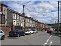
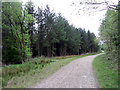
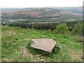
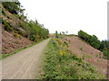
Photos of CF45 4PT

Area Information
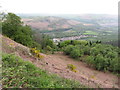
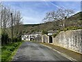
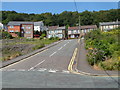
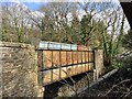
CF45 4PT represents a specific postal code cluster within the village of Abercynon, situated in the Cynon Valley of Rhondda Cynon Taf, Wales. This small residential area occupies just 1,020 square metres, though its identity is tied to a broader community history that dates back to the early industrial era. The location sits at the confluence of the River Cynon and the River Taff, known historically as Watersmeet. You are currently positioned approximately 16 miles north of Cardiff in a setting that has evolved from a transport interchange for canals and railways into a quiet, established neighbourhood. The population standing at 1,746 people means you live in a tight-knit community rather than a sprawling urban sprawl. Daily life here is defined by proximity to local landmarks and a distinct absence of modern planning constraints. The area is free from any designations as an Area of Outstanding Natural Beauty or protected wetland sites, offering a straightforward residential environment. Living in CF45 4PT connects you to a place with deep roots in Welsh industrial heritage, where the landscape has remained stable and free from significant flood risks. You find yourself in a settled ward that balances historical significance with practical, modern residential living.
- Area Type
- Postcode
- Area Size
- 1020 m²
- Population
- 1746
- Population Density
- 1617 people/km²
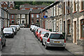
The housing market in CF45 4PT is defined almost entirely by traditional house ownership. With a home ownership rate of 63%, the area functions primarily as a buyer's market for semi-detached or detached family properties rather than a hub for private landlords or students. The accommodation type is strictly houses, which aligns with the historical development of Abercynon as a village centred on workers' housing and industrial infrastructure. You are looking at an existing stock of homes that have weathered changes in the local economy, from the peak of coal mining to the present day. The small size of the postcode area, covering only 1,020 square metres, limits the sheer volume of transactions but increases the exclusivity of each individual property. Buying a home here means entering a community where property values are supported by long-term resident investment. There are no indication of recent large-scale regeneration projects altering the housing stock. Instead, the value resides in the permanence of the tenures. Potential buyers can expect a straightforward purchase process without the complexities often found in high-density rental markets or volatile new-build developments.
House Prices in CF45 4PT
Showing 5 properties
| Address | Type | Beds | Baths | Last Sale Price | Last Sale Date | |
|---|---|---|---|---|---|---|
| 5 Well Street, Abercynon, CF45 4PT | house | 4 | - | £105,000 | Nov 2009 | |
| 4 Well Street, Abercynon, CF45 4PT | Terraced | - | - | - | - | |
| 1 Well Street, Abercynon, CF45 4PT | Terraced | - | - | - | - | |
| 2 Well Street, Abercynon, CF45 4PT | house | - | - | - | - | |
| 3 Well Street, Abercynon, CF45 4PT | Terraced | - | - | - | - |
Energy Efficiency in CF45 4PT
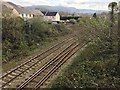
Your daily lifestyle in CF45 4PT is shaped by proximity to essential amenities within the wider Abercynon and local Cynon Valley network. You have direct access to three vital railway stations for your travel needs: Abercynon Railway Station, Quakers Yard Railway Station, and Penrhiwceiber Railway Station. For your shopping requirements, you are situated near several local retailers, including Co-op Ynysybwl, Spar Certas, and Co-op Treharris. These venues provide the staple goods and daily necessities no household can manage without. While there are no specific parks or leisure centres named in the immediate data, the area's character is defined by its historical heritage sites and riverfront locations. The nearby River Taff offers natural recreation opportunities, and the location near Watersmeet provides scenic walks away from the built environment. Retail choices are concentrated around the Co-op and Spar locations, ensuring you can cover your weekly shop without travelling to larger towns. The lifestyle here is practical and grounded, focusing on accessibility to core services rather than high-end entertainment or luxury shopping.
Amenities
Schools
Families considering homes in CF45 4PT will find immediate access to two notable educational institutions nearby. The nearest options include Abercynon Infants School and Ysgol Gymraeg Abercynon. These schools provide the primary education gateway for children living in this cluster of houses. Abercynon Infants School serves the younger demographic, offering early year education within the local community framework. Ysgol Gymraeg Abercynon offers a Welsh-medium education, reflecting the cultural strength of the Cynon Valley region where you live. While specific Ofsted ratings are not listed in the current data, the presence of these established schools indicates a functional local education network. The mix of school types suggests families have the option to choose between English-medium and Welsh-medium primary education. Living in this area puts you within practical reach of facilities designed to cater to the needs of the 30 to 64-year-old age group that dominates the local population. You do not need to travel far for your children's schooling, which is a significant advantage given the rural nature of the broader Abercynon ward.
| Rank | School | Type | Entry gender | Ages |
|---|
Explore more schools in this area
Go to Schools tabDemographics
The community living in CF45 4PT has evolved into a mature demographic profile, characterised by a median age of 47 years. The most common age range comprises adults between 30 and 64 years, indicating a prevalence of families and established households rather than young people or the elderly. You will find that home ownership is the dominant tenure, with 63% of residents owning their properties outright or with a mortgage. This high level of ownership suggests the area has not experienced recent influxes of social housing or new build rentals. The accommodation type is exclusively houses, meaning you will not find apartments or terraced flats within this specific postcode cluster. The predominant ethnic group is White, reflecting the historical settlement patterns of the Cynon Valley. There are no indications of rising deprivation in the available data, allowing you to focus on the stability of the neighbourhood. The density of 1,617 people per square kilometre indicates a reasonably populated but not overly congested residential zone. This demographic mix creates a quiet, stable society where neighbours often know each other for decades.
Household Size
Accommodation Type
Tenure
Ethnic Group
Religion
Household Composition
Age
Household Deprivation
NS-SEC
Explore more demographic insights in this area
Go to Demographics tabPlanning
Planning Constraints
- Flood RiskPremium
- Ramsar Wetland SitesPremium
- Area of Outstanding Natural BeautyPremium
- Protected Nature ReservePremium
- Protected WoodlandPremium
- Crime RiskPremium