Area Overview for CF43 4DD
Photos of CF43 4DD

Area Information
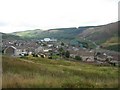
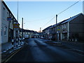
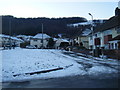
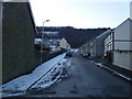
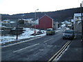
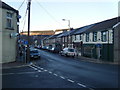
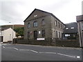
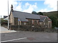
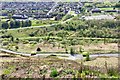
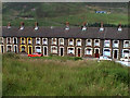
Living in CF43 4DD means residing within the village of Maerdy, a community situated at the head of the Rhondda Fach Valley in Rhondda Cynon Taf. This post-industrial settlement, originally a thriving coal-mining hub known for its radical politics, has transformed into a quieter residential cluster covering just 2.8 hectares. With a population of 1,769, the village maintains a tight-knit character while carrying the weight of its industrial history. The landscape is defined by the legacy of Mardy Colliery, which operated from 1875 until its closure in 1990. Today, the area stands as a testament to economic regeneration, moving away from heavy industry towards a standard domestic life. The name itself derives from the Welsh *maerdy*, meaning steward's house, referencing a medieval administrative building that once stood on the site. Residents enjoy the proximity of the historic valley settings without the dense urban pressures often found elsewhere in South Wales. The staggered transition from an agricultural area to a bustling mining town, and finally to its current state, has shaped a unique community identity. Most homes here are detached or semi-detached structures typical of the era they were built, surrounding the few remaining landmarks of the past. While the colliery is gone, the village retains memorials that honour its working-class heritage. This specific postcode covers a small residential area where the pace of life is likely slower than in larger towns like Treorchy, yet it remains connected to the wider region through local transport links and nearby amenities.
- Area Type
- Postcode
- Area Size
- 2.8 hectares
- Population
- 1769
- Population Density
- 201 people/km²
The housing market in CF43 4DD is characterised by a predominance of houses, which aligns with the post-industrial character of the village. With 57% of residents owning their homes, the area reflects a market where ownership is the norm rather than the exception. This high rate of home ownership suggests that properties here are sought after by people looking for stability and space rather than transient rental housing. The accommodation type is almost exclusively houses, meaning buyers can expect to find detached or semi-detached homes rather than the flats or apartments found in urban centres. This suggests a quieter, less dense living environment typical of village life in the Rhondda valleys. Prospective buyers looking at homes in CF43 4DD should be aware that the stock is rooted in the village's history as a mining community. The architecture and distribution of properties likely reflect the development phases after the colliery closure in 1990 and the area's designation as a Communities First Area in 2002. The small size of the residential cluster, covering only 2.8 hectares, limits the variety of property types available compared to broader postcode areas. Consequently, the options for new estate purchases are likely restricted, and value may depend heavily on individual property maintenance and location relative to the village centre.
House Prices in CF43 4DD
Showing 53 properties
| Address | Type | Beds | Baths | Last Sale Price | Last Sale Date | |
|---|---|---|---|---|---|---|
| 11 North Terrace, Maerdy, Ferndale, CF43 4DD | Terraced | 2 | 1 | £63,500 | Nov 2023 | |
| 13 North Terrace, Maerdy, Ferndale, CF43 4DD | Terraced | 3 | 1 | £67,950 | Oct 2023 | |
| 5 North Terrace, Maerdy, Ferndale, CF43 4DD | Terraced | 2 | 1 | £75,000 | Oct 2023 | |
| 27 North Terrace, Maerdy, Ferndale, CF43 4DD | house | - | - | £82,000 | Apr 2023 | |
| 29 North Terrace, Maerdy, Ferndale, CF43 4DD | Terraced | 3 | 1 | £68,000 | Sep 2022 | |
| Siloa Villa, North Terrace, Maerdy, Ferndale, CF43 4DD | Detached | 4 | 2 | £135,000 | Mar 2021 | |
| 28 North Terrace, Maerdy, Ferndale, CF43 4DD | house | - | - | £50,000 | Feb 2021 | |
| 1 North Terrace, Maerdy, Ferndale, CF43 4DD | Terraced | 2 | 1 | £39,995 | Dec 2019 | |
| Maenllwyd, North Terrace, Maerdy, Ferndale, CF43 4DD | Detached | 3 | 1 | £110,000 | Sep 2019 | |
| 33 North Terrace, Maerdy, Ferndale, CF43 4DD | house | - | - | £71,000 | Mar 2019 |
Energy Efficiency in CF43 4DD
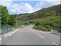
Daily life in CF43 4DD is supported by a selection of amenities within practical reach of the village. Residents have five retail outlets nearby, including a Spar, an Iceland Treorchy, and a Lidl Treorchy. These shops provide the essentials required for running a household without needing to travel far. For travel, there are five railway stations listed in the immediate vicinity: Treorchy Railway Station, Ynyswen Railway Station, and Ton Pentre Railway Station. Although the Maerdy Branch itself closed to passengers in 1964, these neighbouring stations likely provide essential rail links to Swansea and Cardiff, forming the primary public transport hub for the wider area. The village itself lacks commercial destinations within its 2.8-hectare boundary, meaning daily shopping trips extend to Treorchy. This setup creates a lifestyle where the village serves as a quiet residential hub, while convenience stores and transport hubs are located in the surrounding industrial villages. The community retains the atmosphere of a post-industrial settlement that has adapted to modern retail needs. There is no data on specific leisure venues, parks, or dining establishments within the immediate cluster. Therefore, entertainment and recreation options depend entirely on access to Treorchy and the rest of the Rhondda Fach Valley.
Amenities
Schools
Families considering living in CF43 4DD have access to Maerdy Infants School, which serves as the primary educational institution listed for this locality. This institution is classified under the 'other' category in available records, indicating it caters to younger children, specifically infants. There is no data provided regarding the Ofsted rating for Maerdy Infants School, so parents cannot assess its performance quality based on the available information. As the only school named in the research for this specific postcode, the educational landscape for primary education is limited to this single facility. The absence of secondary schools or further education colleges within the immediate data scope suggests that older children would likely travel to schools in larger neighbouring settlements such as Treorchy or Ton Pentre. For families with children of infant age, the proximity of Maerdy Infants School is a key advantage, offering a local option within the established village community. However, the lack of information on exam results or inspection ratings means that schools near CF43 4DD cannot be evaluated on academic performance. Parents will need to look beyond this postcode for secondary education options, as the provided data does not list any other educational establishments.
| Rank | School | Type | Entry gender | Ages |
|---|
Explore more schools in this area
Go to Schools tabDemographics
The community in CF43 4DD is dominated by adults, with a median age of 47 years. Most of the population falls within the 30-64 year age range, suggesting a stable family demographic rather than a transient workforce. Owning a property is common, with 57% of households reporting home ownership. This statistic indicates that the majority of residents have likely lived in their homes for a significant period, contributing to a settled neighbourhood. The predominant ethnicity in this area is White, reflecting the demographic patterns typical of South Wales. Almost exclusively, the accommodation consists of houses, distinguishing this locality from areas in the same postcode district that might feature more terraced houses or flats. There are no data points available regarding deprivation levels or income statistics within the provided research. This lack of specific income figures prevents detailed analysis of affordability compared to other Welsh towns. However, the high home ownership rate suggests financial stability for many residents. The absence of a diverse age profile, with a median age well above the national average, implies that the village may appeal to families with children or empty nesters rather than young professionals seeking city-centre living. The combination of a middle-aged population and high property ownership creates a quiet, established atmosphere where long-term residents likely form the core of the social fabric.
Household Size
Accommodation Type
Tenure
Ethnic Group
Religion
Household Composition
Age
Household Deprivation
NS-SEC
Explore more demographic insights in this area
Go to Demographics tabPlanning
Planning Constraints
- Flood RiskPremium
- Ramsar Wetland SitesPremium
- Area of Outstanding Natural BeautyPremium
- Protected Nature ReservePremium
- Protected WoodlandPremium
- Crime RiskPremium