Area Overview for CF42 6UT
Photos of CF42 6UT
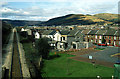
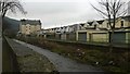
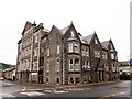
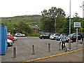
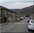
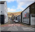
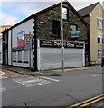
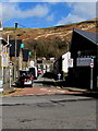
100 photos from this area
Area Information
Key information about the CF42 6UT including its size, population, and administrative classification.
- Area Type
- Postcode
- Area Size
- 4863 m²
- Population
- 1452
- Population Density
- 1408 people/km²
House Prices in CF42 6UT
14
Properties
£90,550
Average Sold Price
£31,500
Lowest Price
£170,000
Highest Price
Showing 14 properties
| Address | Type | Beds | Baths | Last Sale Price | Last Sale Date | |
|---|---|---|---|---|---|---|
| 7 Chepstow Road, Cwm Parc, Treorchy, CF42 6UT | Terraced | 3 | 1 | £170,000 | Mar 2023 | |
| 5 Chepstow Road, Cwm Parc, Treorchy, CF42 6UT | Terraced | 3 | 2 | £140,000 | Sep 2022 | |
| 8 Chepstow Road, Cwm Parc, Treorchy, CF42 6UT | house | 3 | 1 | £125,000 | Feb 2021 | |
| 9 Chepstow Road, Cwm Parc, Treorchy, CF42 6UT | Terraced | 6 | 3 | £123,500 | Jan 2021 | |
| 10 Chepstow Road, Cwm Parc, Treorchy, CF42 6UT | house | 3 | - | £58,000 | Jan 2015 | |
| 85 Chepstow Road, Cwm Parc, Treorchy, CF42 6UT | Bungalow | 2 | 2 | £120,000 | Jan 2014 | |
| 3 Chepstow Road, Cwm Parc, Treorchy, CF42 6UT | house | - | - | £50,000 | Dec 2011 | |
| 2 Chepstow Road, Cwm Parc, Treorchy, CF42 6UT | Land | - | - | £55,000 | Aug 2011 | |
| 6 Chepstow Road, Cwm Parc, Treorchy, CF42 6UT | Terraced | - | - | £32,500 | May 1998 | |
| 4 Chepstow Road, Cwm Parc, Treorchy, CF42 6UT | house | - | - | £31,500 | Apr 1998 |
Page 1 of 2
Energy Efficiency in CF42 6UT
Amenities
Schools
| Rank | School | Type | Entry gender | Ages |
|---|
Explore more schools in this area
Go to Schools tabDemographics
Household Size
Two person
most common
Accommodation Type
Houses
most common
Tenure
80
majority
Ethnic Group
White
most common
Religion
N/A
most common
Household Composition
N/A
most common
Age
47
median
Adults (30-64 years)
most common
Household Deprivation
N/A
with no deprivation
NS-SEC
28
in Lower managerial occupations
Explore more demographic insights in this area
Go to Demographics tabPlanning
Planning Constraints
- Flood RiskPremium
- Ramsar Wetland SitesPremium
- Area of Outstanding Natural BeautyPremium
- Protected Nature ReservePremium
- Protected WoodlandPremium
- Crime RiskPremium