Area Overview for CF42 5YD
Photos of CF42 5YD
Area Information
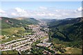
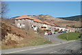
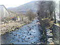
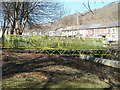
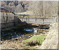
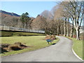
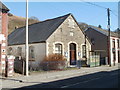
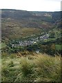
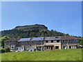
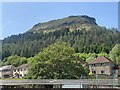
CF42 5YD is a small residential postcode cluster in Rhondda Cynon Taf, Wales, with a population of 1,484 and a density of 109 people per square kilometre. It lies in the upper Rhondda Fawr valley, historically shaped by the Bute Estate’s 19th-century industrial mining ventures. The area’s character blends historic architecture—such as 19th-century chapels, terraced housing, and early council homes—with modern infrastructure. Daily life here is rooted in a community of adults aged 30–64, many of whom own their homes. The postcode covers parts of Treherbert, a village with a legacy of coal mining that once drove its economy. Today, the area is served by multiple rail stations, including Treherbert and Ynyswen, and features modest retail options like Spar and Iceland. While the population is small, the area’s proximity to natural landscapes and historical sites, such as the Forest Town social enterprise, hints at a balance between heritage and contemporary development. Living here means navigating a compact, close-knit environment where community ties and historical context remain influential.
- Area Type
- Postcode
- Area Size
- Not available
- Population
- 1484
- Population Density
- 109 people/km²
CF42 5YD is a predominantly owner-occupied area, with 67% of residents living in homes they own. The accommodation type is mainly houses, which suggests a focus on family homes and single-family properties rather than flats or apartments. This composition indicates a housing stock that is likely older, reflecting the area’s 19th-century origins as a mining settlement. The small population and limited postcode area mean the property market is confined to a narrow geographic footprint, potentially offering fewer options for buyers. However, the presence of historic buildings, such as terraced housing and early council homes, may appeal to those seeking characterful properties. Buyers should consider nearby areas for more variety, but CF42 5YD’s compact nature ensures a cohesive, low-density residential environment. The lack of rental data implies a market skewed towards long-term ownership, though proximity to rail stations and retail amenities may support secondary demand.
House Prices in CF42 5YD
No properties found in this postcode.
Energy Efficiency in CF42 5YD
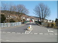
The lifestyle in CF42 5YD is shaped by its compact size and proximity to practical amenities. Nearby rail stations—Treherbert, Ynyswen, and Treorchy—offer easy access to regional destinations, while retail options like Spar and Iceland provide essentials. The area’s historic character, with buildings such as 19th-century chapels and terraces, adds a distinct architectural flavour. Though the postcode is small, it includes spaces like allotment gardens and early council housing, suggesting a mix of communal and private outdoor areas. The presence of the Forest Town initiative hints at ongoing efforts to enhance local amenities through natural resource management. For residents, daily life balances historical preservation with modern convenience, though the limited range of amenities means some services may require travel beyond the immediate area. The small community size fosters a close-knit environment, where local traditions and historical sites remain accessible.
Amenities
Schools
The nearest school to CF42 5YD is Penpych Community Primary School, which is categorised as an "other" type in the data. No Ofsted rating is provided, so its performance cannot be assessed here. The absence of secondary schools within the immediate area means families may need to look further afield for comprehensive education. The presence of a primary school suggests the area supports early education, but the limited range of school types may require additional planning for secondary schooling. Given the small population, the school’s student body is likely modest, potentially fostering a close-knit educational environment. However, the lack of detailed information on school quality or capacity means prospective buyers should investigate further to understand the full range of educational opportunities available to children in CF42 5YD.
| Rank | School | Type | Entry gender | Ages |
|---|
Explore more schools in this area
Go to Schools tabDemographics
The population of CF42 5YD is predominantly adults aged 30–64, with a median age of 47. Home ownership stands at 67%, reflecting a community where most residents live in properties they own. The accommodation type is primarily houses, suggesting a mix of family homes and single-family dwellings. The predominant ethnic group is White, which aligns with broader demographic trends in the region. The area’s relatively low population density—109 people per square kilometre—indicates a spread-out residential layout, potentially offering more private outdoor space. The absence of specific deprivation data means quality of life assessments rely on other factors, such as connectivity and safety. With no protected natural sites or flood risks, the area’s stability is underscored by its low environmental constraints. However, the demographic profile suggests a mature population, which may influence local services and community dynamics.
Household Size
Accommodation Type
Tenure
Ethnic Group
Religion
Household Composition
Age
Household Deprivation
NS-SEC
Explore more demographic insights in this area
Go to Demographics tabPlanning
Planning Constraints
- Flood RiskPremium
- Ramsar Wetland SitesPremium
- Area of Outstanding Natural BeautyPremium
- Protected Nature ReservePremium
- Protected WoodlandPremium
- Crime RiskPremium