Area Overview for CF41 7SJ
Photos of CF41 7SJ
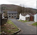

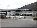
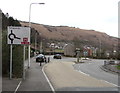
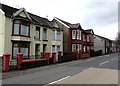
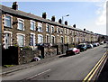
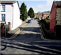
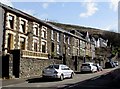
47 photos from this area
Area Information
Key information about the CF41 7SJ including its size, population, and administrative classification.
- Area Type
- Postcode
- Area Size
- 1.4 hectares
- Population
- Not available
- Population Density
- Not available
House Prices in CF41 7SJ
36
Properties
£82,736
Average Sold Price
£19,500
Lowest Price
£196,500
Highest Price
Showing 36 properties
| Address | Type | Beds | Baths | Last Sale Price | Last Sale Date | |
|---|---|---|---|---|---|---|
| 84 Penrhys Road, Ystrad, Pentre, CF41 7SJ | Terraced | 3 | 1 | £115,000 | Jul 2024 | |
| 42 Penrhys Road, Ystrad, Pentre, CF41 7SJ | Terraced | 3 | 1 | £90,000 | Jun 2024 | |
| 85 Penrhys Road, Ystrad, Pentre, CF41 7SJ | Terraced | 3 | 1 | £120,000 | Mar 2023 | |
| 49 Penrhys Road, Ystrad, Pentre, CF41 7SJ | house | 4 | 1 | £185,000 | Sep 2022 | |
| 82 Penrhys Road, Ystrad, Pentre, CF41 7SJ | Terraced | 4 | 1 | £85,000 | Feb 2022 | |
| 48 Penrhys Road, Ystrad, Pentre, CF41 7SJ | Terraced | 3 | - | £90,000 | Dec 2021 | |
| 59 Penrhys Road, Ystrad, Pentre, CF41 7SJ | house | - | - | £195,000 | Sep 2021 | |
| 58 Penrhys Road, Ystrad, Pentre, CF41 7SJ | Semi-detached | 6 | 2 | £196,500 | Sep 2019 | |
| 88 Penrhys Road, Ystrad, Pentre, CF41 7SJ | Terraced | 2 | 1 | £69,000 | Sep 2019 | |
| 53 Penrhys Road, Ystrad, Pentre, CF41 7SJ | house | - | - | £72,000 | Jun 2019 |
Page 1 of 4
Energy Efficiency in CF41 7SJ
Amenities
Schools
| Rank | School | Type | Entry gender | Ages |
|---|
Explore more schools in this area
Go to Schools tabDemographics
Household Size
One person
most common
Accommodation Type
Houses
most common
Tenure
72
majority
Ethnic Group
White
most common
Religion
N/A
most common
Household Composition
N/A
most common
Age
47
median
Adults (30-64 years)
most common
Household Deprivation
N/A
with no deprivation
NS-SEC
24
in Lower managerial occupations
Explore more demographic insights in this area
Go to Demographics tabPlanning
Planning Constraints
- Flood RiskPremium
- Ramsar Wetland SitesPremium
- Area of Outstanding Natural BeautyPremium
- Protected Nature ReservePremium
- Protected WoodlandPremium
- Crime RiskPremium