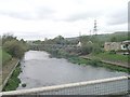
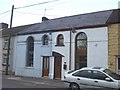
Area Overview for CF37 5SN
Photos of CF37 5SN


Area Information
CF37 5SN is a small residential postcode area in Wales, covering 3.5 hectares and home to 2,098 people. Its population density of 512 people per square kilometre reflects a compact, closely knit community. Situated in the town of Pontypridd, this area lies at the midpoint between Merthyr Tydfil and Cardiff, historically serving as a commercial and industrial hub. The town’s development was shaped by 19th-century transport infrastructure, including the Glamorganshire Canal and the Brown Lennox Chainworks, which transformed it from a rural settlement into a thriving centre. Today, CF37 5SN retains a mix of heritage and modernity, with residents benefiting from proximity to retail, rail, and educational facilities. The area’s strategic location makes it a gateway to the Rhondda Valleys, offering both convenience and a connection to the region’s industrial past. With a median age of 47 and a population skewed toward adults aged 30–64, the community is stable and family-oriented, reflecting a balance between established residents and those seeking a quieter, suburban lifestyle.
- Area Type
- Postcode
- Area Size
- 3.5 hectares
- Population
- 2098
- Population Density
- 512 people/km²
The property market in CF37 5SN is characterised by a high rate of home ownership (79%) and a focus on houses rather than flats or apartments. This suggests a market primarily serving families and long-term residents, with limited rental activity. The small area size (3.5 hectares) and modest population (2,098) mean housing stock is likely limited, potentially leading to competition among buyers. The dominance of owner-occupied homes indicates a community with a strong sense of place, where properties are often held for the long term. For prospective buyers, this means a focus on existing homes rather than new developments, with potential for investment in established properties. However, the small scale of the area may also mean limited scope for expansion or new builds, requiring buyers to consider nearby suburbs for additional options.
House Prices in CF37 5SN
Showing 4 properties
| Address | Type | Beds | Baths | Last Sale Price | Last Sale Date | |
|---|---|---|---|---|---|---|
| Petrol Station, Tesco Superstore, Tesco Approach Road, Upper Boat, Pontypridd, CF37 5SN | Retail | - | - | - | - | |
| Travel Money, Tesco Superstore, Tesco Approach Road, Upper Boat, Pontypridd, CF37 5SN | shop | - | - | - | - | |
| Pharmacy, Tesco Superstore, Tesco Approach Road, Upper Boat, Pontypridd, CF37 5SN | shop | - | - | - | - | |
| Tesco, Tesco Superstore, Tesco Approach Road, Upper Boat, Pontypridd, CF37 5SN | retail_financial | - | - | - | - |
Energy Efficiency in CF37 5SN
The lifestyle in CF37 5SN is shaped by its proximity to retail and transport hubs. Nearby amenities include Tesco Pontypridd, Farmfoods Pontypridd, and Iceland Midway, offering a range of shopping and grocery options. The area’s rail connections, including Trefforest and Pontypridd stations, provide access to broader regional networks, facilitating both commuting and leisure travel. While specific parks or leisure facilities are not listed, the town’s historical character—marked by sites like Sardis Chapel and St Catherine’s Church—adds cultural depth to daily life. The presence of retail and transport infrastructure suggests a practical, convenience-driven lifestyle, with residents able to meet everyday needs without long commutes. The compact nature of the area also fosters a sense of community, with local amenities serving as focal points for social interaction.
Amenities
Schools
Residents of CF37 5SN have access to three schools within practical reach: Hawthorn Primary School, Hawthorn High School, and Ysgol Afon Wen. These institutions cover primary and secondary education, though specific Ofsted ratings are not provided. The inclusion of both English and Welsh-medium schools (Ysgol Afon Wen) reflects the area’s linguistic diversity and commitment to bilingual education. For families, this mix ensures options for both Welsh and English-language learning, catering to different cultural and educational preferences. The proximity of these schools to residential areas suggests a community prioritising family-friendly infrastructure, with easy access to essential educational services. However, without performance data, it is unclear how these schools compare to others in the region.
| Rank | School | Type | Entry gender | Ages |
|---|
Explore more schools in this area
Go to Schools tabDemographics
The population of CF37 5SN has a median age of 47, with the majority of residents falling within the 30–64 age range. This suggests a community dominated by working-age adults and families, rather than younger or older demographics. Home ownership is high at 79%, indicating a strong presence of long-term residents and a market skewed toward owner-occupied properties. The accommodation type is predominantly houses, which aligns with the area’s residential character and suggests a preference for family homes over flats. The predominant ethnic group is White, though no further breakdown of diversity is provided. The age profile and ownership levels imply a stable, settled population with limited turnover, which can be advantageous for buyers seeking a consistent, low-traffic housing market. However, the lack of data on deprivation or income levels means the area’s economic diversity remains unquantified.
Household Size
Accommodation Type
Tenure
Ethnic Group
Religion
Household Composition
Age
Household Deprivation
NS-SEC
Explore more demographic insights in this area
Go to Demographics tabPlanning
Planning Constraints
- Flood RiskPremium
- Ramsar Wetland SitesPremium
- Area of Outstanding Natural BeautyPremium
- Protected Nature ReservePremium
- Protected WoodlandPremium
- Crime RiskPremium