Area Overview for SY21 9PN
Photos of SY21 9PN
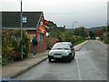
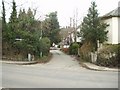
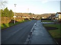
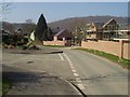
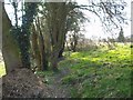
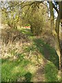
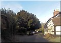
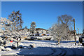
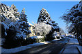


77 photos from this area
Area Information
Key information about the SY21 9PN including its size, population, and administrative classification.
- Area Type
- Postcode
- Area Size
- 2.2 hectares
- Population
- 2258
- Population Density
- 39 people/km²
House Prices in SY21 9PN
25
Properties
£190,868
Average Sold Price
£95,000
Lowest Price
£318,000
Highest Price
Showing 25 properties
| Address | Type | Beds | Baths | Last Sale Price | Last Sale Date | |
|---|---|---|---|---|---|---|
| 5 Acrefield Avenue, Guilsfield, Welshpool, SY21 9PN | Bungalow | 2 | 1 | £210,000 | Sep 2025 | |
| Chesford, 23 Acrefield Avenue, Guilsfield, Welshpool, SY21 9PN | Bungalow | 3 | 1 | £275,000 | Jan 2025 | |
| 29 Acrefield Avenue, Guilsfield, Welshpool, SY21 9PN | Bungalow | 3 | 1 | £275,000 | Sep 2024 | |
| 14 Acrefield Avenue, Guilsfield, Welshpool, SY21 9PN | Bungalow | 3 | 1 | £185,000 | Oct 2023 | |
| 31 Acrefield Avenue, Guilsfield, Welshpool, SY21 9PN | Bungalow | 3 | 1 | £275,000 | Oct 2023 | |
| 1 Acrefield Avenue, Guilsfield, Welshpool, SY21 9PN | Bungalow | - | - | £116,500 | Jan 2023 | |
| 27 Acrefield Avenue, Guilsfield, Welshpool, SY21 9PN | Bungalow | - | - | £318,000 | Mar 2022 | |
| 21 Acrefield Avenue, Guilsfield, Welshpool, SY21 9PN | Bungalow | 3 | 1 | £268,000 | Feb 2021 | |
| 9 Acrefield Avenue, Guilsfield, Welshpool, SY21 9PN | Bungalow | - | - | £143,500 | Aug 2019 | |
| 16 Acrefield Avenue, Guilsfield, Welshpool, SY21 9PN | Bungalow | 3 | 1 | £210,000 | Aug 2019 |
Page 1 of 3
Energy Efficiency in SY21 9PN
Amenities
Schools
| Rank | School | Type | Entry gender | Ages |
|---|
Explore more schools in this area
Go to Schools tabDemographics
Household Size
Two person
most common
Accommodation Type
Houses
most common
Tenure
77
majority
Ethnic Group
White
most common
Religion
N/A
most common
Household Composition
N/A
most common
Age
47
median
Adults (30-64 years)
most common
Household Deprivation
N/A
with no deprivation
NS-SEC
30
in Lower managerial occupations
Explore more demographic insights in this area
Go to Demographics tabPlanning
Planning Constraints
- Flood RiskPremium
- Ramsar Wetland SitesPremium
- Area of Outstanding Natural BeautyPremium
- Protected Nature ReservePremium
- Protected WoodlandPremium
- Crime RiskPremium