Area Overview for SA11 5YD
Photos of SA11 5YD


Area Information
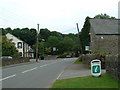
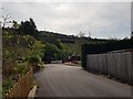
Living in SA11 5YD means settling into a specific residential cluster in Wales defined by its scale and setting. This postcode covers a small population of 2,082 people across a landscape with a density of just 19 people per square kilometre. You are part of a community where space is defined more by the distance between properties than by high-rise architecture or crowded streets. The area functions as a quiet residential zone rather than a commercial hub, offering a retreat from the busier towns surrounding Glynneath and Neath. Daily life here revolves around proximity to green spaces and a low-volume environment where neighbours often know one another by sight. There is no traffic congestion or dense urban noise, which suits those seeking a calm routine. The location provides a direct connection to the broader Vale of Neath without the intensity of town centre living. You gain access to essential services without being embedded in a bustling metropolis. This balance makes the area attractive for individuals who value privacy while maintaining reasonable access to regional necessities. The distinct character of SA11 5YD comes from its focus on housing stability and a slow-paced lifestyle.
- Area Type
- Postcode
- Area Size
- Not available
- Population
- 2082
- Population Density
- 19 people/km²
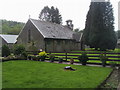
The property market in SA11 5YD is dominated by private ownership, with 78 percent of homes held by their owners. Houses constitute the main accommodation type, meaning you will find a stock of detached and semi-detached dwellings rather than flats or terraced rows. This market structure indicates a region where residents choose to build equity and put down roots over renting. For buyers considering SA11 5YD, the high ownership rate signals a stable estate where properties are treated as long-term assets rather than temporary stops. There are no properties here defined by speculation or rapid flipping. The 24 percent of homes not owned by occupants likely represent holiday homes or long-term rentals tied to specific family needs. The housing stock caters to the median age of 47, offering layouts that support multi-generational living or retired couples. There is no mix of student accommodation or temporary worker housing. This consistency means valuation is driven by structural condition and location rather than市场 demand for transient tenancies. You should expect a market where buyers scrutinise the physical state of properties for decades of use. The predominance of houses ensures that you are looking at standalone homes with private grounds and higher privacy levels.
House Prices in SA11 5YD
No properties found in this postcode.
Energy Efficiency in SA11 5YD
Your lifestyle in SA11 5YD centres on practical access to four major retail outlets located within practical reach of the residential cluster. These include Co-op Glynneath, Tesco Glynneath, and Asda Neath, which provide a solid foundation for grocery shopping and general provisioning. You do not have a high street immediately adjacent to the postcode, but these three large supermarkets form the economic heart of your daily trips. Residents typically drive or cycle to these locations rather than walking to a local marketplace. A fourth retail option exists within the broader neighbourhood, ensuring that specific budget or specialist items are obtainable. The area lacks cafes, pubs, or leisure venues within the immediate postcode boundary, meaning entertainment and dining happen in the surrounding towns. This setup prioritises convenience and essential shopping over nightlife or social hubs. You will plan your weekly shop around the opening hours of Tesco or Asda Neath. This retail configuration suits families who value low-cost essentials and efficient shopping trips over frequent casual dining. The distance from commercial centres aligns with the quiet character of SA11 5YD, keeping noise and foot traffic away from homes.
Amenities
Schools
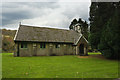
Families considering SA11 5YD will find four maintained schools within practical reach, all designated as 'other' category institutions. These facilities include Ysgol Thomas Stephens, Caehopkin C.P. School, Coelbren C.P. School, and Penycae C.P. School. Each of these schools serves the local community with a combination of primary and secondary education provisions. The 'other' classification suggests that these institutions may have specific curriculum focuses or operational types distinct from the standard comprehensive model. You do not have access to performative metrics in the provided information regarding Ofsted ratings, but the presence of these named establishments confirms a dedicated educational infrastructure. The variety of school names indicates ownership by different syndicates or local trusts dedicated to the area's learners. Living in SA11 5YD places you within catchment distances of these key institutions. The concentration of four schools within the immediate vicinity means you do not need to travel far for education access. This cluster supports families with multiple children or those wishing to access different educational philosophies offered by the distinct institutions. The availability of named schools like Coelbren and Caehopkin demonstrates a commitment to local education retention.
| Rank | School | Type | Entry gender | Ages |
|---|
Explore more schools in this area
Go to Schools tabDemographics
The community in SA11 5YD has a clearly defined demographic profile centred on established residents rather than a transient population. Your neighbours are predominantly adults aged between 30 and 64 years, with a median age of 47. This age distribution indicates a stable neighbourhood where lifetime ties often run deep between households. Home ownership stands at a high level of 78 percent, which suggests that the local estate is built on long-term settlement rather than short-term tenancies. Houses form the primary accommodation type, fitting the preference for detached or semi-detached properties common in this age group. The predominant ethnic group is White, reflecting the traditional settlement patterns of the region. With nearly four out of five residents owning their homes, the area enjoys a sense of permanence that is rare in many parts of the UK. You are unlikely to encounter the instability associated with high turnover rental blocks. The population composition points to families that have raised children locally and settled permanently. This demography creates a predictable environment where community norms are well established and respected. The low population density complements this profile, avoiding the overcrowding that sometimes undermines community cohesion in denser urban centres.
Household Size
Accommodation Type
Tenure
Ethnic Group
Religion
Household Composition
Age
Household Deprivation
NS-SEC
Explore more demographic insights in this area
Go to Demographics tabPlanning
Planning Constraints
- Flood RiskPremium
- Ramsar Wetland SitesPremium
- Area of Outstanding Natural BeautyPremium
- Protected Nature ReservePremium
- Protected WoodlandPremium
- Crime RiskPremium