Area Overview for Abermule with Llandyssil Community
Photos of Abermule with Llandyssil Community


Area Information
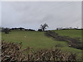
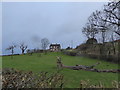
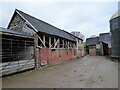
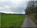
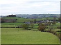
Abermule with Llandyssil Community stands as a distinct civil parish in Wales, covering an expansive 29.3 km². Living in Abermule with Llandyssil Community offers a defined rural setting where daily life revolves around the parish's specific boundaries and natural landscape. The area functions as a self-contained community rather than a dense urban centre, meaning residents rely heavily on local amenities and personal transport for most errands. This spatial layout creates a quiet environment, suitable for those who prefer space and tranquility over city noise. The parish status implies a local governance structure focused on the specific needs of its inhabitants within this 29.3 km² footprint. You can expect a residential experience shaped by the size of the parish and its rural classification. The community is not an isolated pocket but a recognised administrative unit in Wales. Your daily routine will reflect the scale of the area, where distances to towns matter more than in a bustling town centre. The distinctive nature of Abermule with Llandyssil Community comes from combining rural living with official parish status. This setup provides a stable home environment for families and individuals seeking a settled life away from major highways. The 29.3 km² size allows for scattered housing, meaning you may find homes in various pockets across the parish rather than on one main street.
- Area Type
- Parish
- Area Size
- 29.3 km²
- Population
- Not available
- Population Density
- Not available
Demographics
The people living in Abermule with Llandyssil Community form a settled population with a median age of 70. This figure indicates that the area is predominantly inhabited by older residents. Most of the total population falls within this older age bracket, shaping the local social activities and service needs. You are looking at a community where the majority of homes are occupied by those in retirement or later life stages. Home ownership levels in Abermule with Llandyssil Community stand at 75%. This high percentage means that three quarters of the households own their accommodation outright or with a mortgage. Rental homes are less common here compared to cities or student towns, giving the area a stable character. The household composition reflects these older occupants, with families likely to be smaller or comprised of single individuals. Accommodation types across the parish support this ownership pattern, favouring detached or semi-detached houses suitable for retirees. Diversity in terms of predominant ethnic group and religion is less visible in the provided data, suggesting a fairly traditional community makeup. No specific deprivation statistics are listed, but the high ownership rate suggests financial stability among residents. Living in Abermule with Llandyssil Community means joining a demographic where long-term residents hold most properties.
Household Size
Accommodation Type
Tenure
Ethnic Group
Religion
Household Composition
Age
Household Deprivation
NS-SEC
Explore more demographic insights in this area
Go to Demographics tabPlanning
Planning Constraints
- Flood RiskPremium
- Ramsar Wetland SitesPremium
- Area of Outstanding Natural BeautyPremium
- Protected Nature ReservePremium
- Protected WoodlandPremium
- Crime RiskPremium