Area Overview for Hay Community
Photos of Hay Community


Area Information
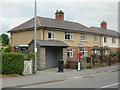
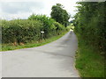
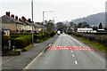
Living in Hay Community offers a distinct experience within a small civil parish in Wales. This area covers just 1.6 km², creating a compact environment where residents are accustomed to close proximity. You will find a place defined by its intimate scale rather than sprawling development. The quiet nature of this parish suggests daily life revolves around local rhythms and immediate neighbours. It is a setting where the built environment sits alongside natural features, though the extent of those features varies across specific plots. Those seeking a settlement with clear boundaries and a defined administrative identity will recognise Hay Community immediately. The area does not boast vast infrastructure or commercial centres, which shapes how you navigate your week. Instead, routine activities likely depend on walking or short drives to nearby towns. This concentration of space means you interact with your immediate surroundings constantly. The identity of the parish remains rooted in its geographic tightness. When you consider buying a home here, you are entering a space where every plot and street is close to another. This focus on locality creates a working landscape that differs significantly from larger rural sprawls. ### The community profile in Hay Community reflects a distinctly older population. Your neighbours are predominantly senior, with a median age of 70. Age: Total records indicate that the total population falls into this older demographic bracket. You are unlikely to find many young families or students living in this parish. Home ownership stands at a high level of 65%, suggesting a majority of residents purchased their properties long ago. Household composition data confirms that the area is structured around total household units, implying established and settled living arrangements. Accommodation types also reflect this total spectrum, meaning the housing stock has evolved over many years. While specific ethnic groups, religion, and detailed household breakdowns are not detailed in current records, the overall picture points to a stable, mature society. There is no indication of rapid demographic shifts or new migration patterns. The high ownership rate means most families will stay put rather than move frequently. This stability impacts services and the pace of change. You should expect a neighbourhood where traditions and long-term residents maintain a strong grip on local character. ### The property market in Hay Community is characterised by entrenched home ownership rather than a transient rental sector. With 65% of homes owned by their residents, this parish is clearly an owner-occupied area. You will find that the majority of the housing stock has passed through multiple generations of ownership. This dynamic contrasts sharply with cities where tenancy agreements dominate the market. The accommodation type data suggests a mix of established dwellings that have remained in private hands for decades. When viewing homes in Hay Community, expect to spend time negotiating with sitting owners rather than agents managing portfolios of rental properties. The low size of the parish at 1.6 km² limits the total inventory available, reinforcing the idea that finding specific properties requires local knowledge. The market here does not react with the speed seen in larger urban centres. Instead, transactions depend on individual sales of existing assets. This structure means prices may reflect personal history as much as current market trends. For buyers, the high ownership percentage is a double-edged sword. It signals a stable market but can also mean fewer options for those seeking quick moves or modern builds not yet occupied by owners. ### Digital connectivity in Hay Community presents a mixed picture that you must weigh against your working requirements. Mobile coverage scores well at 72, indicating a good standard for making calls or using navigation on your way to nearby amenities. However, fixed broadband quality scores 40, which represents a poor standard for high-speed internet needs. This gap means you may experience significant disruptions during video calls or large file downloads. Remote workers living in Hay Community should treat the broadband connection as a potential bottleneck. Daily life online may feel sluggish compared to urban areas with guaranteed full-fibre speeds. Streaming services could buffer during peak hours, and important work documents might upload slowly. The disparity between mobile and fixed lines suggests that telephony works reliably, but data transmission struggles under heavier loads. You must consider whether the local network can support your specific digital habits. If your job relies heavily on stable high-speed connections, a lower broadband score like 40 is a critical factor. Residents relying solely on mobile hotspots will find more satisfaction, but those needing a wired connection for work or education face real challenges. ### Environmental and safety assessments reveal a landscape of low flood risk but with specific planning constraints to consider. Flood risk is minimal, with a score of 3.79, marking a pass and indicating low flood risk coverage. You can leave your garden furniture outside without fear of water damage from heavy rains. Planning constraints, however, introduce nuances that affect development and land value. The area successfully passes checks for Ramsar wetland sites and Areas of Outstanding Natural Beauty, with scores of 0 for both. This means no protected wetlands or scenic landscapes threaten to halt standard construction projects. Yet, warnings do exist regarding nature reserves and protected woodland, with scores of 5.54 and 0.73. These areas contain protected status, meaning you cannot simply build new homes or alter existing structures without strict permission. Crime risk data is unavailable as it is restricted to areas in England, so no local statistics currently define safety on streets. You will have to rely on general observations rather than official crime maps. While the environmental risks are manageable, the protection statuses for nature and woodlands create a complex regime for any property improvements you plan to make. ### Who typically lives in Hay Community? The median age is 70, making Hay Community home to a predominantly elderly population. High home ownership at 65% shows that most residents have settled families down for the long term. This demographic profile is consistent across the parish, with very few young households joining the community. Can I work from home effectively in Hay Community? Mobile coverage is good with a score of 72, but fixed broadband is poor at 40. You may struggle with fast internet speeds for video conferencing or large downloads. A stable mobile hotspot might suffice, but a wired connection could disappoint you. Is the area safe from flooding? Yes, Hay Community has a low flood risk coverage with a score of 3.79. This safety rating applies across the parish, meaning you face minimal threat from water accumulation after heavy rainfall events. Are there restrictions on building new structures? Protected nature reserves carry a warning level, and protected woodland exists within the 1.6 km² area. While there are no Ramsar sites or AONBs, these protections limit future construction on specific plots without special permissions.
- Area Type
- Parish
- Area Size
- 1.6 km²
- Population
- Not available
- Population Density
- Not available
Demographics
The community profile in Hay Community reflects a distinctly older population. Your neighbours are predominantly senior, with a median age of 70. Age: Total records indicate that the total population falls into this older demographic bracket. You are unlikely to find many young families or students living in this parish. Home ownership stands at a high level of 65%, suggesting a majority of residents purchased their properties long ago. Household composition data confirms that the area is structured around total household units, implying established and settled living arrangements. Accommodation types also reflect this total spectrum, meaning the housing stock has evolved over many years. While specific ethnic groups, religion, and detailed household breakdowns are not detailed in current records, the overall picture points to a stable, mature society. There is no indication of rapid demographic shifts or new migration patterns. The high ownership rate means most families will stay put rather than move frequently. This stability impacts services and the pace of change. You should expect a neighbourhood where traditions and long-term residents maintain a strong grip on local character. ### The property market in Hay Community is characterised by entrenched home ownership rather than a transient rental sector. With 65% of homes owned by their residents, this parish is clearly an owner-occupied area. You will find that the majority of the housing stock has passed through multiple generations of ownership. This dynamic contrasts sharply with cities where tenancy agreements dominate the market. The accommodation type data suggests a mix of established dwellings that have remained in private hands for decades. When viewing homes in Hay Community, expect to spend time negotiating with sitting owners rather than agents managing portfolios of rental properties. The low size of the parish at 1.6 km² limits the total inventory available, reinforcing the idea that finding specific properties requires local knowledge. The market here does not react with the speed seen in larger urban centres. Instead, transactions depend on individual sales of existing assets. This structure means prices may reflect personal history as much as current market trends. For buyers, the high ownership percentage is a double-edged sword. It signals a stable market but can also mean fewer options for those seeking quick moves or modern builds not yet occupied by owners. ### Digital connectivity in Hay Community presents a mixed picture that you must weigh against your working requirements. Mobile coverage scores well at 72, indicating a good standard for making calls or using navigation on your way to nearby amenities. However, fixed broadband quality scores 40, which represents a poor standard for high-speed internet needs. This gap means you may experience significant disruptions during video calls or large file downloads. Remote workers living in Hay Community should treat the broadband connection as a potential bottleneck. Daily life online may feel sluggish compared to urban areas with guaranteed full-fibre speeds. Streaming services could buffer during peak hours, and important work documents might upload slowly. The disparity between mobile and fixed lines suggests that telephony works reliably, but data transmission struggles under heavier loads. You must consider whether the local network can support your specific digital habits. If your job relies heavily on stable high-speed connections, a lower broadband score like 40 is a critical factor. Residents relying solely on mobile hotspots will find more satisfaction, but those needing a wired connection for work or education face real challenges. ### Environmental and safety assessments reveal a landscape of low flood risk but with specific planning constraints to consider. Flood risk is minimal, with a score of 3.79, marking a pass and indicating low flood risk coverage. You can leave your garden furniture outside without fear of water damage from heavy rains. Planning constraints, however, introduce nuances that affect development and land value. The area successfully passes checks for Ramsar wetland sites and Areas of Outstanding Natural Beauty, with scores of 0 for both. This means no protected wetlands or scenic landscapes threaten to halt standard construction projects. Yet, warnings do exist regarding nature reserves and protected woodland, with scores of 5.54 and 0.73. These areas contain protected status, meaning you cannot simply build new homes or alter existing structures without strict permission. Crime risk data is unavailable as it is restricted to areas in England, so no local statistics currently define safety on streets. You will have to rely on general observations rather than official crime maps. While the environmental risks are manageable, the protection statuses for nature and woodlands create a complex regime for any property improvements you plan to make. ### Who typically lives in Hay Community? The median age is 70, making Hay Community home to a predominantly elderly population. High home ownership at 65% shows that most residents have settled families down for the long term. This demographic profile is consistent across the parish, with very few young households joining the community. Can I work from home effectively in Hay Community? Mobile coverage is good with a score of 72, but fixed broadband is poor at 40. You may struggle with fast internet speeds for video conferencing or large downloads. A stable mobile hotspot might suffice, but a wired connection could disappoint you. Is the area safe from flooding? Yes, Hay Community has a low flood risk coverage with a score of 3.79. This safety rating applies across the parish, meaning you face minimal threat from water accumulation after heavy rainfall events. Are there restrictions on building new structures? Protected nature reserves carry a warning level, and protected woodland exists within the 1.6 km² area. While there are no Ramsar sites or AONBs, these protections limit future construction on specific plots without special permissions.
Household Size
Accommodation Type
Tenure
Ethnic Group
Religion
Household Composition
Age
Household Deprivation
NS-SEC
Explore more demographic insights in this area
Go to Demographics tabPlanning
Planning Constraints
- Flood RiskPremium
- Ramsar Wetland SitesPremium
- Area of Outstanding Natural BeautyPremium
- Protected Nature ReservePremium
- Protected WoodlandPremium
- Crime RiskPremium