Area Overview for Caersws Community
Photos of Caersws Community
Area Information
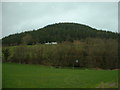
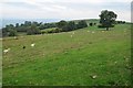
Living in Caersws Community offers a distinctly rural lifestyle within a civil parish covering 44.7 square kilometres. This area sits on the edge of the Brecon Beacons, providing expansive open spaces and a connection to the countryside that characterises much of the surrounding region. The community feels quiet and self-contained, unlike the faster pace of larger towns in Powys. Your daily life here revolves around local amenities and access to wider strategic routes rather than dense urban centres. You will find that Caersws Community is a place where time moves a little slower. The landscape is defined by rolling hills and agricultural land, making it ideal for those seeking seclusion without being entirely cut off. Although the parish is relatively small, its location allows for reasonable travel times to key regional hubs. Residents here often appreciate the clean air and peaceful surroundings, qualities that define the living experience in this part of Wales. When considering homes in Caersws Community, you are choosing a setting defined by its openness and proximity to natural features. The area supports a traditional county town feel despite its parish status. You should know that this locality combines the benefits of a settled community with the broader recreational opportunities available nearby. Whether you are looking for a first home or an addition to an existing portfolio, Caersws Community presents a specific market niche focused on rural living.
- Area Type
- Parish
- Area Size
- 44.7 km²
- Population
- Not available
- Population Density
- Not available
Demographics
The demographic profile of Caersws Community reveals a mature population with a median age of 70 years. This figure indicates a resident base significantly older than the national average. The most common age grouping falls under the 'Age: Total' category, reflecting the wide variety of ages present, though the median suggests retirement residents dominate the headcount. You are likely to encounter fewer young families compared to younger areas, which shapes the general atmosphere of the parish. Home ownership stands at 74 per cent, which is a notably high level compared to the wider UK average. This statistic confirms that Caersws Community is primarily an owner-occupied area. You will find that leases and tenancies are far less common here than in city centres or university towns. This high percentage of owner residents often correlates with greater community stability and long-term investment in local properties. The available data does not specify breakdowns for household composition or predominant ethnic groups within the parish records provided. Consequently, the demographic picture relies heavily on the age and ownership figures mentioned earlier. The presence of protected woodland within the area also hints at environmental value that may influence who chooses to settle here. Those looking to understand the diversity of the local population may find the high home ownership rate a significant factor in the community's character.
Household Size
Accommodation Type
Tenure
Ethnic Group
Religion
Household Composition
Age
Household Deprivation
NS-SEC
Explore more demographic insights in this area
Go to Demographics tabPlanning
Planning Constraints
- Flood RiskPremium
- Ramsar Wetland SitesPremium
- Area of Outstanding Natural BeautyPremium
- Protected Nature ReservePremium
- Protected WoodlandPremium
- Crime RiskPremium