Area Overview for SA73 1UA
Photos of SA73 1UA
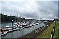
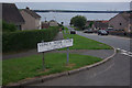
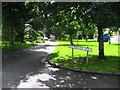
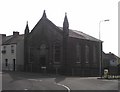
53 photos from this area
Area Information
Key information about the SA73 1UA including its size, population, and administrative classification.
- Area Type
- Postcode
- Area Size
- 9047 m²
- Population
- 2173
- Population Density
- 1689 people/km²
House Prices in SA73 1UA
11
Properties
£230,357
Average Sold Price
£125,000
Lowest Price
£305,500
Highest Price
Showing 11 properties
| Address | Type | Beds | Baths | Last Sale Price | Last Sale Date | |
|---|---|---|---|---|---|---|
| 8 St Annes Place, Neyland, SA73 1UA | Bungalow | 2 | 2 | £260,000 | Oct 2025 | |
| Bishops Meadows, 9 St Annes Place, Neyland, SA73 1UA | Bungalow | 3 | 1 | £305,500 | Oct 2025 | |
| Westlands, 6 St Annes Place, Neyland, SA73 1UA | Detached | 3 | 1 | £300,000 | Jun 2023 | |
| 4 St Annes Place, Neyland, SA73 1UA | Bungalow | 2 | 1 | £180,000 | Aug 2022 | |
| 10 St Annes Place, Neyland, SA73 1UA | Bungalow | 2 | 2 | £155,000 | Jan 2022 | |
| 7 St Annes Place, Neyland, SA73 1UA | Bungalow | 3 | 2 | £287,000 | Dec 2021 | |
| Bandol, 5 St Annes Place, Neyland, SA73 1UA | Bungalow | 3 | 1 | £125,000 | Jul 2015 | |
| 3 St Annes Place, Neyland, SA73 1UA | Bungalow | 3 | - | - | - | |
| The Hideaway, 11 St Annes Place, Neyland, SA73 1UA | Detached | - | - | - | - | |
| 1 St Annes Place, Neyland, SA73 1UA | house | - | - | - | - |
Page 1 of 2
Energy Efficiency in SA73 1UA
Amenities
Schools
| Rank | School | Type | Entry gender | Ages |
|---|
Explore more schools in this area
Go to Schools tabDemographics
Household Size
Two person
most common
Accommodation Type
Houses
most common
Tenure
68
majority
Ethnic Group
White
most common
Religion
N/A
most common
Household Composition
N/A
most common
Age
47
median
Adults (30-64 years)
most common
Household Deprivation
N/A
with no deprivation
NS-SEC
24
in Lower managerial occupations
Explore more demographic insights in this area
Go to Demographics tabPlanning
Planning Constraints
- Flood RiskPremium
- Ramsar Wetland SitesPremium
- Area of Outstanding Natural BeautyPremium
- Protected Nature ReservePremium
- Protected WoodlandPremium
- Crime RiskPremium