Area Overview for SA65 9HE
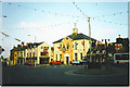
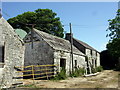
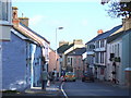
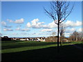
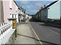
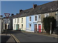
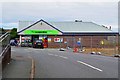
Photos of SA65 9HE

Area Information
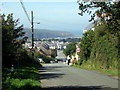
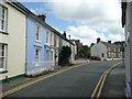
Living in SA65 9HE means residing within a specific postcode area covering a small residential cluster in South Wales. This location hosts a population of 1,592 people, creating a tight-knit environment where neighbours often know one another. With a population density of 947 people per square kilometre, the area is compact without being overcrowded. You will find yourself in a setting defined by clarity and directness; there are no hidden shadows or undeclaring statements about what constitutes daily life here. The community is established and grounded, suitable for those who prefer a settled pace over a chaotic urban rhythm. The demographic profile suggests a significant overlap with existing families and established residents rather than transient young professional clusters. You are stepping into an environment where the housing stock is predominantly houses, distinguishing it from high-rise blocks or suburban flats. The area's character is shaped by its size and specific location codes, which bracket a distinct neighbourhood identity. When you visit, the immediate surroundings reflect a community that has developed over time, supported by a consistent home ownership rate. This stability offers a tangible sense of permanence that can be hard to find in rapidly shifting market districts.
- Area Type
- Postcode
- Area Size
- Not available
- Population
- 1592
- Population Density
- 947 people/km²
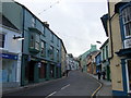
The property market in SA65 9HE is characterised by a landscape dominated by houses, which aligns with the accommodation types specified for the postcode. You are looking at a stock where private home ownership reaches 66%, significantly outweighing the rental sector. This statistic indicates that the area functions as an owner-occupied zone where residents typically stay long-term rather than cycling through the housing market quickly. A high ownership rate often correlates with steadier property values and less turnover compared to towns reliant on student rentals or temporary workers. Since the area consists primarily of houses, the architectural variety will reflect traditional Welsh building styles rather than the glass and steel found in coastal regeneration zones. When searching for homes in SA65 9HE, you are likely to encounter properties that have been lived in by their owners for decades, evidenced by the home ownership figure. This stability means you are often buying an established residence rather than a newly built development. The market dynamics here are simpler; sellers are usually motivated by life changes within the existing community rather than investor flips. For buyers seeking a substantive foothold in Wales, the high ownership percentage suggests a neighbourhood where people value the ground they stand on. This market condition reduces the volatility often seen in areas with large student populations or office workers commuting from the city.
House Prices in SA65 9HE
Showing 5 properties
| Address | Type | Beds | Baths | Last Sale Price | Last Sale Date | |
|---|---|---|---|---|---|---|
| Visitor Centre, Fishguard Town Hall, Market Square, Fishguard, SA65 9HE | Leisure | - | - | - | - | |
| First Floor Offices, Fishguard Town Hall, Market Square, Fishguard, SA65 9HE | Office | - | - | - | - | |
| Fishguard Town Hall, Market Square, Fishguard, SA65 9HE | commercial | - | - | - | - | |
| Unit 1 Fishguard Market, Fishguard Town Hall, Market Square, Fishguard, SA65 9HE | commercial | - | - | - | - | |
| Market And Library, Fishguard Town Hall, Market Square, Fishguard, SA65 9HE | Office | - | - | - | - |
Energy Efficiency in SA65 9HE
Your daily life in SA65 9HE is supported by a selection of practical amenities located within practical reach. For shopping needs, you have access to four retail options explicitly listed as Co-op High, Spar, and Tesco Goodwick. These supermarkets allow you to manage your weekly groceries without driving far from your doorstep. Nearby, the Fishguard Ferry Terminal offers direct transport connections across the border, which may appeal to you if you have interests in Pembrokeshire or international travel. Transport connections are further enhanced by two rail stations: Fishguard & Goodwick Railway Station and Fishguard Harbour Railway Station. These stations provide links to major cities and ports, reducing the isolation that sometimes afflicts coastal communities. The presence of these specific venues creates a lifestyle where convenience meets connectivity. You can combine a trip to the Co-op High with a connection at the nearby railway station, streamlining your weekly errands and travel plans. The area avoids the clutter of large shopping malls, opting instead for essential services that neighbours can access locally. This configuration suits those who value a straightforward routine where essentials are within walking or short driving distance. You do not need to plan for long journeys for basic sustenance; your neighbourhood supplies your core requirements efficiently.
Amenities
Schools
There are three schools in the vicinity of SA65 9HE, all falling under the 'other' category classification provided in your current data set. The nearest educational institutions include Ysgol Iau Abergwaun, Ysgol Bro Gwaun, and Ysgol Glannau Gwaun. Because the data lists these establishments without specifying primary or secondary status or Ofsted ratings, you cannot currently verify their specialisms or performance grades through this specific dataset. However, the presence of three schools in close proximity suggests that a range of phases exists within the broader local catchment area. This cluster indicates that families living in SA65 9HE do not need to travel far to access formal education. The name 'Ysgol' confirms that Welsh-medium education is a significant component of the local schooling landscape. While the specific type for each individual institution is not detailed as primary or secondary here, the concentration of schools near the postcode implies a well-provisioned area for dependents. You will need to cross-reference these names with the latest Welsh Government educational records to determine exact years of entry or Ofsted ratings, as this information is not contained within the provided assessment. Nevertheless, the availability of multiple nearby options provides a solid foundation for families considering this neighbourhood for its educational accessibility.
| Rank | School | Type | Entry gender | Ages |
|---|
Explore more schools in this area
Go to Schools tabDemographics
The community in SA65 9HE is defined by a median age of 47 years, placing the area firmly within a mature demographic bracket. Most residents fall into the adult age range of 30 to 64 years, creating a neighbourhood where life stages focus on mid-life careers and family management rather than teenage decades or retirement years alone. This age profile implies a population well-established in the locality, with many households having long-term ties to the postcodes and streets within SA65 9HE. Home ownership stands at 66%, indicating that two-thirds of households have a financial stake in their property. This high rate of ownership suggests a community resistant to transient rental movement and focused on building equity. The primary accommodation type is houses, meaning you will not find high-rise apartments or converted commercial units dominating the streets. Furthermore, the predominant ethnic group is White, reflecting a demographic makeup typical of many Welsh coastal regions. There are no ambiguities regarding the social fabric here; the statistics paint a clear picture of a stable, older demographic living in detached or semi-detached homes. You can expect neighbourhood interactions to centre around local concerns, garden plots, and community events rather than the shifting dynamics of a university town. The demographic consistency supports a predictable quality of life where long-term residents shape the local culture.
Household Size
Accommodation Type
Tenure
Ethnic Group
Religion
Household Composition
Age
Household Deprivation
NS-SEC
Explore more demographic insights in this area
Go to Demographics tabPlanning
Planning Constraints
- Flood RiskPremium
- Ramsar Wetland SitesPremium
- Area of Outstanding Natural BeautyPremium
- Protected Nature ReservePremium
- Protected WoodlandPremium
- Crime RiskPremium