Area Overview for SA65 9AQ
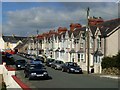
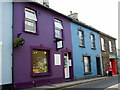
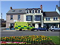
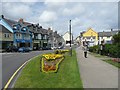
Photos of SA65 9AQ


Area Information
Living in SA65 9AQ means residing in a specific postcode area covering a small residential cluster within Wales. This compact community has a population of 1,592 residents, creating a close-knit environment with a population density of 947 people per square kilometre. The area functions as a stable residential hub rather than a sprawling town, offering a sense of familiarity that particularly appeals to families and long-term settled residents. Daily life here revolves around proximity to essential services, with properties situated close to retail outlets and transport links that connect the Postcode to Fishguard and beyond. The local character is defined by its housing stock and community cohesion, providing a distinct alternative to larger urban centres. Prospective buyers appreciate that this location combines the convenience of being near major railway stations and ferry terminals with the quiet atmosphere of a smaller settlement. The size of the area ensures that you are never far from neighbours, yet the layout preserves a degree of residential seclusion. Understanding the specific nature of SA65 9AQ helps you determine if this small residential cluster fits your lifestyle requirements.
- Area Type
- Postcode
- Area Size
- Not available
- Population
- 1592
- Population Density
- 947 people/km²
The property market in SA65 9AQ is characterised by a strong owner-occupier presence, with 66 per cent of homes owned by residents. This high ownership rate suggests that the market consists largely of established families and long-term residents rather than transient tenants or investors flipping properties. The predominant accommodation type is houses, which reflects the demographic preference for larger living spaces suitable for adults aged 30 to 64 years. Buying homes in SA65 9AQ typically involves entering a market where sellers are often motivated by lifestyle changes or relocation rather than the need for quick sales common in rental-heavy districts. This dynamic can create a more stable purchasing environment for prospective buyers. The focus on houses means you will find a variety of family-sized properties rather than small flats or purpose-built rental blocks. For those considering living in SA65 9AQ, the nature of the housing stock offers traditional living standards. The fact that two-thirds of residents own their homes indicates that property values have historically appreciated enough to build significant equity. When researching homes in SA65 9AQ, you are likely to encounter a range of residential properties that have been passed down through generations or purchased by families building a legacy in this specific postcode area.
House Prices in SA65 9AQ
No properties found in this postcode.
Energy Efficiency in SA65 9AQ
The lifestyle in SA65 9AQ benefits from a convenient network of amenities within practical reach of residents. For daily shopping, you can visit Co-op High, Spar, and Tesco Goodwick, providing a solid blend of retail options without needing to travel extensively. Fishguard Ferry Terminal offers direct access to international crossings, making travel from this specific postcode area straightforward for visitors returning from abroad. For commuters and rail pass holders, two railway stations are nearby: Fishguard & Goodwick Railway Station and Fishguard Harbour Railway Station. These stations connect the residential cluster to broader rail networks, facilitating easy journeys to Cardiff, London, and other major cities. Having four retail outlets close by means you are rarely more than a short drive away from everyday necessities. The presence of the ferry terminal and railway stations adds a layer of connectivity that elevates this area from a quiet village to a well-connected transit point. Shopping at Tesco Goodwick or grabbing supplies at Co-op High fulfills most weekly needs, while the transport links ensure you can leave quickly when required.
Amenities
Schools
Families considering schools near SA65 9AQ have access to several educational institutions within the immediate vicinity. Ysgol Iau Abergwaun serves as an option for local education, providing childcare or primary-level schooling for residents. Ysgol Bro Gwaun and Ysgol Glannau Gwaun are also located nearby, offering further educational avenues for children growing up in the area. While specific Ofsted ratings are not listed in the current dataset, the presence of multiple schools suggests a развитая infrastructure for education in the region. The mix of school names indicates a network that can cater to different educational needs, potentially covering the early years through secondary education depending on the specific catchment areas of each institution. For those with children, the proximity of these schools means you do not need to travel far for daily attendance. Living in SA65 9AQ places you within reasonable reach of Ysgol Iau Abergwaun, Ysgol Bro Gwaun, and Ysgol Glannau Gwaun. Checking individual catchment boundary maps will confirm eligibility for each, but the geographical clustering of these educational facilities supports the community's family-oriented character.
| Rank | School | Type | Entry gender | Ages |
|---|
Explore more schools in this area
Go to Schools tabDemographics
The demographic profile of SA65 9AQ indicates a mature community with a median age of 47 years. Most commonly, adults aged between 30 and 64 years make up the resident population, suggesting a household base focused on stability and family life. Home ownership stands at 66 per cent, meaning the majority of residents own their properties outright or with a mortgage. This high ownership rate contrasts with areas where rental markets dominate, indicating a preference for long-term settlement among locals. The predominant ethnic group within this postcode is White, reflecting the broader demographic trends often found in established Welsh residential areas. Accommodation types are primarily houses, which aligns with the needs of families and the age profile of the residents. This combination of a mature age range and high ownership suggests a neighbourhood where residents are likely to stay for the long term. You can expect a community where neighbours know each other, and decision-making regarding local improvements often benefits from deep-rooted resident engagement. The lack of large student populations or transient rental housing creates a quieter, more consistent living environment for those seeking a permanent home base.
Household Size
Accommodation Type
Tenure
Ethnic Group
Religion
Household Composition
Age
Household Deprivation
NS-SEC
Explore more demographic insights in this area
Go to Demographics tabPlanning
Planning Constraints
- Flood RiskPremium
- Ramsar Wetland SitesPremium
- Area of Outstanding Natural BeautyPremium
- Protected Nature ReservePremium
- Protected WoodlandPremium
- Crime RiskPremium