Area Overview for SA62 5LL
Photos of SA62 5LL
Area Information
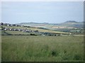
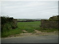
The postcode district of SA62 5LL defines a specific residential cluster within Wales covering 63 hectares. This small area supports a population of 1398 residents, resulting in a low density of just 27 people per square kilometre. Living in SA62 5LL means experiencing a spacious environment where individual dwellings have access to considerable terrs of ground. The layout suggests a quiet, semi-rural character rather than a high-density urban setting. You will find that daily life here revolves around a close-knit community spread across five square miles of land. This distribution of homes creates an atmosphere where neighbours are likely to know one another, fostering a strong local sense. The area functions as a distinct pocket of habitability, removed from the noise and congestion of larger towns. For those considering homes in SA62 5LL, the physical layout offers generous outdoor space. The expansive nature of the 63-hectare footprint allows for a peaceful routine. Residents enjoy the benefits of significant air and sunlight. The cluster remains well-defined yet integrated into the broader Welsh landscape. You gain a residence that balances privacy with community access. This specific postcode represents a deliberate choice for spacious, low-density living in South Wales.
- Area Type
- Postcode
- Area Size
- 63.0 hectares
- Population
- 1398
- Population Density
- 27 people/km²
The housing stock in SA62 5LL is defined by a predominance of houses, with no flats or apartments present. This structural characteristic means you will only find detached, semidetached, or terrace housing within the 63-hectare boundary. The area exhibits exceptional stability, with 81 per cent of households classified as owner-occupiers. This high ownership rate indicates that most homes here are family residences rather than investment lets. Buying a home in SA62 5LL typically involves purchasing a property you can live in for decades, not a asset for quick flipping. The house‑only stock eliminates competition from rental-seeker dynamics that platter urban flat markets. Consequently, the local market likely moving at a considered pace with value driven by location and property condition rather than speculation. Home buyers looking at this small area will find a community where residents have elected to stay. The absence of social housing or rental blocks reinforces the traditional nature of the local estate. If you are seeking a house in SA62 5LL, you enter a market accustomed to longevity. Prices may reflect the cost of maintaining larger properties in a low-density setting. The 81 per cent ownership figure signals a secure neighbourhood where owners plan for the future. This market structure suits those who value stability over speed.
House Prices in SA62 5LL
Showing 10 properties
Energy Efficiency in SA62 5LL
Residents of SA62 5LL have practical access to local amenities, though options remain limited. Within walking distance or a short drive, you can find five retail outlets including Spar – Certas Energy – Square, Spar Certas, and Co-op High. These shops cover essentials without the need to travel far from home. Travelers with business needs can reach RAF Brawdy airport within practical reach. The one airport nearby provides flight options for those leaving the region. For those requiring rail connections, Fishguard & Goodwick Railway Station is the nearest stop. This station links you to wider regional networks. Ferry passengers can utilize the Fishguard Ferry Terminal for cross-channel travel to Pembrokeshire or beyond. The presence of a ferry terminal distinguishes SA62 5LL from inland postcodes. Daily life involves a mix of local convenience stores and accessible transport hubs. You do not need to travel deep into towns for basic groceries. The single airport and rail station provide useful logistics for work or holidays. The five retail units ensure daily needs are met without congestion. This blend of local shops and transport nodes defines the lifestyle rhythm of the area.
Amenities
Schools
There are two other schools located near SA62 5LL: Ysgol Gymunedol Croesgoch and Mathry V.C.P. School. Both institutions are categorised as "other" regarding their specific educational type in the current dataset. You cannot determine exact Ofsted ratings from the available information, so any judgment on quality must rely on local reputation or further independent research. The presence of these two schools covers the educational needs of the 1398 residents within the area. Families moving to SA62 5LL will need to consider which of these two schools serves their children best. The mix of school names suggests a combination of community and voluntary aided history. Since specific rating data is absent, you should contact the schools directly for the latest performance metrics. The distance to these facilities is practical for the residential cluster. Local parents rely on these two institutions for primary or secondary education, depending on the specific status of each school. This limited selection means families in SA62 5LL have a defined, local range of options. You must evaluate the suitability of Ysgol Gymunedol Croesgoch and Mathry V.C.P. School against your children's needs. The lack of a third nearby school reinforces the importance of these two named institutions.
| Rank | School | Type | Entry gender | Ages |
|---|
Explore more schools in this area
Go to Schools tabDemographics
The community in SA62 5LL reflects a stable, established population with a median age of 47 years. Most residents fall into the adult age range of 30 to 64 years, indicating a workforce-active demographic. This age profile suggests a neighbourhood suitable for career-oriented individuals and families seeking a settled life. Home ownership stands at a high rate of 81 per cent, confirming that the vast majority of households own their properties outright or with a mortgage. This statistic points to an area where long-term residents have put down significant roots. The accommodation type is exclusively houses, meaning you will find no flats or apartments in this cluster. The predominant ethnic group is White, which aligns with the broader demographic trends of many rural Welsh communities. Social stability appears evident from the high ownership figure. Deprivation is not explicitly quantified in the available records, but the high home ownership rate generally correlates with financial security. You can expect a resident pool that has lived in the area for many years. The social fabric relies on longstanding connections rather than transient populations. This demographic profile creates a predictable and reliable community environment for new arrivals.
Household Size
Accommodation Type
Tenure
Ethnic Group
Religion
Household Composition
Age
Household Deprivation
NS-SEC
Explore more demographic insights in this area
Go to Demographics tabPlanning
Planning Constraints
- Flood RiskPremium
- Ramsar Wetland SitesPremium
- Area of Outstanding Natural BeautyPremium
- Protected Nature ReservePremium
- Protected WoodlandPremium
- Crime RiskPremium