Area Overview for Rudbaxton Community
Photos of Rudbaxton Community
Area Information
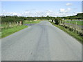
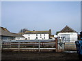
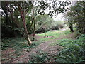
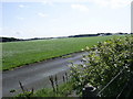
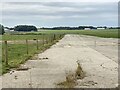
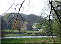
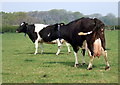
Living in Rudbaxton Community places you on the edge of Haverfordwest within a distinctly rural civil parish in Pembrokeshire, Wales. This area covers 20.1 km² and stretches along the Western Cleddau river valley, carrying the historic A40 road directly through its centre. The community includes the village of Crundale and smaller settlements such as Poyston Cross, Bethlehem, and Rudbaxton Water. While the 2011 population stood at 768, the landscape remains defined by gentle undulations and Ordovician mudstones rather than dense development. You will find a location rich in ancient history, featuring the Grade I listed St Michael's Church, which dates to the early 13th century, and Rudbaxton Rath. This Iron Age hillfort was adapted as a Norman motte during the 12th century within the Barony of Dungleddy. The site contains fourteen listed buildings and forty-nine additional structures of historical interest. Archaeological evidence confirms human activity here since the Neolithic period and Bronze Age. However, daily life reflects a quiet, inland character with no local commercial centres or major employers. Your immediate surroundings include the river and its tributaries, providing a natural backdrop to a setting that balances historical significance with modern rural living. The people of Rudbaxton Community have established a distinct demographic profile characterised by stability and age. With a median age of 70, this area has a notably older population compared to national averages. Most households consist of older residents, which significantly influences the local pace and social dynamics. A remarkable 82% of homes in Rudbaxton are owner-occupied, indicating a community deeply rooted in the locality with low transient rental churn. This high rate of home ownership suggests that many residents have lived here for decades, contributing to the area's quiet character. The diversity data reflects the small population size inherent to a civil parish of this scale, where social networks are typically close-knit. Given the high proportion of older adults, services and amenities tend to cater to an established demographic rather than a young, mobile workforce. You should expect a settled environment where neighbours often know each other well. The absence of significant youth influx or large family clusters reinforces the image of a retirement-friendly zone or a established home for long-term residents seeking a tranquil pace of life away from urban pressures. The housing stock in Rudbaxton Community is overwhelmingly dominated by owner-occupied properties, with a confirmed home ownership level of 82%. This figure signals that the local market functions primarily as a site for established families and retirees rather than a bustling rental sector. The remaining 18% of housing likely consists of long-term tenants or specific social housing allocations, though specific breakdowns for these groups are not detailed in available records. As part of a civil parish covering 20.1 km², the available properties range from historic homes linked to landmarks like the Congregational chapel in Crundale, built in 1837 and rebuilt in 1882, to later 20th-century expansions like Crundale itself. The presence of forty-nine structures of historical interest implies an area where older housing stock carries significant heritage value. Buyers looking at Rudbaxton communities should anticipate purchasing properties that require maintenance, given the age of the built environment and the small typical footprint of tenancy. The market is not driven by speculative investment but by local need and historical settlement. You will find fewer modern new-builds compared to larger towns, meaning inventory consists largely of character properties situated near the A40 or within established clusters like Rudbaxton Water. Economic drivers remain local, centred on agriculture rather than corporate office work, which further limits new large-scale construction projects. Digital connectivity in Rudbaxton Community supports remote working demands with a fixed broadband quality score of 94, which rates as excellent. This robust connection ensures reliable internet access for daily online tasks, full-time work from home, and streaming services without interruption. Mobile coverage is good, with a network quality score of 78, allowing for dependable communication via smartphone or tablet throughout most of the parish. This level of mobile signal is sufficient for navigating the rural landscape and handling essential calls, though you might experience minor variations in deeply rural pockets away from the main road. The physical transport links centre on the A40, a historical turnpike road running through the Western Cleddau valley connecting Haverfordwest to Fishguard. For rail access, Haverfordwest railway station sits approximately three miles south of the community. This distance is manageable by car for most residents wishing to combine transport options. The 2011 population density means bus services may be infrequent compared to towns, so relying on personal transport is standard. You will face no major planning constraints on road expansion, such as Ramsar wetland sites or Areas of Outstanding Natural Beauty, which often hamper infrastructure projects in other parts of the region. However, the protected nature reserves and woodlands suggest that road upgrades remain limited to preserve the environment. Environmental assessments for Rudbaxton Community indicate low risks regarding flooding and major planning constraints. The area passes fluor evaluation for flood risk with a score of 2.02, confirming low flood risk coverage for residents. There is no Ramsar wetland coverage and no inclusion in an Area of Outstanding Natural Beauty, meaning planning applications face fewer strict national landscape restrictions than in designated zones. These conditions provide clarity for those considering future property extensions or repairs. However, the presence of protected nature reserves presents a planning warning, which may affect certain construction projects. Similarly, protected woodland areas create a cautionary constraint, as development here requires careful consideration of environmental protections. You should verify specific local authority guidance before undertaking building works on land near these features. Crime risk data is currently unavailable for this specific parish, as official figures are published only for areas in England. This gap means you cannot rely on statistical crime rates to assess local safety, though the rural nature of the community typically correlates with lower crime incidents. The rural setting also means emergency response times may depend on distance from fire stations or police districts. Overall, the physical environment remains stable, with no identified safety hazards beyond standard rural precautions regarding weather and terrain. Which specific landmarks and historical sites define the local landscape?Rudbaxton Community features the Grade I listed St Michael's Church, which dates to the early 13th century, and Rudbaxton Rath, an Iron Age hillfort that served as a Norman motte in the 12th century. The area contains fourteen listed buildings and forty-nine other structures of historical interest, including a Congregational chapel built in Crundale in 1837. What is the property ownership situation like in this parish?Ninety-two percent of homes in Rudbaxton Community are owner-occupied, confirming that the market is dominated by long-term residents rather than renters. This high rate of home ownership suggests a settled population with strong local ties. How reliable is internet connectivity for remote workers?Fiber broadband availability is excellent with a quality score of 94, providing highly reliable internet for work or leisure. Mobile coverage is good with a score of 78, ensuring reasonable network performance across the rural parish and around the A40 road. Are there any planning restrictions I should be aware of when buying land?While there is no Area of Outstanding Natural Beauty or Ramsar site in Rudbaxton, the area contains protected nature reserves and protected woodland. These features may impose constraints on development plans or require special considerations for building new homes.
- Area Type
- Parish
- Area Size
- 20.1 km²
- Population
- Not available
- Population Density
- Not available
Demographics
The people of Rudbaxton Community have established a distinct demographic profile characterised by stability and age. With a median age of 70, this area has a notably older population compared to national averages. Most households consist of older residents, which significantly influences the local pace and social dynamics. A remarkable 82% of homes in Rudbaxton are owner-occupied, indicating a community deeply rooted in the locality with low transient rental churn. This high rate of home ownership suggests that many residents have lived here for decades, contributing to the area's quiet character. The diversity data reflects the small population size inherent to a civil parish of this scale, where social networks are typically close-knit. Given the high proportion of older adults, services and amenities tend to cater to an established demographic rather than a young, mobile workforce. You should expect a settled environment where neighbours often know each other well. The absence of significant youth influx or large family clusters reinforces the image of a retirement-friendly zone or a established home for long-term residents seeking a tranquil pace of life away from urban pressures. The housing stock in Rudbaxton Community is overwhelmingly dominated by owner-occupied properties, with a confirmed home ownership level of 82%. This figure signals that the local market functions primarily as a site for established families and retirees rather than a bustling rental sector. The remaining 18% of housing likely consists of long-term tenants or specific social housing allocations, though specific breakdowns for these groups are not detailed in available records. As part of a civil parish covering 20.1 km², the available properties range from historic homes linked to landmarks like the Congregational chapel in Crundale, built in 1837 and rebuilt in 1882, to later 20th-century expansions like Crundale itself. The presence of forty-nine structures of historical interest implies an area where older housing stock carries significant heritage value. Buyers looking at Rudbaxton communities should anticipate purchasing properties that require maintenance, given the age of the built environment and the small typical footprint of tenancy. The market is not driven by speculative investment but by local need and historical settlement. You will find fewer modern new-builds compared to larger towns, meaning inventory consists largely of character properties situated near the A40 or within established clusters like Rudbaxton Water. Economic drivers remain local, centred on agriculture rather than corporate office work, which further limits new large-scale construction projects. Digital connectivity in Rudbaxton Community supports remote working demands with a fixed broadband quality score of 94, which rates as excellent. This robust connection ensures reliable internet access for daily online tasks, full-time work from home, and streaming services without interruption. Mobile coverage is good, with a network quality score of 78, allowing for dependable communication via smartphone or tablet throughout most of the parish. This level of mobile signal is sufficient for navigating the rural landscape and handling essential calls, though you might experience minor variations in deeply rural pockets away from the main road. The physical transport links centre on the A40, a historical turnpike road running through the Western Cleddau valley connecting Haverfordwest to Fishguard. For rail access, Haverfordwest railway station sits approximately three miles south of the community. This distance is manageable by car for most residents wishing to combine transport options. The 2011 population density means bus services may be infrequent compared to towns, so relying on personal transport is standard. You will face no major planning constraints on road expansion, such as Ramsar wetland sites or Areas of Outstanding Natural Beauty, which often hamper infrastructure projects in other parts of the region. However, the protected nature reserves and woodlands suggest that road upgrades remain limited to preserve the environment. Environmental assessments for Rudbaxton Community indicate low risks regarding flooding and major planning constraints. The area passes fluor evaluation for flood risk with a score of 2.02, confirming low flood risk coverage for residents. There is no Ramsar wetland coverage and no inclusion in an Area of Outstanding Natural Beauty, meaning planning applications face fewer strict national landscape restrictions than in designated zones. These conditions provide clarity for those considering future property extensions or repairs. However, the presence of protected nature reserves presents a planning warning, which may affect certain construction projects. Similarly, protected woodland areas create a cautionary constraint, as development here requires careful consideration of environmental protections. You should verify specific local authority guidance before undertaking building works on land near these features. Crime risk data is currently unavailable for this specific parish, as official figures are published only for areas in England. This gap means you cannot rely on statistical crime rates to assess local safety, though the rural nature of the community typically correlates with lower crime incidents. The rural setting also means emergency response times may depend on distance from fire stations or police districts. Overall, the physical environment remains stable, with no identified safety hazards beyond standard rural precautions regarding weather and terrain. Which specific landmarks and historical sites define the local landscape?Rudbaxton Community features the Grade I listed St Michael's Church, which dates to the early 13th century, and Rudbaxton Rath, an Iron Age hillfort that served as a Norman motte in the 12th century. The area contains fourteen listed buildings and forty-nine other structures of historical interest, including a Congregational chapel built in Crundale in 1837. What is the property ownership situation like in this parish?Ninety-two percent of homes in Rudbaxton Community are owner-occupied, confirming that the market is dominated by long-term residents rather than renters. This high rate of home ownership suggests a settled population with strong local ties. How reliable is internet connectivity for remote workers?Fiber broadband availability is excellent with a quality score of 94, providing highly reliable internet for work or leisure. Mobile coverage is good with a score of 78, ensuring reasonable network performance across the rural parish and around the A40 road. Are there any planning restrictions I should be aware of when buying land?While there is no Area of Outstanding Natural Beauty or Ramsar site in Rudbaxton, the area contains protected nature reserves and protected woodland. These features may impose constraints on development plans or require special considerations for building new homes.
Household Size
Accommodation Type
Tenure
Ethnic Group
Religion
Household Composition
Age
Household Deprivation
NS-SEC
Explore more demographic insights in this area
Go to Demographics tabPlanning
Planning Constraints
- Flood RiskPremium
- Ramsar Wetland SitesPremium
- Area of Outstanding Natural BeautyPremium
- Protected Nature ReservePremium
- Protected WoodlandPremium
- Crime RiskPremium