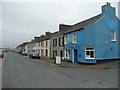
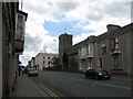
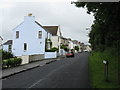
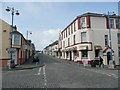
Area Overview for Pembroke Dock Community
Photos of Pembroke Dock Community


Area Information
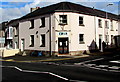
Living in Pembroke Dock Community offers a sense of established character within a defined civil parish on the Welsh coast. This settlement covers an area of 9.4 square kilometres and serves a population of 6,417 residents. The population density reaches 683 people per square kilometre, creating pockets of suburban or semi-rural life depending on your specific street. You will find a distinct residential atmosphere where daily routines blend with the local environment. This area stands apart from larger townships, offering a focused community feel rather than urban anonymity. Many residents appreciate the manageable size of the parish, which allows neighbours to know one another without the noise of a bustling city centre. The location provides proximity to the wider Pembrokeshire region while maintaining its own identity as a settled community. Prospective homebuyers know they are choosing a place with a clear demographic profile and a stable population base. The sheer number of homes accommodates this specific population, ensuring that services remain within reach of the 6,417 people who call this parish home. You can expect a lifestyle defined by these concrete boundaries and a known community network.
- Area Type
- Parish
- Area Size
- 9.4 km²
- Population
- 6417
- Population Density
- 683 people/km²
Demographics
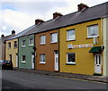
The demographic profile of Pembroke Dock Community reveals a distinct age structure compared to national averages. The median age for residents stands at 70 years, indicating a population skewed heavily towards older adults. Most households fall into age categories that reflect this senior demographic, suggesting a community accustomed to slower-paced living. Home ownership remains a central feature of daily life here, with 59% of all households owning their properties outright or with mortgages. This ownership rate is significantly higher than that of many private rental markets, reinforcing the idea that residents have long-term roots in the area. Accommodation types and predominant ethnic groups follow the general trend seen across similar Welsh parishes, though specific breakdowns are not detailed in the current records. The high level of ownership means you are likely to deal with long-standing owners rather than transient renters when looking at homes in Pembroke Dock Community. This stability often translates to well-maintained properties and a sense of established neighbourhood order. You can expect a community where families and retirees have settled deeply into the local fabric.
Household Size
Accommodation Type
Tenure
Ethnic Group
Religion
Household Composition
Age
Household Deprivation
NS-SEC
Explore more demographic insights in this area
Go to Demographics tabPlanning
Planning Constraints
- Flood RiskPremium
- Ramsar Wetland SitesPremium
- Area of Outstanding Natural BeautyPremium
- Protected Nature ReservePremium
- Protected WoodlandPremium
- Crime RiskPremium