Area Overview for NP19 8DA
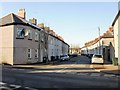
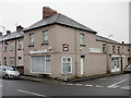
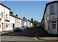
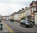
Photos of NP19 8DA


Area Information
Postcode NP19 8DA occupies a small residential cluster in Wales covering just 3747 square metres. This compact footprint houses 2349 residents, creating a dense settlement where neighbours are often familiar faces. Living in NP19 8DA means navigating a community defined by high population density, with 626952 people per square kilometre recorded for this specific zone. Such figures indicate a tightly knit environment rather than sprawling or spacious living. The area functions as a distinct pocket within Newport, blending residential needs with proximity to major services. You find yourself close to significant transport hubs and retail centres despite the limited physical space. This location serves as a practical base for families and commuters needing direct access to Newport's infrastructure. The high density suggests limited ground for expansion but offers convenience through proximity to urban amenities.
- Area Type
- Postcode
- Area Size
- 3747 m²
- Population
- 2349
- Population Density
- 11985 people/km²
Homes in NP19 8DA are characterised by a balance of owner-occupation and rental availability, with 51% of properties owned by their occupants. Houses form the primary accommodation type across this postcode, meaning buyers seeking terraced or detached homes will find a better match here than those looking for flat living. The high population density of 626952 people per square kilometre within the 3747 square metre area suggests a tight-knit housing stock where individual properties sit close together. Living in this small residential cluster offers proximity to essentials but may limit garden space or private outdoor areas compared to more expansive zones. The majority of residents having houses implies a traditional family housing stock rather than multi-unit blocks. When considering homes in NP19 8DA, you are entering a market defined by density and traditional housing forms rather than modern high-rise developments.
House Prices in NP19 8DA
Showing 15 properties
| Address | Type | Beds | Baths | Last Sale Price | Last Sale Date | |
|---|---|---|---|---|---|---|
| 8 Merriott Place, Newport, NP19 8DA | Terraced | 3 | 1 | £120,000 | Apr 2024 | |
| 3 Merriott Place, Newport, NP19 8DA | Semi-detached | 3 | 1 | £170,000 | Dec 2022 | |
| 13 Merriott Place, Newport, NP19 8DA | house | - | - | £93,500 | May 2021 | |
| 5 Merriott Place, Newport, NP19 8DA | Semi-detached | 3 | 1 | £135,000 | Dec 2020 | |
| 11 Merriott Place, Newport, NP19 8DA | Terraced | 3 | - | £137,500 | Apr 2019 | |
| 2 Merriott Place, Newport, NP19 8DA | Semi-detached | 3 | - | £88,500 | Dec 2018 | |
| 12 Merriott Place, Newport, NP19 8DA | Terraced | 4 | 2 | £95,000 | Aug 2015 | |
| 10 Merriott Place, Newport, NP19 8DA | Terraced | 3 | 2 | £97,750 | Apr 2011 | |
| 9 Merriott Place, Newport, NP19 8DA | Terraced | - | - | £84,950 | Mar 2004 | |
| 14A Merriott Place, Newport, NP19 8DA | Flat | - | - | £60,000 | May 2003 |
Energy Efficiency in NP19 8DA
Residents of NP19 8DA benefit from immediate access to a range of shopping and transport options. Five notable retail destinations operate within practical reach, including Tesco Caerleon, Asda Casnewydd, and Spar. These venues provide daily necessities, groceries, and convenience shopping without the need for long commutes. Transport links are extensive, with rail services connecting you to Newport Railway Station, Pye Corner Railway Station, and Rogerstone Railway Station. You can easily access regional networks from these stops. Additionally, Newport Ferry Terminal is available just one location away for water-based travel options. This proximity to multiple railway stations and a ferry terminal makes living in NP19 8DA highly convenient for both commuters and leisure travellers. The area functions as a quiet residential hub connected to vibrant commercial and transport nodes nearby.
Amenities
Schools
Families considering NP19 8DA have access to Fairoak Nursery School within the immediate vicinity. This facility operates as a nursery school, catering to the youngest members of the community before they enter primary education. As a small residential cluster, NP19 8DA relies on these early years provisions before directing children to broader catchment areas for primary and secondary schooling. The presence of Fairoak Nursery School supports the area's profile as a residential zone with young children. While no primary or secondary schools are listed for this specific postcode, the nursery option ensures early educational needs are met locally. You will need to research further for older children's education outside this specific zip code, but the neighbourhood infrastructure supports young families through this foundational stage. Living in NP19 8DA offers convenient access to early childhood learning alongside nearby town centres.
| Rank | School | Type | Entry gender | Ages |
|---|
Explore more schools in this area
Go to Schools tabDemographics
The community in NP19 8DA reflects a mature demographic profile with a median age of 47 years. Most common age groups are adults between 30 and 64 years, indicating a neighbourhood anchored by working-age families and established households. Home ownership stands at 51%, placing the area slightly above parity where residents own their properties compared to renters. Houses dominate the accommodation type inventory, distinguishing this cluster from developments featuring flats or apartments. The predominant ethnic group is White, shaping the social fabric of the local cluster. With such a high population density and specific age range, daily interactions are frequent and informal. You will encounter neighbours who have likely lived in the same homes for decades rather than transient occupancy. This stability often fosters a strong sense of locality within this small Welsh postcode sector.
Household Size
Accommodation Type
Tenure
Ethnic Group
Religion
Household Composition
Age
Household Deprivation
NS-SEC
Explore more demographic insights in this area
Go to Demographics tabPlanning
Planning Constraints
- Flood RiskPremium
- Ramsar Wetland SitesPremium
- Area of Outstanding Natural BeautyPremium
- Protected Nature ReservePremium
- Protected WoodlandPremium
- Crime RiskPremium