Area Overview for NP19 7SJ
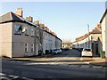
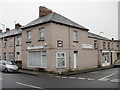
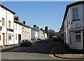
Photos of NP19 7SJ


Area Information
Living in NP19 7SJ means residing within a tightly knit residential cluster of 1.3 hectares. You are part of a community defined by its concentrations, boasting 1415 residents packed into a very small footprint. This postcode stands out because of its high population density, which creates a close-kitted neighbourhood atmosphere rather than the sprawling feel of larger settlements. The location sits firmly within Wales, offering a specific type of localised living experience where distance is minimal. Daily life here is characterised by proximity to your neighbours and immediate access to surrounding transport hubs. The area does not span multiple towns but functions as a concentrated hub within the Newport region. Homebuyers should expect a living situation where every foot of the 1.3 hectares is utilised for housing or immediate community use. You benefit from being in a designated spot that bridges local housing needs with nearby infrastructure. The compact nature of the postcode ensures that you are never far from essential services, rail connections, or retail options that define your routine. This is a place defined by its specific boundaries and its role as a dense residential node in a larger county.
- Area Type
- Postcode
- Area Size
- 1.3 hectares
- Population
- 1415
- Population Density
- 4333 people/km²
The property market in NP19 7SJ is distinctly leaning towards owner-occupation rather than a rental-heavy zone. With 77 per cent of homes owned by their occupants, the area offers security and stability for buyers viewing this postcode. Houses make up the predominant accommodation type, meaning you will find traditional residential structures rather than purpose-built rental complexes or high-density flats. This housing stock reflects a traditional market where residents have invested in their properties over time. If you are looking at homes in NP19 7SJ, you are entering an environment where ownership is the primary mode of tenure. The small area size of 1.3 hectares restricts the volume of available stock, making each property highly specific to its current owner. This concentration of house owners creates a market where selling can be competitive but where buyer numbers are naturally limited by the physical boundaries of the postcode. The area does not cater to short-term lets or student housing, so you are purchasing for permanent residence. The low presence of other accommodation types reinforces the character of this as a private residential pocket within Newport.
House Prices in NP19 7SJ
Showing 40 properties
| Address | Type | Beds | Baths | Last Sale Price | Last Sale Date | |
|---|---|---|---|---|---|---|
| 106 Christchurch Road, Newport, NP19 7SJ | Terraced | 2 | 1 | £167,000 | Jul 2025 | |
| 99 Christchurch Road, Newport, NP19 7SJ | Terraced | 3 | 2 | £150,000 | Mar 2025 | |
| 111 Christchurch Road, Newport, NP19 7SJ | Terraced | 3 | 1 | £212,500 | Jul 2024 | |
| 94 Christchurch Road, Newport, NP19 7SJ | house | - | - | £111,000 | May 2024 | |
| 104 Christchurch Road, Newport, NP19 7SJ | Terraced | 2 | 1 | £167,500 | Apr 2024 | |
| 110 Christchurch Road, Newport, NP19 7SJ | Terraced | 2 | 1 | £175,000 | Jul 2023 | |
| The Sentinel, 86A Christchurch Road, Newport, NP19 7SJ | house | - | - | £350,000 | Mar 2023 | |
| 120 Christchurch Road, Newport, NP19 7SJ | house | - | - | £255,000 | Sep 2022 | |
| Bridge View, 86B Christchurch Road, Newport, NP19 7SJ | house | 4 | - | £325,000 | Jun 2022 | |
| 98 Christchurch Road, Newport, NP19 7SJ | Terraced | 3 | 1 | £117,000 | Jul 2020 |
Energy Efficiency in NP19 7SJ
Daily life for residents of NP19 7SJ benefits from straightforward access to key retail and transport networks. You have five main retail options within practical reach, allowing for convenient weekly shopping trips. The local Spar is on hand for quick essentials, while the larger Tesco at Caerleon and Asda Casnewydd provide bulk shopping needs. Transport links are equally dense, with five notable rail stations nearby. You can reach Newport Railway Station, Pye Corner Railway Station, or Rogerstone Railway Station without extensive travel. These stations connect the area to wider regional networks, giving you flexibility for commuting or travel. A single ferry terminal is also available at Newport Ferry Terminal, adding a transport dimension to your daily options. While parks or leisure centres are not detailed in the immediate amenity data, the retail and rail infrastructure ensures your daily errands are efficient. This combination of supermarkets and multiple train stations means you do not need to travel far for groceries or transport. The layout of your life revolves around these specific, named venues that serve the 1415 residents of your postcode.
Amenities
Schools
| Rank | School | Type | Entry gender | Ages |
|---|
Explore more schools in this area
Go to Schools tabDemographics
The community in NP19 7SJ reflects a mature population with a median age of 47 years. Most residents fall within the 30 to 64 years age range, indicating a demographic where working-age adults dominate the neighbourhood. This age profile suggests stability and a focus on family life or later-in-career activities rather than transient student populations. You will find that 77 per cent of households own their homes, a figure that highlights a strong sense of rootless commitment among residents. The majority of land use consists of houses, meaning you are unlikely to find high-rise apartments or detached bungalows scattered throughout the postcode. The predominant ethnic group is White, which gives the area a largely homogeneous demographic character. These statistics define who lives in NP19 7SJ, painting a picture of a settled, owner-occupied community where long-term residency is the norm. The concentration of adults in their prime working years and retirement plans shapes the local culture. You are buying into an established group of people who have chosen to base their lives in this specific Welsh locale.
Household Size
Accommodation Type
Tenure
Ethnic Group
Religion
Household Composition
Age
Household Deprivation
NS-SEC
Explore more demographic insights in this area
Go to Demographics tabPlanning
Planning Constraints
- Flood RiskPremium
- Ramsar Wetland SitesPremium
- Area of Outstanding Natural BeautyPremium
- Protected Nature ReservePremium
- Protected WoodlandPremium
- Crime RiskPremium