Area Overview for Shaftesbury Community
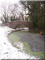
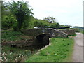
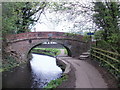
Photos of Shaftesbury Community

Area Information
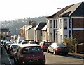
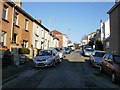
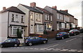
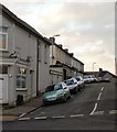
Shaftesbury Community occupies a compact footprint of just 1.8 km² within Wales. You will find a distinct separation from the typical high-density urban sprawl that characterises many modern development areas. This small unitary electoral division represents a tightly knit locality where the built environment is closely matched with its surrounding constraints. Living in Shaftesbury Community means navigating a space defined by precise geographical boundaries rather than expansive, unmanaged growth. The area is compact enough that daily movements are often contained within immediate surroundings, yet structured enough to maintain clear planning definitions. Your daily life here is shaped by this limited scale, which fosters a sense of locality that larger districts simply cannot replicate. The community serves as a specific administrative zone where residents interact with planning regulations and safety assessments frequently. Any development or change within these borders is subject to strict oversight due to the small area size. You are entering a market that values defined limits and established character over rapid expansion. The environment is not a sprawling expanse but a concentrated pocket of housing and local identity. When you consider homes in Shaftesbury Community, you are buying into a defined space where every property contributes to a singular, manageable whole. This creates a living experience focused on stability and known boundaries rather than the uncertainty of large-scale urban evolution.
- Area Type
- Parish
- Area Size
- 1.8 km²
- Population
- Not available
- Population Density
- Not available
Demographics
The people living in Shaftesbury Community reflect a clear life-stage trajectory. The median age here stands at exactly 70 years, indicating a population heavily weighted towards the elderly demographic. You will encounter an area where most residents fall into the Age: Total category without further specific breakdowns beyond this central figure. This profile suggests a community where quiet retirement fits the prevailing rhythm of daily life rather than the frenetic pace of young families. With 60% home ownership, you will find that the majority of households have built their own tenure rather than renting. This high ownership rate typically correlates with long-term stays and a settled neighbourhood character. Most people remain in one place for decades, reinforcing the stability you see in the housing stock. The high proportion of owner-occupiers means that turnover is naturally slower, creating a more static social fabric. You are looking at an area where neighbours have known each other for many years. The household composition and accommodation type data do not offer further granularity, but the overarching picture is one of stability. There is no indication of transient populations or high rental turnover. Instead, the community functions as a permanent residence for those who have chosen to settle in this specific pocket of Wales. When evaluating schools near Shaftesbury Community, you must factor in that the immediate demographic may have moved beyond typical family schooling years.
Household Size
Accommodation Type
Tenure
Ethnic Group
Religion
Household Composition
Age
Household Deprivation
NS-SEC
Explore more demographic insights in this area
Go to Demographics tabPlanning
Planning Constraints
- Flood RiskPremium
- Ramsar Wetland SitesPremium
- Area of Outstanding Natural BeautyPremium
- Protected Nature ReservePremium
- Protected WoodlandPremium
- Crime RiskPremium