Area Overview for Blaengwrach Community
Photos of Blaengwrach Community
Area Information
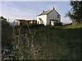
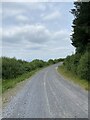
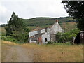
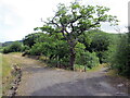
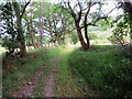
Living in Blaengwrach Community offers a quiet retreat within the Neath Valley, distinct from the busier towns nearby. This civil parish covers an area of 14.7 km² and sits on the upper reaches of the valley south of the River Neath. The landscape follows the Nant Gwrach stream, anchored by the villages of Blaengwrach and Cwmgwrach. Today, the settlement functions as a small former mining village that has transitioned from an active commercial centre servicing coalmines to a quiet rural community. You will find one shop and a single pub serving the local population of around 1,911 people. Local social life revolves around the Cwmgwrach RFC rugby club and the 13th Afannedd Scout group. While the village relies on Glynneath for wider services, the setting retains a strong sense of place. Surviving history includes St Mary's Church in Wales and the Welfare Hall, which serve as community anchors. The area carries the legacy of non-conformity from the 18th century and industrial heritage from collieries opened in the early 19th century. Residents today enjoy a pace of life defined by this rural character rather than urban energy. The absence of the former Ynys Las hunting lodge, demolished in the 1950s, marks a shift in the area's physical landscape over the last century. You can expect a residence that feels removed from congestion, situated on coordinates approximately 51.735351, -3.606552.
- Area Type
- Parish
- Area Size
- 14.7 km²
- Population
- Not available
- Population Density
- Not available
Demographics
The demographic profile of Blaengwrach Community reflects a settlement with an older age profile than the national average. The median age in the area is 70 years, placing it firmly among communities with a significantly higher proportion of elderly residents. While specific age breakdowns are not detailed in the available figures, this median age suggests a village dominated by retirees or long-term residents rather than young families or students. Home ownership stands at a solid 71%, indicating that the vast majority of households own their properties outright or have significant equity. This high rate of ownership contrasts with areas where renting dominates the housing market. The data available confirms the total household composition and total accommodation type but does not provide specific breakdowns for these categories. Consequently, you cannot determine the split between one-person households, couples, or families from the current statistics. The predominant ethnic group and religious affiliation data are similarly listed as totals without further specification. This demographic structure means the area likely appeals to those seeking a quiet retirement location rather than dynamic growth sectors. The population remained stable at around 1,911, avoiding the rapid population swings that often accompany industrial regeneration.
Household Size
Accommodation Type
Tenure
Ethnic Group
Religion
Household Composition
Age
Household Deprivation
NS-SEC
Explore more demographic insights in this area
Go to Demographics tabPlanning
Planning Constraints
- Flood RiskPremium
- Ramsar Wetland SitesPremium
- Area of Outstanding Natural BeautyPremium
- Protected Nature ReservePremium
- Protected WoodlandPremium
- Crime RiskPremium