Area Overview for Cymer and Glyncorrwg Community
Photos of Cymer and Glyncorrwg Community
Area Information
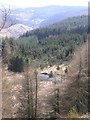
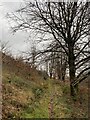
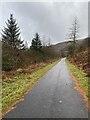
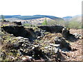
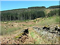
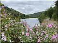
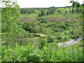
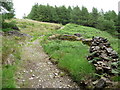
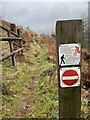
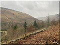
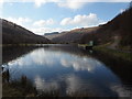
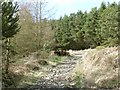
Cymer and Glyncorrwg Community stands as a distinctive rural enclave within the Afan Valley in Neath Port Talbot, Wales. This unitary electoral division spans 41.9 km², offering a landscape defined by hilly terrain and dense forests rather than urban sprawl. You will find Glyncorrwg nestled at the top of the valley, an area shaped by its industrial past but currently focused on recreation and nature. The region operates distinctly from the former coal-mining heartland it once represented, now serving as a destination for outdoor enthusiasts seeking trout fishing, canoeing, and mountain biking. Daily life here revolves around a strong sense of neighbourliness and local pride. The community has successfully transformed post-industrial sites into functional spaces, most notably through the Glyncorrwg Ponds and Mountain Bike Centre, which opened in 1990. Residents enjoy access to restored wild spaces managed under the Lost Peatlands project, which supports significant bird populations including Goshawks and Crosbills. Because the area is so focused on rural pursuits, you will not find the bustle of a city centre nearby. Instead, your day might begin with a walk along old railway trackbeds or a session on the water. This setting offers a quiet refuge where the primary attractions are natural beauty and a tight-knit social fabric rather than commercial entertainment.
- Area Type
- Parish
- Area Size
- 41.9 km²
- Population
- Not available
- Population Density
- Not available
Demographics
The population of Cymer and Glyncorrwg Community reflects a settled, mature demographic. The current median age stands at 70, indicating that the area is home to a significant number of older residents. Household composition shifts vary across the total population, though specific breakdowns for each age bracket are not detailed in the available records. Despite the high median age, the community maintains a robust level of residential stability. A substantial 72% of homes here are owner-occupied, suggesting that many families have rooted themselves deeply in the valley over time. This high rate of ownership contrasts with areas that have larger rental sectors or transient populations. You will not find data regarding the predominant ethnic group or specific religious affiliations within the community's profile. The accommodation types present also follow a general total without granular splits between flats or houses. The site does not provide information on deprivation levels or income distribution, nor does it list specific school catchment areas. Consequently, you cannot determine the exact diversity of the population or the socioeconomic stratification of the residents based on current figures. The known facts point to an established constituency where long-term ownership is the norm, driven by a population that has adapted to the rural, post-industrial character of the Upper Afan Valley.
Household Size
Accommodation Type
Tenure
Ethnic Group
Religion
Household Composition
Age
Household Deprivation
NS-SEC
Explore more demographic insights in this area
Go to Demographics tabPlanning
Planning Constraints
- Flood RiskPremium
- Ramsar Wetland SitesPremium
- Area of Outstanding Natural BeautyPremium
- Protected Nature ReservePremium
- Protected WoodlandPremium
- Crime RiskPremium