Area Overview for Trellech United Community
Photos of Trellech United Community

Area Information
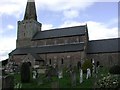
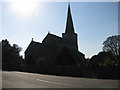
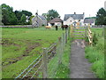
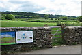
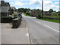
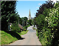
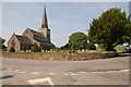
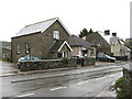
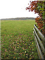
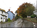
Trellech United Community sits within the historic borders of Carmarthenshire, spanning a total civil parish area of 46.4 km². This stretch of land in south Wales offers a distinctly rural character, removed from the density of larger urban centres. Living in Trellech United Community means accepting a location defined by open space rather than high-rise developments or commercial hubs. The village feels like a traditional Welsh settlement where daily life revolves around the immediate neighbourhood and the surrounding countryside. You will find a quiet pace that contrasts sharply with the fast rhythm found in major cities or coastal towns further north. The community operates as a self-contained entity where the landscape dictates the tempo of everyday activity. For those seeking a countryside retreat, the parish provides ample room without the isolation common in truly remote locations. Recent demographic trends show an older population residing within these boundaries. This shift influences the local energy and the types of services available to residents. The character of Trellech United Community remains rooted in its rural history, with a strong emphasis on home ownership rather than private renting. The area functions as a peaceful sanctuary for retirees and locals who value stability over urban convenience. When considering homes in Trellech United Community, you are entering a market where tradition holds significant sway over modern trends. The small size of the parish ensures that everyone knows everyone, fostering a tight-knit social atmosphere. This environment suits those who prefer quiet evenings and a tight community over vibrant nightlife or extensive shopping options.
- Area Type
- Parish
- Area Size
- 46.4 km²
- Population
- Not available
- Population Density
- Not available
Demographics
The population profile of Trellech United Community reflects a mature settlement with a median age of 70 years old. This figure places the average household head well into retirement or near-retirement years. Such an age distribution defines the social fabric of the parish, which skirt the constraints of typical family households. Most Common Age Range data indicates that the total population skew is heavily towards senior citizens compared to working-age cohorts. This demographic reality shapes local demand, as you will see fewer school-aged children and young professionals living in the parish. Family units with young children appear less common, which impacts the vibrancy of local playgroups and youth sports clubs. Home ownership stands at 84 per cent within the parish, a figure that suggests deep community roots and long-term settlement. Residents have typically lived in their properties for decades, contributing to a stable neighbourhood with low transient populations. The remaining 16 per cent of households, likely consisting of younger couples or tenants, represent a small minority in this established environment. Accommodation type statistics indicate that detached or semi-detached family homes dominate the stock, rather than the high-rise flats found in urban centres. This structure supports a lifestyle centred on private gardens and personal property maintenance. The section for predominant ethnic groups and religion lacks specific breakdown data, focusing instead on the clear dominance of long-term British residents. Deprivation metrics are not explicitly detailed, but the high ownership rate implies a community with significant residential stability and asset ownership rather than reliance on social housing.
Household Size
Accommodation Type
Tenure
Ethnic Group
Religion
Household Composition
Age
Household Deprivation
NS-SEC
Explore more demographic insights in this area
Go to Demographics tabPlanning
Planning Constraints
- Flood RiskPremium
- Ramsar Wetland SitesPremium
- Protected Nature ReservePremium
- Protected WoodlandPremium
- Crime RiskPremium