Area Overview for NP16 6BZ
Photos of NP16 6BZ
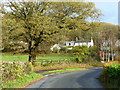
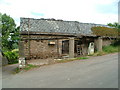
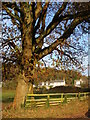
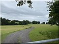
9 photos from this area
Area Information
Key information about the NP16 6BZ including its size, population, and administrative classification.
- Area Type
- Postcode
- Area Size
- 2.1 km²
- Population
- 1388
- Population Density
- 25 people/km²
House Prices in NP16 6BZ
23
Properties
£561,167
Average Sold Price
£170,000
Lowest Price
£1,000,000
Highest Price
Showing 23 properties
| Address | Type | Beds | Baths | Last Sale Price | Last Sale Date | |
|---|---|---|---|---|---|---|
| Broadview, Lane From B 4293 Itton Road To Park House, Itton Common, NP16 6BZ | Detached | 4 | 4 | £1,000,000 | Jul 2023 | |
| Sunset View, B 4293 Itton Common To Cefngarw Wood, Itton Common, NP16 6BZ | Bungalow | 3 | 1 | £690,000 | Oct 2022 | |
| Yewberry House, Itton Road, Itton, NP16 6BZ | Retail | 5 | 4 | £790,000 | Jul 2022 | |
| High Ridge, Lane From B 4293 Itton Road To Park House, Itton Common, NP16 6BZ | house | - | - | £710,000 | Jun 2021 | |
| The Ash Tree, Itton Road, Itton, NP16 6BZ | house | - | - | £535,000 | Feb 2021 | |
| Heppleshaw, Lane From B 4293 Itton Road To Park House, Itton Common, NP16 6BZ | Detached | 4 | - | £640,000 | May 2020 | |
| The Old School, Lane From B 4293 Itton Road To Park House, Itton Common, NP16 6BZ | Detached | 4 | 2 | £650,000 | Oct 2018 | |
| Woodhill, Lane From B 4293 Itton Road To Park House, Itton Common, NP16 6BZ | Bungalow | 4 | 1 | £490,000 | Jul 2016 | |
| Llainfadyn, Itton Road, Itton, NP16 6BZ | Bungalow | 4 | - | £300,000 | Feb 2014 | |
| Bath House, Itton Road, Itton, NP16 6BZ | Detached | - | - | £559,000 | Dec 2005 |
Page 1 of 3
Energy Efficiency in NP16 6BZ
Amenities
Schools
| Rank | School | Type | Entry gender | Ages |
|---|
Explore more schools in this area
Go to Schools tabDemographics
Household Size
Two person
most common
Accommodation Type
Houses
most common
Tenure
85
majority
Ethnic Group
White
most common
Religion
N/A
most common
Household Composition
N/A
most common
Age
47
median
Adults (30-64 years)
most common
Household Deprivation
N/A
with no deprivation
NS-SEC
49
in Lower managerial occupations
Explore more demographic insights in this area
Go to Demographics tabPlanning
Planning Constraints
- Flood RiskPremium
- Ramsar Wetland SitesPremium
- Protected Nature ReservePremium
- Protected WoodlandPremium
- Crime RiskPremium