Area Overview for Mitchel Troy Community
Photos of Mitchel Troy Community


Area Information
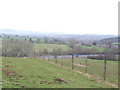
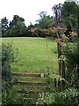
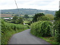
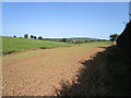
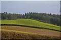
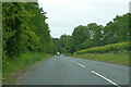
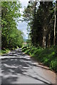
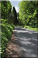
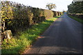
Mitchel Troy Community is a civil parish in Wales covering an extensive 56.5 km². You will find yourself in a distinctive rural setting where space defines daily life. The landscape includes significant protected areas, such as land within the Area of Outstanding Natural Beauty and sections of designated nature reserves. This large footprint means quiet roads and spacious plots are common for those considering homes in Mitchel Troy Community. The area represents a specific moment in Welsh rural history, with a median age of 70 years. This demographic reality shapes the character of the parish entirely. There is no younger, transient crowd seeking nightlife; instead, life revolves around established residents deeply connected to the land. You cannot expect the rapid pace found in urban centres here. The environment attracts those seeking stability, proximity to heritage sites, and a slower rhythm outside the major population hubs. Living in Mitchel Troy Community offers a direct engagement with the natural environment. You are surrounded by protected woodland and wildlife corridors. The parish lacks the infrastructure density of larger towns, which underlines its rural purpose. While this isolation suits some, it requires an acceptance of distance from commercial amenities. The region remains a static, traditional community. Your day-to-day experience will be dictated by the pace of the countryside and the deep-rooted nature of the village life that persists across this expansive parcel of land.
- Area Type
- Parish
- Area Size
- 56.5 km²
- Population
- Not available
- Population Density
- Not available
Demographics
The community in Mitchel Troy Community is defined almost exclusively by its elderly population. The median age is 70 years, indicating that nearly half the residents are over this mark. You will encounter very few families with young children or working-age adults in the typical sense. This age profile creates a localized culture focused on retirement and established routines. Home ownership stands at a robust 77 per cent within the parish. This high figure reflects the settled nature of the population and the historical cost of property in rural Wales. The remaining 23 per cent of households are likely older occupants renting locally or living in social housing. There is no data regarding specific household composition breakdowns beyond the total, nor is there information on the predominant ethnic group or religious affiliation recorded in the available statistics. Deprivation metrics are not provided for this specific area, so any assessment of economic disadvantage must rely on the visible demographic profile. The absence of a young working population often correlates with lower economic dynamism in such villages. However, the high rate of ownership suggests financial stability for the majority of current residents. When planning to move to Mitchel Troy Community, you should anticipate a society where wealth has been accumulated over decades, and where land ownership passes directly between generations of older adults.
Household Size
Accommodation Type
Tenure
Ethnic Group
Religion
Household Composition
Age
Household Deprivation
NS-SEC
Explore more demographic insights in this area
Go to Demographics tabPlanning
Planning Constraints
- Flood RiskPremium
- Ramsar Wetland SitesPremium
- Area of Outstanding Natural BeautyPremium
- Protected Nature ReservePremium
- Protected WoodlandPremium
- Crime RiskPremium