Area Overview for Crucorney Community
Photos of Crucorney Community
Area Information
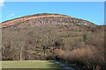
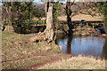
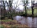
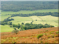
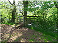
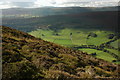
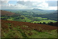
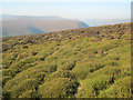
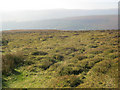
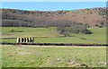
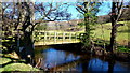
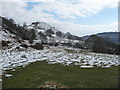
Living in Crucorney Community offers a distinct experience within the parish of Crucorney, which spans an impressive 70.9 square kilometres across Wales. This large civil parish provides ample space for residents to enjoy a wide variety of landscapes without the density found in towns. The area feels expansive, allowing you to drive considerable distances between local points of interest. This substantial size is a defining characteristic that shapes your daily life, offering room to grow while maintaining essential connections to the wider region. The community operates as a true rural settlement where pace is controlled by the environment rather than traffic lights. You will find that daily life revolves around access to the open spaces this footprint provides. The scale of the parish ensures that green corridors run through much of the territory, giving residents immediate access to nature. While the land is vast, the population is concentrated in specific settlements, creating a manageable neighbourhood feel. Prospective buyers should note that Crucorney Community functions as a self-contained parish with its own identity. The geography dictates a slower lifestyle, which many welcome but others may find limiting if they seek bustling town centres within the parish boundaries. Your experience here will depend heavily on your commitment to exploring the 70.9 square kilometre expanse on foot or by vehicle. The area stands apart from urban developments, prioritising openness and space.
- Area Type
- Parish
- Area Size
- 70.9 km²
- Population
- Not available
- Population Density
- Not available
Demographics
The community profile of Crucorney Community tells a clear story of an older population. The median age sits at 70 years, indicating that the area is predominantly inhabited by senior residents. You will not find clusters of young professionals or families with infants in significant numbers here. The most common age range covers the total population, reflecting this broad shift towards later life. Home ownership stands at 82 per cent, which is exceptionally high for any region in the UK. This figure confirms that the vast majority of residents own their homes outright or with significant equity. Very few people rely on the rental market to secure housing in this parish. The dominance of owner-occupied properties creates a sense of stability and long-term settlement within Crucorney Community. Accommodation types and household composition reflect this demographic reality. The data shows that total household composition aligns with the needs of an ageing society. You are unlikely to encounter the high-density apartment blocks typical of cities. Instead, the mix likely consists of detached or semi-detached family homes adapted for older living. The predominant ethnic group and specific religious breakdowns remain generalised in the total figures provided. This demographic structure suggests a quiet environment where neighbours know each other well across generations. Life here moves at a pace suited to retirees and those seeking peace rather than urban excitement. The high ownership rate means fewer tenants and generally more consistent maintenance of the housing stock.
Household Size
Accommodation Type
Tenure
Ethnic Group
Religion
Household Composition
Age
Household Deprivation
NS-SEC
Explore more demographic insights in this area
Go to Demographics tabPlanning
Planning Constraints
- Flood RiskPremium
- Ramsar Wetland SitesPremium
- Area of Outstanding Natural BeautyPremium
- Protected Nature ReservePremium
- Protected WoodlandPremium
- Crime RiskPremium