Area Overview for CF48 2DH
Photos of CF48 2DH


Area Information
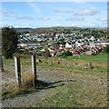
CF48 2DH represents a specific residential cluster within the wider community of Pant, located in the Merthyr Tydfil County Borough of South Wales. This small area covers an extent of 7,325 square metres and houses a population of approximately 1,510 residents. You are stepping into a neighbourhood defined by its history and compact scale. Early maps describe the region as thinly populated, originally featuring farms such as Caeracca and Pantyscallog near Dowlais. The land currently holds the postcode CF48 2DH and sits amidst ruins including Morlais Castle, which dates back to around 1265. The area saw significant developments in the nineteenth century, including the opening of Pant Cemetery in 1849 following a cholera outbreak. Christ Church was constructed in the 1870s to serve the parish. Although a railway station once served the location before closing in 1960, the location remains rooted in this industrial heritage. Today, the postcode defines a tight-knit living environment where every street is part of a clearly bounded community. Living in this postcode means accessing a space that balances historical significance with modern residential use. The density here is high relative to the land size, creating an intimate atmosphere distinct from the broader rural valleys. You will find yourself in a place where the past is physically present alongside daily life.
- Area Type
- Postcode
- Area Size
- 7325 m²
- Population
- 1510
- Population Density
- 1570 people/km²
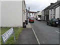
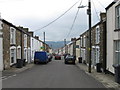
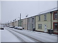
The property market in the CF48 2DH postcode is characterised by a stock dominated by houses. With a population of 1,510 spread across 7,325 square metres, the housing density is significant for such a small area. Home ownership accounts for 49% of households, suggesting that a slightly smaller portion of the market consists of renters. When evaluating homes in this postcode, you should expect to find traditional detached or semi-detached houses rather than apartment-style accommodation. This area does not contain flats, which limits your choices to properties with gardens and private outdoor space. The 49% home ownership rate indicates that many residents have secured their own homes, while the remainder rely on the rental sector. For buyers looking at this specific cluster, the market operates on a small scale where local knowledge is vital. The area includes notable historical sites like Morlais Castle and Pant Cemetery, which may influence property values in adjacent streets. The lack of high-rise buildings or modern conversion schemes means the architectural style remains consistent. You are purchasing a piece of history within the Pant parish, where the built environment reflects centuries of local development. The housing stock is devoid of protected woodland or Ramsar wetland sites, simplifying planning considerations for extensions or renovations.
House Prices in CF48 2DH
Showing 25 properties
| Address | Type | Beds | Baths | Last Sale Price | Last Sale Date | |
|---|---|---|---|---|---|---|
| 6 Heol Y Bryniau, Pant, Merthyr Tydfil, CF48 2DH | Semi-detached | 3 | 1 | £180,000 | May 2024 | |
| 8 Heol Y Bryniau, Pant, Merthyr Tydfil, CF48 2DH | house | - | - | £70,000 | Aug 2022 | |
| 1 Heol Y Bryniau, Pant, Merthyr Tydfil, CF48 2DH | Semi-detached | 3 | 1 | £85,000 | Oct 2020 | |
| 9 Heol Y Bryniau, Pant, Merthyr Tydfil, CF48 2DH | house | - | - | £75,000 | Nov 2018 | |
| 27 Heddwch Close, Pant, Merthyr Tydfil, CF48 2DH | undefined | - | - | - | - | |
| 31 Heddwch Close, Pant, Merthyr Tydfil, CF48 2DH | undefined | - | - | - | - | |
| 23 Heddwch Close, Pant, Merthyr Tydfil, CF48 2DH | undefined | - | - | - | - | |
| 22 Heddwch Close, Pant, Merthyr Tydfil, CF48 2DH | undefined | - | - | - | - | |
| 24 Heddwch Close, Pant, Merthyr Tydfil, CF48 2DH | undefined | - | - | - | - | |
| 26 Heddwch Close, Pant, Merthyr Tydfil, CF48 2DH | undefined | - | - | - | - |
Energy Efficiency in CF48 2DH
Your daily lifestyle in CF48 2DH revolves around a selection of nearby amenities that serve the local community effectively. Retail options are concentrated just outside the immediate cluster, including Asda Merthyr, Lidl Dowlais, and Spar. These five retail outlets cover major shopping needs without requiring a long commute. For rail travel, you have access to five stations in the vicinity, including Merthyr Tydfil Railway Station, Rhymney Railway Station, and Pentre. These facilities connect you to the wider region efficiently. The area of CF48 2DH spans 7,325 square metres and supports a population of 1,510, meaning these amenities serve a manageable group of people. Historical landmarks like Christ Church, built in the 1870s, and Pant Cemetery, opened in 1849, offer cultural points of interest close to home. The presence of these sites adds character to your everyday walks. You will find that your routine involves stopping at Spar for essentials or visiting the larger supermarkets in Dowlais for bulk shopping. The rail stations provide a direct link to work or leisure destinations. Living in this postcode means balancing the quiet of a historic farm settlement with the convenience of nearby shopping and transport hubs.
Amenities
Schools
| Rank | School | Type | Entry gender | Ages |
|---|
Explore more schools in this area
Go to Schools tabDemographics
The community within the CF48 2DH postcode area reflects a mature demographic profile with a median age of 47 years. Most residents fall into the adult age range between 30 and 64 years, indicating a population of working families and established households rather than young professionals or retirees. With a total population of 1,510, this area maintains a steady community size. Home ownership stands at 49%, meaning nearly half of the households own their property outright. This figure suggests a balanced market where investment buyers and long-term owners mix, though no specific data distinguishes between these groups. Houses form the primary accommodation type, confirming that you will be looking for detached or semi-detached properties rather than flats. The predominant ethnic group is White, which aligns with the broader demographic trends of the Merthyr Tydfil region. You will find living in this area involves engaging with a community that has a clear generational character. High population density, recorded at 206,141 people per square kilometre based on the 7,325 square metre area size, indicates that homes are situated relatively close together. This density fosters a neighbourhood feel where residents interact frequently. The demographic data paints a picture of a stable, established community rather than a rapidly changing development zone.
Household Size
Accommodation Type
Tenure
Ethnic Group
Religion
Household Composition
Age
Household Deprivation
NS-SEC
Explore more demographic insights in this area
Go to Demographics tabPlanning
Planning Constraints
- Flood RiskPremium
- Ramsar Wetland SitesPremium
- Area of Outstanding Natural BeautyPremium
- Protected Nature ReservePremium
- Protected WoodlandPremium
- Crime RiskPremium