Area Overview for Rhoscolyn Community
Photos of Rhoscolyn Community


Area Information
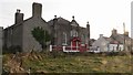
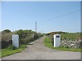
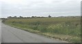
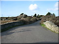
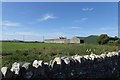
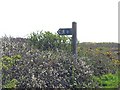
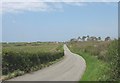
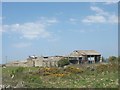
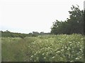
Rhoscolyn Community stands as a distinct civil parish covering an area of 10.5 km² on the Isle of Anglesey in Wales. This small, defined territory offers a grounded rural experience rather than the sprawling hustle of larger towns. Living in Rhoscolyn Community means you inhabit a space where the scale of your immediate neighbours is measured in hectares and square kilometres, creating a sense of isolation from urban centres. The local landscape is heavily influenced by its inclusion within an Area of Outstanding Natural Beauty, a status that commands strict planning restrictions to preserve the visual character of the valley. You will find yourself surrounded by protected woodlands, which further limit development potential and maintain the parish's quiet, green identity. The daily rhythm here follows the pace of a community with a median age of 70. Life revolves around established local landmarks and a population that has matured alongside the region. While specific town centres or major retail parks are absent from the description provided, the area functions as a self-contained residential sphere bounded by significant environmental designations. Ownership here is high, suggesting a settled population with deep roots in the 73% ownership rate. When looking at homes in Rhoscolyn Community, you are buying into a legacy landscape where natural beauty dictates the layout of every street and garden. The parish avoids the zoning debates of larger municipalities, offering a straightforward, albeit restricted, residential environment.
- Area Type
- Parish
- Area Size
- 10.5 km²
- Population
- Not available
- Population Density
- Not available
Demographics
The demographic profile of Rhoscolyn Community reflects a very mature society. With a median age of 70, this parish is home to a population significantly older than the national average. You are looking at an area where the average resident is two decades into retirement life or beyond. Age data confirms that the total population skews heavily towards older individuals, meaning that active young families or students are a minority presence in this specific civil parish. This age structure shapes the local demand, prioritising accessibility and quiet over energy-intensive amenities. High home ownership levels of 73% reinforce the stability of this age group, as residents in Rhoscolyn Community tend to own their properties outright rather than renting. Household composition in this parish does not suggest large, multi-generational families. Instead, the data points to smaller domestic units consistent with retired couples or older singles. The accommodation type total available does not highlight student mitigations or shared living, further supporting the conclusion of a retirement-focused zone. Diversity metrics are not explicitly detailed in the available figures, but the high concentration of older residents generally correlates with more homogenous, long-term settlement patterns. When evaluating quality of life through a demographic lens, Rhoscolyn Community offers a peaceful setting suitable for those who value silence and established neighbourhoods. The absence of young people in large numbers means you will not hear evening noise issues common in university towns or major urban centres. Every aspect of the community design caters to the needs of those in their later years.
Household Size
Accommodation Type
Tenure
Ethnic Group
Religion
Household Composition
Age
Household Deprivation
NS-SEC
Explore more demographic insights in this area
Go to Demographics tabPlanning
Planning Constraints
- Flood RiskPremium
- Ramsar Wetland SitesPremium
- Area of Outstanding Natural BeautyPremium
- Protected Nature ReservePremium
- Protected WoodlandPremium
- Crime RiskPremium