Area Overview for Holyhead Community
Photos of Holyhead Community


Area Information
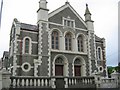
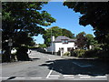
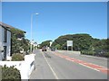
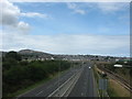
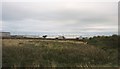
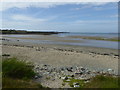
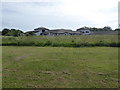
Living in Holyhead Community offers a unique coastal existence within the civil parish of Holy Island in north-west Wales. You reside in a location covering 10.7 square kilometres with a population of 1,609 residents. This area forms part of the town of Holyhead, historically known as Caergybi, and sits just off the west coast of the Isle of Anglesey facing the Irish Sea. The community has deep roots, with settlement evidence dating back to the Neolithic and early Bronze Age. You stand among ancient megalithic burial chambers and standing stones while looking out toward the water. Historically, the area was defined as the Holyhead Urban District until 1974, when it was reconstituted as a community under the Borough Council, which later became a county council. Today, the landscape is shaped by maritime history, including the remains of the Roman fort Caer Gybi and the UK's longest breakwater built in the mid-19th century. Daily life here involves proximity to the major ferry port serving Ireland and connections via the Chester-Holyhead railway. The presence of South Stack lighthouse, constructed in 1809, reminds residents of the area's enduring relationship with the sea. You enjoy a setting where heritage trails highlight the industrial and maritime past, blending ancient history with modern connectivity.
- Area Type
- Parish
- Area Size
- 10.7 km²
- Population
- 1609
- Population Density
- 150 people/km²
Demographics
The people of Holyhead Community are drawn from an older demographic profile. The median age in this parish stands at 70 years. This figure indicates a population significantly skewed toward retirees and long-term residents rather than young families or workers. There is no specific breakdown of the most common age range in the current data, but the median figure clearly defines the community's character. Regarding how people live, 59% of households own their homes outright. This majority ownership rate suggests a stable population with strong ties to the local area, complementing the historical context of this being a former urban district. The remaining 41% house others through various forms of tenancy. Data on accommodation types, household composition, ethnicity, and religion is not currently available in the provided records. Consequently, you cannot make specific claims about the diversity of cultural backgrounds or the mix of family-sized homes versus single occupancy units. You should anticipate a quiet environment where daily interactions likely involve neighbours who have lived here for decades. The high home ownership percentage often correlates with areas where residents value stability and permanence over transient city living. Understanding this age profile helps you comprehend the pace of life and the types of services typically needed in the parish.
Household Size
Accommodation Type
Tenure
Ethnic Group
Religion
Household Composition
Age
Household Deprivation
NS-SEC
Explore more demographic insights in this area
Go to Demographics tabPlanning
Planning Constraints
- Flood RiskPremium
- Ramsar Wetland SitesPremium
- Area of Outstanding Natural BeautyPremium
- Protected Nature ReservePremium
- Protected WoodlandPremium
- Crime RiskPremium