Area Overview for LL55 4LS
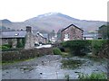
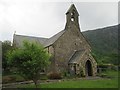
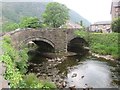
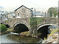
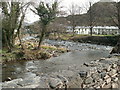
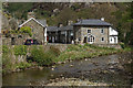
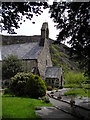
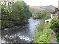
Photos of LL55 4LS

Area Information
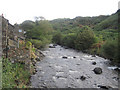
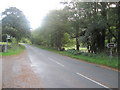
LL55 4LS is a small residential postcode in Wales, home to 1,196 people spread across a low-density area of just 12 people per square kilometre. This suggests a quiet, rural or semi-rural setting, likely with spacious properties and a close-knit community. The area’s character is defined by its modest size and the prevalence of owner-occupied homes. With a median age of 47, the population skews towards middle-aged adults, many of whom may have established careers and families. Daily life here is likely to revolve around local amenities, such as nearby railway stations and retail outlets, while the surrounding landscape offers a peaceful backdrop. The absence of major planning constraints or environmental risks means residents can enjoy a stable, low-stress environment. For those seeking a quiet, self-contained lifestyle with access to essential services, LL55 4LS presents a straightforward option, though its small size means it’s not suited to those requiring a broader range of facilities.
- Area Type
- Postcode
- Area Size
- Not available
- Population
- 1196
- Population Density
- 12 people/km²
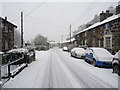
The property market in LL55 4LS is characterised by a high rate of home ownership, with 66% of residents owning their homes. The accommodation type is predominantly houses, indicating a lack of rental properties or flats. This suggests a market primarily catering to owner-occupiers rather than tenants, which may limit availability for buyers seeking alternative housing types. The small size of the area means the housing stock is limited, and the focus on single-family homes could appeal to those prioritising space and privacy. However, the lack of diversity in property types may pose challenges for buyers with specific needs, such as those requiring larger homes or investment opportunities. Given the low population density, properties here are likely to be spacious, though the limited number of homes means the market is not highly competitive.
House Prices in LL55 4LS
No properties found in this postcode.
Energy Efficiency in LL55 4LS
Residents of LL55 4LS have access to a range of local amenities, including five retail outlets such as Spar and Tesco Porthmadog, which provide essential shopping needs. The nearby metro areas of Beddgelert, Nantmor, and Rhyd Ddu likely offer additional services, though specific details on parks or leisure facilities are not provided. The five rail stations, including Tan and Porthmadog Railway Station, connect the area to broader networks, facilitating travel to larger towns. While the data does not specify leisure options, the proximity to railway stations and retail hubs suggests a lifestyle that balances local convenience with regional accessibility. The character of the area appears to prioritise practicality, with amenities focused on daily essentials rather than extensive recreational facilities.
Amenities
Schools
The nearest school to LL55 4LS is Ysgol Gynradd Beddgelert, which is categorised as an "other" type. No further details on its Ofsted rating or curriculum are provided, so its quality remains unspecified. As the only listed school in the area, families may need to consider additional options beyond LL55 4LS for a broader range of educational choices. The presence of a single school suggests that parents might need to travel to nearby towns for secondary education or specialist provisions. While the school’s type is not defined, its existence indicates a basic level of educational infrastructure. For families prioritising proximity to schools, this could be a factor, though the lack of data on performance or capacity means further research would be necessary.
| Rank | School | Type | Entry gender | Ages |
|---|
Explore more schools in this area
Go to Schools tabDemographics
The community in LL55 4LS is predominantly composed of adults aged 30–64, with a median age of 47. This suggests a mature, stable population, likely with strong ties to the area. Home ownership is high, at 66%, with the majority of properties being houses rather than flats or apartments. The predominant ethnic group is White, though no specific diversity metrics are provided. The low population density of 12 people per square kilometre indicates a spread-out settlement, possibly with larger plots of land. While no data on deprivation is available, the high home ownership rate and age profile suggest a community focused on long-term residency rather than transient populations. This demographic profile aligns with a lifestyle that values privacy, space, and local connections over urban amenities.
Household Size
Accommodation Type
Tenure
Ethnic Group
Religion
Household Composition
Age
Household Deprivation
NS-SEC
Explore more demographic insights in this area
Go to Demographics tabPlanning
Planning Constraints
- Flood RiskPremium
- Ramsar Wetland SitesPremium
- Area of Outstanding Natural BeautyPremium
- Protected Nature ReservePremium
- Protected WoodlandPremium
- Crime RiskPremium