Area Overview for LL36 9WY
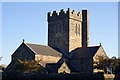
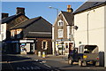
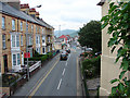
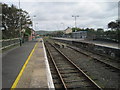
Photos of LL36 9WY


Area Information
Living in LL36 9WY means being part of a small, tightly knit community in north Wales. With a population of 1,464 spread across a residential cluster, the area has a density of 500 people per square kilometre, suggesting a balance between space and proximity. The postcode sits in a region where daily life revolves around local amenities and natural surroundings. Residents benefit from nearby rail links, including Tywyn and Aberdovey stations, which connect to broader networks. The area’s character is shaped by its modest scale, with homes predominantly in single-family units. While it lacks large urban hubs, the proximity to towns like Tywyn and Rhydyronen offers access to shops, services, and cultural activities. The community is largely composed of middle-aged adults, reflecting a stable demographic profile. For those seeking a quiet, manageable living environment with practical transport options, LL36 9WY offers a straightforward, unpretentious lifestyle.
- Area Type
- Postcode
- Area Size
- Not available
- Population
- 1464
- Population Density
- 500 people/km²
The property market in LL36 9WY is defined by its low density and focus on single-family homes. With 49% of properties owner-occupied, the area is not dominated by rental stock but still has a significant proportion of tenants. The predominance of houses suggests a market tailored to families or individuals seeking space, though the small size of the postcode means the housing stock is limited. Buyers should consider the area’s constraints: the lack of large-scale developments or high-end properties makes it a niche market. Proximity to rail stations and nearby towns like Tywyn may enhance its appeal for commuters. However, the small footprint of LL36 9WY means property choices are restricted to a handful of homes, requiring buyers to assess the value of the location against the limited supply.
House Prices in LL36 9WY
No properties found in this postcode.
Energy Efficiency in LL36 9WY
The lifestyle in LL36 9WY is shaped by its proximity to essential amenities. Within practical reach are five metro areas, including Tywyn Pendre and Rhydyronen, which likely offer retail, leisure, and service options. Local shops such as Spar and Co-op Tywyn provide basic grocery needs, while the rail stations connect to broader networks for dining, shopping, and entertainment. The area’s small scale means daily life is centred on nearby hubs, with a focus on convenience over large-scale facilities. The combination of rail access and local retail ensures residents can manage routine tasks without long commutes. While the amenities are modest, they reflect the area’s practical, community-oriented character.
Amenities
Schools
The nearest school to LL36 9WY is Ysgol Uwchradd Tywyn, categorised as an ‘other’ school. While no Ofsted rating is provided, its presence indicates access to local education infrastructure. The school type suggests it may serve a specific age group or educational need, though details are sparse. Families relying on this school should consider its proximity and whether it meets their child’s requirements. The absence of additional schools in the data means the area’s educational options are limited to this single institution. For parents seeking a range of school types, such as primary, secondary, or specialist provisions, further research beyond the immediate postcode would be necessary.
| Rank | School | Type | Entry gender | Ages |
|---|---|---|---|---|
| 1 | Ysgol Uwchradd Tywyn | other | N/A | N/A |
Explore more schools in this area
Go to Schools tabDemographics
The population of LL36 9WY has a median age of 47, with the majority of residents aged between 30 and 64. This suggests a community centred on established adults, likely with families or long-term tenure in the area. Home ownership stands at 49%, meaning nearly half of properties are rented, indicating a mix of owner-occupied and rental housing. The predominant accommodation type is houses, which aligns with the area’s residential character. The predominant ethnic group is White, reflecting the broader demographic patterns of rural Wales. While no specific data on deprivation or diversity is provided, the age profile and home ownership rate imply a stable, low-turnover population. The absence of detailed socioeconomic breakdowns means the area’s quality of life remains tied to its practical amenities and quiet surroundings.
Household Size
Accommodation Type
Tenure
Ethnic Group
Religion
Household Composition
Age
Household Deprivation
NS-SEC
Explore more demographic insights in this area
Go to Demographics tabPlanning
Planning Constraints
- Flood RiskPremium
- Ramsar Wetland SitesPremium
- Area of Outstanding Natural BeautyPremium
- Protected Nature ReservePremium
- Protected WoodlandPremium
- Crime RiskPremium