Area Overview for Arthog Community
Photos of Arthog Community
Area Information
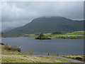
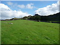
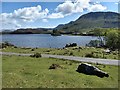
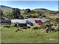
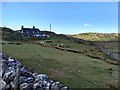
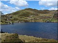
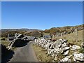
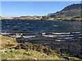
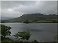
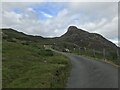
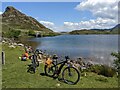
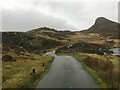
Arthog Community is a rural civil parish in Wales covering 42.7 square kilometres. Living here means embracing a wide-open landscape where nature dictates the daily rhythm. The parish is sparse compared to urban centres, offering residents a quiet environment far removed from the noise of the city. Daily life revolves around the local distinctiveness of the area rather than a high-density amenity mix. You will not find a shopping district or a bustling high street within the parish boundaries. Instead, your routine involves accessible country roads and direct exposure to the natural world. The sheer size of the parish allows you to enjoy complete seclusion without leaving the area entirely. Residents here value space and tranquility above metropolitan convenience. Living in Arthog Community requires acceptance of travel time for work or goods, as local infrastructure is limited to the essentials. The setting is defined by its agricultural and natural character rather than commercial development. This is a place for those seeking a definition of home centred on liberty and open skies. You must consider whether your lifestyle aligns with a location where the nearest major services lie at a significant distance. The parish offers a specific type of Welsh rural existence that is unfiltered by modern urban pressures.
- Area Type
- Parish
- Area Size
- 42.7 km²
- Population
- Not available
- Population Density
- Not available
Demographics
The community profile of Arthog Community tells a story of a settled, older population. The median age reaches 70 years, meaning half the residents are older than this mark. This indicates that the parish appeals strongly to retirees who have moved into the area for its peace. The most common demographic data provided simply categorises the total population age range, reinforcing the general older skew. Homeownership stands at 75 per cent, which is high compared to national rentals markets. This suggests that most people own their properties outright rather than renting from a landlord. Accommodation type data is limited in the provided figures, but the high ownership rate implies a housing stock dominated by single-family detached homes. With 75 per cent of households owning their homes, you can expect to see fewer temporary rental listings than in a student town. The household composition is best understood as stable and established, with less turnover than in a commuter belt village. Deprivation indicators are absent from the specific data available for this parish, so you must rely on the age and ownership figures to infer the economic landscape. A 70-year-old median age often correlates with fixed incomes and established equity in a historic rural area. Dark data points are missing from the ethnic and religious breakdown, but the demographic picture remains dominated by the Welsh rural population pattern. The 75 per cent ownership figure is a concrete fact defining the social fabric. It signals a community where people put down roots and stay for the long term. Those considering moving to Arthog Community should prepare for an environment designed for older, property-owning residents.
Household Size
Accommodation Type
Tenure
Ethnic Group
Religion
Household Composition
Age
Household Deprivation
NS-SEC
Explore more demographic insights in this area
Go to Demographics tabPlanning
Planning Constraints
- Flood RiskPremium
- Ramsar Wetland SitesPremium
- Area of Outstanding Natural BeautyPremium
- Protected Nature ReservePremium
- Protected WoodlandPremium
- Crime RiskPremium