Area Overview for Dolbenmaen Community
Photos of Dolbenmaen Community
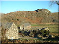
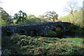

![Farmland at Llanfihangel y Pennant [1] in Dolbenmaen Community](https://images.propbar.co.uk/images/geograph/45/09/4509735_120.jpg)


Area Information
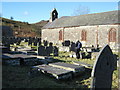
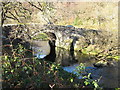
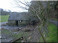
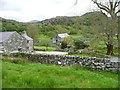
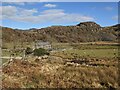
Dolbenmaen Community is a large civil parish in Gwynedd, Wales, covering an expanse of 96.4 square kilometres. This rural area functions as the administrative heart of the historic Eifionydd region, centred around the village of Dolbenmaen. The settlement holds deep historical significance, having served as a royal administrative centre known as a bond township before its status shifted to Criccieth in the 1230s. Today, the landscape still bears visible marks of this past, including the motte south of the village which once guarded a key ford. The parish encompasses numerous villages and hamlets such as Garndolbenmaen, Bryncir, Bwlch-derwin, and Pentrefelin, creating a dispersed living pattern typical of the region. Life in Dolbenmaen Community offers a connection to an area with Neolithic and Bronze Age origins, where ancient sites like Craig-y-Tyddyn Camp and Castell Caerau dot the countryside. The most significant landmark is St Mary's Church, a Grade II* listed building with 15th-century origins that anchors the local community. You will find historic assets like the Pont Dolbenmaen bridge and the building known as Plas Dolbenmaen within this conservation area. While the community includes small settlements like the hamlet of Prenteg, the largest population hub remains Dolbenmaen itself. Living in this parish means settling into a place where history is not just recorded but physically present around you. The area is defined by its open spaces and its position as a gateway to the Eifionydd Peninsula, offering residents a quiet life rooted in centuries of local heritage.
- Area Type
- Parish
- Area Size
- 96.4 km²
- Population
- Not available
- Population Density
- Not available
Demographics
The population profile of Dolbenmaen Community reveals a village defined by an older demographic. The median age stands at 70 years, making this one of the oldest settlements in the region. This age structure suggests a community where daily life moves at a slower pace compared to urban centres. You are joining a population where life stages are heavily concentrated in later years, which naturally influences the pace of daily interactions and local events. Home ownership is the standard of residence here, with figures showing that 69 per cent of households own their property outright. This high rate of ownership indicates deep roots and long-term stability within the parish. Households in Dolbenmaen Community are predominantly composed of single-person or older couples, which aligns with the advanced median age of 70. Diversity in ethnic make-up and accommodation types remains relatively uniform due to the small, rural scale of the parish. The vibe is not one of rapid change but of continuity. For anyone considering homes in Dolbenmaen Community, it is a location that appeals to those who prioritise quiet neighbourhoods and established communities over high density. The lack of younger families or transient populations means social circles tend to be stable and local. If you value a setting where neighbours have lived for decades, this area reflects that structure clearly in its demographic makeup.
Household Size
Accommodation Type
Tenure
Ethnic Group
Religion
Household Composition
Age
Household Deprivation
NS-SEC
Explore more demographic insights in this area
Go to Demographics tabPlanning
Planning Constraints
- Flood RiskPremium
- Ramsar Wetland SitesPremium
- Area of Outstanding Natural BeautyPremium
- Protected Nature ReservePremium
- Protected WoodlandPremium
- Crime RiskPremium