Area Overview for Barmouth Community
Photos of Barmouth Community


Area Information
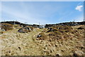
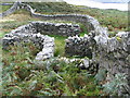
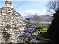
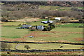
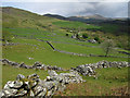
Barmouth Community sits on the estuary of the River Mawddach in Gwynedd, Wales, covering a total land area of 20.1 square kilometres. This civil parish functions as a small seaport town that evolved from a medieval fishing port into a Victorian seaside resort. The Welsh name, Abermaw, reflects its geographical position at the mouth of the river, connecting it to a heritage spanning from the Bronze Age to the modern era. Residential life here is defined by a deep connection to the coastline and a history rooted in shipbuilding and wool exports. The town has developed from its ancient roots as a community with just four houses in 1565 to a more established settlement today. Living in Barmouth Community offers proximity to historic landmarks such as Dinas Oleu and Tŷ Gwyn on the Quay, which serve as tangible links to the town's past. The landscape includes protected nature reserves and protected woodland, shaping the visual character of the area. For those considering homes in Barmouth Community, the environment provides a coastal setting distinct from the industrial aesthetics of the town's shipbuilding history. Daily life revolves around the quiet rhythm of the estuary and the preservation efforts evident in sites gifted to the National Trust.
- Area Type
- Parish
- Area Size
- 20.1 km²
- Population
- Not available
- Population Density
- Not available
Demographics
The demographic profile of Barmouth Community suggests a settled, mature population. The median age within the parish is 70, placing it among the oldest homebuyer populations in the UK. This age structure indicates a community where retirees and older residents form the central demographic group. Historical records show the Parish of Llanaber listed over 100 taxpayers as early as 1292, establishing long-term residency patterns that persist today. Regarding housing tenure, home ownership accounts for 57% of households, while the remainder are likely rented properties. This majority owner-occupier status points towards stability within the community rather than a transient rental market. Data regarding specific household composition, predominant ethnic groups, and religious affiliation is not detailed in the local records, but the high home ownership rate often correlates with long-term residents who have invested in their localities. The population's age implies a demand for housing suited to older lifestyles, potentially influencing the types of homes that retain value or are renovated. Understanding who lives here helps prospective buyers gauge the social atmosphere of living in Barmouth Community.
Household Size
Accommodation Type
Tenure
Ethnic Group
Religion
Household Composition
Age
Household Deprivation
NS-SEC
Explore more demographic insights in this area
Go to Demographics tabPlanning
Planning Constraints
- Flood RiskPremium
- Ramsar Wetland SitesPremium
- Area of Outstanding Natural BeautyPremium
- Protected Nature ReservePremium
- Protected WoodlandPremium
- Crime RiskPremium