Area Overview for Northop Community
Photos of Northop Community


Area Information
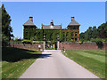
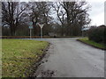
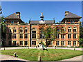
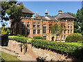
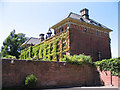
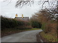
Living in Northop Community offers a distinct rural experience within Flintshire, North East Wales. This civil parish covers an area of 11.4 km² and sits approximately 12 miles west of Chester. The village is defined by its strategic position on ancient Roman and medieval routeways, currently located just off junction 33 of the A55 North Wales Expressway. You will find yourself midway between the towns of Mold and Flint, providing easy access to wider amenities while maintaining a secluded character. The local population is approximately 1,600, centred around Northop Hall, with the parish extending to include Sychdyn. The area retains a historical identity shaped by past lead extraction, trade routes for wool, and pilgrimages to Holywell. Despite post-war estate expansion in the 1960s, Northop maintains an essentially rural character dominated by historic roads and its prominent church tower. The environment is marked by well-preserved sections of the 8th-century Wat's Dyke and traditional structures like the 18th-century tollgate within the churchyard. Daily life here involves a quiet, community-focused rhythm rooted in over a millennium of history, rather than the fast pace of nearby urban centres.
- Area Type
- Parish
- Area Size
- 11.4 km²
- Population
- Not available
- Population Density
- Not available
Demographics
The demographic profile of Northop Community reveals a settled, mature population. The median age stands at 70 years, indicating a community dominated by older residents. Households are primarily comprised of individuals living alone, reflecting the age structure of the area. You will find that 84% of homes are owner-occupied, suggesting high levels of stability and deep local roots. The remaining 16% of households are rented properties. The parish shows a predominantly ethnic group composition consistent with the wider Welsh population, without significant recent migration clusters. Religious affiliation follows the broader regional patterns typical of rural Wales. While specific data on socioeconomic deprivation is not provided, the high rate of home ownership and older age profile suggest a stable, lower-density living environment. Residents here are likely to be deeply embedded in local institutions, given the lengthy history of settlement dating back to the Saxon surrender of Chester circa AD 828. The most common age group covers the total population boundary, reinforcing that there are very few young families or transient workers compared to the resident elderly population.
Household Size
Accommodation Type
Tenure
Ethnic Group
Religion
Household Composition
Age
Household Deprivation
NS-SEC
Explore more demographic insights in this area
Go to Demographics tabPlanning
Planning Constraints
- Flood RiskPremium
- Ramsar Wetland SitesPremium
- Area of Outstanding Natural BeautyPremium
- Protected Nature ReservePremium
- Protected WoodlandPremium
- Crime RiskPremium