Area Overview for LL17 0AS
Photos of LL17 0AS
Area Information
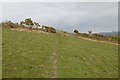
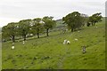
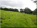
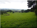
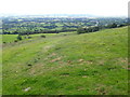
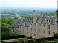
LL17 0AS is a small, tightly knit residential area in Wales, spanning 7.1 hectares and home to 1,655 people. Its compact size means it feels like a quiet, self-contained community, with a population density of 37 people per square kilometre. The area is characterised by its mix of older and newer housing stock, with a strong emphasis on homes rather than flats. Residents here are predominantly adults aged 30 to 64, reflecting a mature, stable demographic. The postcode’s proximity to natural landscapes, including parts of the Area of Outstanding Natural Beauty, offers a balance of rural tranquillity and accessible amenities. Daily life in LL17 0AS is shaped by its small-scale nature—local shops, a nearby railway station, and schools create a sense of convenience. While the area is not densely populated, its residents benefit from a low flood risk and proximity to protected woodland, which may appeal to those seeking a peaceful, low-impact lifestyle. For buyers, the limited size of LL17 0AS means properties are likely to be in close proximity to each other, with limited scope for expansion.
- Area Type
- Postcode
- Area Size
- 7.1 hectares
- Population
- 1655
- Population Density
- 37 people/km²
LL17 0AS is primarily an owner-occupied area, with 77% of properties owned by residents rather than rented. The housing stock consists almost entirely of houses, which is typical for rural and semi-rural postcodes in Wales. This suggests a market where properties are likely to be family homes, with limited availability of flats or apartments. The small size of the area—just 7.1 hectares—means the number of properties is limited, and buyers may need to look beyond LL17 0AS itself to find comparable options. The high home ownership rate indicates a stable market with little turnover, which can be attractive to buyers seeking long-term investment. However, the limited size of the area may also mean competition for properties is higher, and buyers should consider nearby postcodes for broader choices.
House Prices in LL17 0AS
Showing 3 properties
| Address | Type | Beds | Baths | Last Sale Price | Last Sale Date | |
|---|---|---|---|---|---|---|
| Chapel House, Road Adjacent To St Beuno From B 5429 To Maen Efa, Tremeirchion, St Asaph, LL17 0AS | undefined | - | - | - | - | |
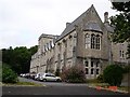
| Residential Accommodation, St Beunos College, B 5429 Pistyll To Nant Gwilym, Tremeirchion, St Asaph, LL17 0AS | hotel | - | - | - | - | |
| The Flat, St Beunos College, B 5429 Pistyll To Nant Gwilym, Tremeirchion, St Asaph, LL17 0AS | Flat | - | - | - | - |
Energy Efficiency in LL17 0AS
The lifestyle in LL17 0AS is shaped by its proximity to practical amenities, including five retail outlets such as Co-op St, Asda Singing Kettle S/Stn, and Spar. These shops provide access to essential goods, groceries, and daily necessities, reducing the need for long trips to larger centres. The nearby Prestatyn Railway Station adds convenience for those who rely on public transport, offering connections to broader regional networks. While the area’s small size means it lacks large-scale leisure facilities, the presence of protected woodland and the Area of Outstanding Natural Beauty nearby offers opportunities for outdoor activities. The combination of local shops, rail access, and natural surroundings creates a self-sufficient yet connected lifestyle, ideal for those seeking a balance between convenience and tranquillity.
Amenities
Schools
Residents of LL17 0AS have access to two nearby schools: Bodfari C.P. School and Ysgol Tremeirchion. Both are listed as "other" in terms of type, though specific details about their educational focus or Ofsted ratings are not provided. The presence of two schools suggests a range of options for families, though the exact nature of these institutions—whether primary, secondary, or specialist—remains unclear. For parents, the proximity of these schools to the area is a key consideration, as it reduces commuting time and supports a family-friendly environment. The mix of school types may indicate a variety of educational approaches, but without further data, it is difficult to assess their quality or performance.
| Rank | School | Type | Entry gender | Ages |
|---|
Explore more schools in this area
Go to Schools tabDemographics
The population of LL17 0AS is 1,655, with a median age of 47 and the majority of residents falling within the 30-64 age range. This suggests a community of middle-aged adults, many of whom may be established professionals or families. Home ownership is high at 77%, indicating a strong presence of long-term residents rather than transient renters. The area is predominantly composed of houses, not flats, which aligns with the demographic profile of older, family-oriented households. The predominant ethnic group is White, reflecting the broader trends in rural Wales. The population density of 37 people per square kilometre is low, contributing to a less congested, more spacious living environment. This combination of factors—stable age groups, high home ownership, and a focus on single-family homes—creates a community that prioritises privacy, stability, and a slower pace of life.
Household Size
Accommodation Type
Tenure
Ethnic Group
Religion
Household Composition
Age
Household Deprivation
NS-SEC
Explore more demographic insights in this area
Go to Demographics tabPlanning
Planning Constraints
- Flood RiskPremium
- Ramsar Wetland SitesPremium
- Area of Outstanding Natural BeautyPremium
- Protected Nature ReservePremium
- Protected WoodlandPremium
- Crime RiskPremium