Area Overview for LL16 3HQ
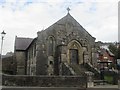
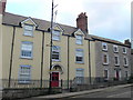
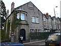
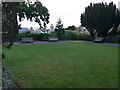
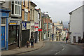
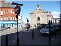
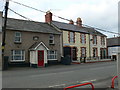
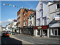
Photos of LL16 3HQ
Area Information
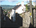
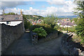
LL16 3HQ is a small, densely populated residential area in north Wales, with a compact footprint that fosters a close-knit community feel. The postcode covers just 1914 residents, spread across a high population density of 1792 people per square kilometre. This suggests a tightly clustered neighbourhood, likely centred around local amenities and services. As a Welsh postcode, it sits in a region known for its natural landscapes, though the area itself appears to be focused on residential living. Daily life here is shaped by proximity to retail and essential services, with a demographic skewed towards middle-aged and older residents. The area’s small size means that amenities and social hubs are likely within easy reach, though its limited scale may mean residents often travel beyond the immediate postcode for broader opportunities. For those seeking a quiet, established community with a strong sense of local identity, LL16 3HQ offers a distinct character, albeit with a need to balance its compact nature against the demands of modern living.
- Area Type
- Postcode
- Area Size
- Not available
- Population
- 1914
- Population Density
- 1792 people/km²
The property market in LL16 3HQ is dominated by owner-occupied homes, with 59% of properties held by their owners. This high rate of home ownership suggests a stable, long-term resident base, which can be an advantage for buyers seeking a reliable investment. The accommodation type is primarily houses, indicating a lack of high-density housing such as flats or apartments. This makes the area more suited to families or individuals preferring standalone properties. Given the small size of the postcode and its high population density, the housing stock is likely limited, meaning buyers should consider the immediate surrounding areas for additional options. The focus on houses may also mean that properties are more likely to be larger or older, which could influence both purchase prices and renovation potential. For those prioritising a quiet, established residential environment, the market here offers a distinct alternative to more urban or rapidly developing areas.
House Prices in LL16 3HQ
No properties found in this postcode.
Energy Efficiency in LL16 3HQ
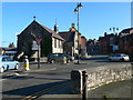
Residents of LL16 3HQ have access to a range of retail amenities within practical reach, including five notable stores such as Co-op Denbigh, Morrisons Denbigh, and Lidl Denbigh. These shops provide essential services, from groceries to household supplies, reducing the need for long commutes to larger centres. The presence of multiple retail options suggests a well-served community, though the data does not specify other amenities like parks, dining venues, or leisure facilities. The area’s small size likely means that daily errands and social activities are concentrated in nearby hubs, which can enhance convenience but may also limit the diversity of experiences available. For those prioritising proximity to shops and a functional retail environment, LL16 3HQ offers a practical setup, though further research would be needed to assess the full range of lifestyle options in the surrounding region.
Amenities
Schools
The only school explicitly listed near LL16 3HQ is Howell’s Preparatory School, which is categorised as an 'other' type. No Ofsted rating or specific details about its curriculum or age range are provided in the data. Families relying on this school would need to consider its proximity and whether it meets their child’s educational needs. The absence of other schools in the immediate area suggests that parents may need to look beyond LL16 3HQ for secondary education or additional options. This could be a consideration for families prioritising a range of school types, such as state primary schools, secondary institutions, or specialist provision. The data does not indicate whether the existing school is sufficient for local demand, but the lack of alternatives may influence decisions about where to live in the area.
| Rank | School | Type | Entry gender | Ages |
|---|
Explore more schools in this area
Go to Schools tabDemographics
The population of LL16 3HQ has a median age of 47, with the most common age range being adults aged 30 to 64. This suggests a mature community, likely composed of long-term residents, families, and professionals. Home ownership in the area stands at 59%, indicating a stable housing market where nearly six in ten properties are owner-occupied. The predominant accommodation type is houses, which aligns with the area’s residential character and may reflect a preference for private, family-oriented living spaces. The predominant ethnic group is White, which is consistent with broader demographic trends in Wales. While no specific data on deprivation or diversity is provided, the age profile and home ownership rate imply a community that is relatively settled, with limited turnover in housing. This stability may contribute to a cohesive neighbourhood dynamic, though the area’s small size means its demographic makeup is unlikely to shift significantly without external influence.
Household Size
Accommodation Type
Tenure
Ethnic Group
Religion
Household Composition
Age
Household Deprivation
NS-SEC
Explore more demographic insights in this area
Go to Demographics tabPlanning
Planning Constraints
- Flood RiskPremium
- Ramsar Wetland SitesPremium
- Area of Outstanding Natural BeautyPremium
- Protected Nature ReservePremium
- Protected WoodlandPremium
- Crime RiskPremium