Area Overview for Rhos-on-Sea Community
Photos of Rhos-on-Sea Community


Area Information
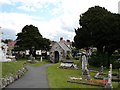
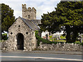
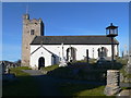
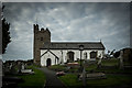
Living in Rhos-on-Sea Community offers a distinct experience compared to larger urban centres. This civil parish covers an area of 4.1 km² and serves as a seaside resort adjacent to Colwyn Bay within Conwy County Borough, Wales. The location sits on land that slopes gently northwards towards the coast, providing a defined geographical identity. With a population of 1,409, the community maintains a small village character despite its development from scattered farms in the 19th century. Historical records show that the area links to the ancient Welsh kingdom of Rhos and features a Romano-British hill fort on Bryn Euryn alongside a 9th-century monastery site. You will find housing that has spread over centuries, including the distinctive Elwy Road estate built between 1952 and 1961. For those considering homes in Rhos-on-Sea Community, the environment reflects a blend of heritage and coastal living. It is situated between Llandudno and Colwyn Bay, creating a routine travel network for many residents. The area currently stands as a parish where daily life balances seaside leisure with a history dating back to late Roman Britain. Anyone looking for a property in this specific civil parish finds a setting defined by its proximity to the sea and its deep historical roots.
- Area Type
- Parish
- Area Size
- 4.1 km²
- Population
- 1409
- Population Density
- 343 people/km²
Demographics
The demographic profile of Rhos-on-Sea reveals a mature community with a median age of 70. This figure places the area significantly older than the national average for the United Kingdom. The most common age bracket encompasses the total population, suggesting a uniform shift towards older residents rather than a traditional family mix. While specific data on household composition and accommodation types lists totals without breaking them down further, the high age median indicates that families with young children are less likely to be the primary residents. A notable 64% of the population owns their homes outright, signalling a long-standing settlement pattern where pensioners have remained in their properties. This high ownership rate contrasts sharply with regions dominated by private rental markets. The community does not report specific ethnic group or religious preferences in the available data, meaning diversity patterns are not explicitly quantified here. Residents accept this quiet, older demographic composition as the defining feature of their neighbourhood. If you are evaluating schools near Rhos-on-Sea Community, the local age profile suggests a demand for retirement-focused amenities rather than primary education facilities. Living in this area means sharing space with peers who have lived there for decades.
Household Size
Accommodation Type
Tenure
Ethnic Group
Religion
Household Composition
Age
Household Deprivation
NS-SEC
Explore more demographic insights in this area
Go to Demographics tabPlanning
Planning Constraints
- Flood RiskPremium
- Ramsar Wetland SitesPremium
- Area of Outstanding Natural BeautyPremium
- Protected Nature ReservePremium
- Protected WoodlandPremium
- Crime RiskPremium