Area Overview for LL32 8FZ
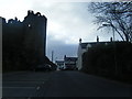
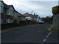
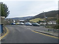
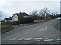
Photos of LL32 8FZ
Area Information
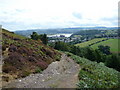
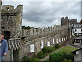
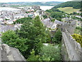
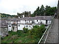
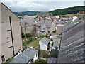
Living in LL32 8FZ means inhabiting a small, densely populated residential cluster in north Wales. The area covers just 1.7 hectares, yet it accommodates 1,409 residents, translating to a population density of 82,677 people per square kilometre. This compactness suggests a tightly knit community, with homes likely arranged closely together. The area’s character is shaped by its proximity to amenities such as rail stations, retail outlets, and schools, which are all within practical reach. While the data does not specify historical or cultural context, the presence of multiple schools and transport links hints at a focus on accessibility. LL32 8FZ is not a sprawling suburb but a concentrated neighbourhood, ideal for those prioritising convenience over expansive living spaces. Its small size may limit housing diversity, but it ensures that residents are never far from essential services. The area’s appeal lies in its balance between residential tranquillity and proximity to infrastructure, making it suitable for commuters or those seeking a compact, well-connected home.
- Area Type
- Postcode
- Area Size
- 1.7 hectares
- Population
- 1409
- Population Density
- 1585 people/km²
LL32 8FZ is predominantly an owner-occupied area, with 70% of homes owned by residents rather than rented. The accommodation type is exclusively houses, which is uncommon in densely populated areas but suggests a focus on family-friendly or semi-detached housing. Given the area’s small size and high population density, the housing stock is limited, meaning the market is likely competitive for buyers. The concentration of houses may indicate a preference for private, standalone properties over flats or apartments. For prospective buyers, this means the area is not ideal for those seeking rental properties or a wider range of housing types. The compact nature of LL32 8FZ also implies that any new developments would face spatial constraints, potentially limiting future growth.
House Prices in LL32 8FZ
No properties found in this postcode.
Energy Efficiency in LL32 8FZ
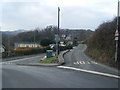
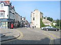
Residents of LL32 8FZ benefit from a range of amenities within easy reach. The area’s retail options include Spar, Tesco Llandudno, and Lidl, offering grocery and convenience shopping. Nearby rail stations and metro stops, such as Victoria and Summit, provide access to public transport, reducing the need for private cars. While the data does not mention parks or leisure facilities, the compact nature of the area suggests that residents may rely on nearby towns for recreational spaces. The presence of multiple schools and transport links indicates a lifestyle focused on accessibility and practicality. Daily life here is likely characterised by a balance between residential comfort and the ease of accessing services, making it suitable for those who prioritise convenience over expansive living spaces.
Amenities
Schools
Residents of LL32 8FZ have access to three schools within practical reach: Ysgol Trefriw, Ysgol Porth y Felin, and Conwy Secondary Pupil Referral Unit. All are categorised as “other” in the data, which does not specify their educational levels or Ofsted ratings. The presence of a secondary pupil referral unit suggests the area may cater to students with additional needs, while the other two schools could serve primary or secondary roles. Families seeking a variety of educational options may benefit from this mix, though the absence of detailed ratings means potential buyers must investigate further. The proximity of these schools to homes in LL32 8FZ underscores the area’s focus on accessibility for families.
| Rank | School | Type | Entry gender | Ages |
|---|
Explore more schools in this area
Go to Schools tabDemographics
The population of LL32 8FZ is predominantly adults aged 30–64, with a median age of 47. This suggests a community of established professionals, families, or retirees, rather than a younger demographic. Home ownership is high at 70%, indicating a stable, long-term resident base. The accommodation type is primarily houses, which aligns with the area’s residential character. The predominant ethnic group is White, though no data on other ethnicities is provided. The high population density, combined with the prevalence of owner-occupied homes, points to a community where property is viewed as a long-term investment. With 1,409 residents in such a small area, social interactions are likely frequent, fostering a sense of familiarity. However, the lack of diversity data means the full picture of the community’s composition remains incomplete.
Household Size
Accommodation Type
Tenure
Ethnic Group
Religion
Household Composition
Age
Household Deprivation
NS-SEC
Explore more demographic insights in this area
Go to Demographics tabPlanning
Planning Constraints
- Flood RiskPremium
- Ramsar Wetland SitesPremium
- Area of Outstanding Natural BeautyPremium
- Protected Nature ReservePremium
- Protected WoodlandPremium
- Crime RiskPremium