Area Overview for LL30 2BS
Photos of LL30 2BS
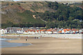

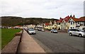
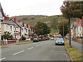
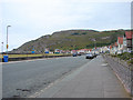
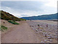

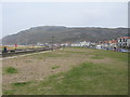
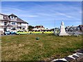
100 photos from this area
Area Information
Key information about the LL30 2BS including its size, population, and administrative classification.
- Area Type
- Postcode
- Area Size
- 6008 m²
- Population
- 1491
- Population Density
- 365 people/km²
House Prices in LL30 2BS
19
Properties
£187,250
Average Sold Price
£68,750
Lowest Price
£310,000
Highest Price
Showing 19 properties
| Address | Type | Beds | Baths | Last Sale Price | Last Sale Date | |
|---|---|---|---|---|---|---|
| 14 Morfa Road, Llandudno, LL30 2BS | Bungalow | 3 | 2 | £310,000 | Apr 2024 | |
| 8 Morfa Road, Llandudno, LL30 2BS | Semi-detached | 3 | 1 | £185,000 | Apr 2021 | |
| 7 Morfa Road, Llandudno, LL30 2BS | Semi-detached | 4 | 1 | £195,000 | Mar 2021 | |
| 11 Morfa Road, Llandudno, LL30 2BS | Detached | 4 | 2 | £180,000 | Jul 2018 | |
| 10 Morfa Road, Llandudno, LL30 2BS | Retail | 3 | 2 | £177,500 | Apr 2017 | |
| 16 Morfa Road, Llandudno, LL30 2BS | Semi-detached | - | - | £232,500 | Nov 2007 | |
| 15 Morfa Road, Llandudno, LL30 2BS | house | - | - | £240,000 | Jul 2007 | |
| 12 Morfa Road, Llandudno, LL30 2BS | Semi-detached | 3 | 2 | £96,500 | Apr 2001 | |
| 3 Morfa Road, Llandudno, LL30 2BS | Semi-detached | - | - | £68,750 | Oct 1999 | |
| Flat 3, 2 Morfa Road, Llandudno, LL30 2BS | Flat | - | - | - | - |
Page 1 of 2
Energy Efficiency in LL30 2BS
Amenities
Schools
| Rank | School | Type | Entry gender | Ages |
|---|
Explore more schools in this area
Go to Schools tabDemographics
Household Size
One person
most common
Accommodation Type
Houses
most common
Tenure
70
majority
Ethnic Group
White
most common
Religion
N/A
most common
Household Composition
N/A
most common
Age
47
median
Elderly (65+ years)
most common
Household Deprivation
N/A
with no deprivation
NS-SEC
31
in Lower managerial occupations
Explore more demographic insights in this area
Go to Demographics tabPlanning
Planning Constraints
- Flood RiskPremium
- Ramsar Wetland SitesPremium
- Area of Outstanding Natural BeautyPremium
- Protected Nature ReservePremium
- Protected WoodlandPremium
- Crime RiskPremium