Area Overview for LL29 8LD
Photos of LL29 8LD


Area Information
Living in LL29 8LD means being part of a small, tightly knit residential cluster in Wales with a population of just over 2,000 people. This area is defined by its compact nature, where daily life is shaped by proximity to local amenities and a quiet, community-focused atmosphere. The median age of 47 suggests a mature population, with most residents falling into the 30-64 age range. While the area is small, it offers practical access to nearby rail and metro stations, making it easier to commute to larger towns or cities. The housing stock here is predominantly flats, reflecting a mix of owner-occupied and rental properties. For those seeking a low-maintenance lifestyle with easy access to essential services, LL29 8LD provides a straightforward, no-frills environment. However, its small size means the area is best suited to those prioritising convenience over expansive living spaces. The absence of major planning constraints or environmental risks adds to its appeal for buyers looking for a stable, straightforward place to settle.
- Area Type
- Postcode
- Area Size
- Not available
- Population
- 2077
- Population Density
- 3923 people/km²
The property market in LL29 8LD is characterised by a high proportion of flats, with no data suggesting the presence of larger homes or detached properties. At 42% home ownership, the area leans more towards a rental market than owner-occupied living, which may influence the types of properties available. Flats in this area are likely to be smaller, suited to individuals or couples rather than growing families. For buyers, this means limited options for larger homes, though the compact nature of the area could make flats a practical choice for those prioritising ease of maintenance and proximity to amenities. The small population also means the housing stock is unlikely to expand significantly, making any available properties potentially competitive. Prospective buyers should consider whether a flat in this area aligns with their long-term needs, particularly if they require more space or plan to move to a larger home in the future.
House Prices in LL29 8LD
No properties found in this postcode.
Energy Efficiency in LL29 8LD
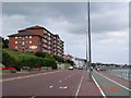
The lifestyle in LL29 8LD is shaped by its proximity to essential amenities, including retail outlets such as Morrisons Llandrillo-yn, Heron Colwyn, and Lidl Llandrillo-yn. These shops provide access to groceries and everyday essentials without requiring long trips. The area’s rail and metro stations, including Colwyn Bay and Victoria, enhance connectivity, enabling residents to reach larger towns or cities for leisure, dining, or specialist services. While there is no data on parks or recreational facilities within the immediate area, the presence of nearby stations suggests opportunities for cultural or social activities beyond the local cluster. The convenience of nearby shopping and transport options contributes to a practical, low-effort lifestyle, though those seeking extensive leisure facilities may need to look further afield.
Amenities
Schools
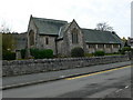
The nearest school to LL29 8LD is St Joseph’s R.C. Primary School, which serves the local community. As a primary school, it caters to younger children, though no data is available on its Ofsted rating or specific curriculum. The absence of secondary schools or other educational institutions in the immediate vicinity means families may need to look further afield for comprehensive schooling. This could be a consideration for parents seeking a full range of educational options for their children. However, the presence of a primary school does provide a local resource for younger families, reducing the need for long commutes. The single school listed suggests a limited choice for education, which may influence decisions about where to live within the area.
| Rank | School | Type | Entry gender | Ages |
|---|
Explore more schools in this area
Go to Schools tabDemographics
The community in LL29 8LD is predominantly composed of adults aged 30-64, with a median age of 47. This suggests a population that is largely settled, with fewer young families or retirees compared to other areas. Home ownership stands at 42%, indicating that nearly half of residents rent their homes, while the remaining 58% are likely to be private renters or live in other tenure types. The accommodation type is exclusively flats, which aligns with the area’s compact nature and suggests a focus on smaller, manageable living spaces. The predominant ethnic group is White, with no data provided on other demographics. The low population size and mature age profile imply a community with established routines and limited turnover. While this stability can be reassuring, it also means the area lacks the diversity of age groups or cultural backgrounds found in larger towns.
Household Size
Accommodation Type
Tenure
Ethnic Group
Religion
Household Composition
Age
Household Deprivation
NS-SEC
Explore more demographic insights in this area
Go to Demographics tabPlanning
Planning Constraints
- Flood RiskPremium
- Ramsar Wetland SitesPremium
- Area of Outstanding Natural BeautyPremium
- Protected Nature ReservePremium
- Protected WoodlandPremium
- Crime RiskPremium