Area Overview for LL24 9AA
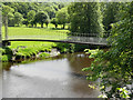
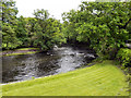
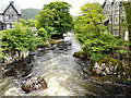
Photos of LL24 9AA

Area Information
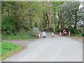
Living in LL24 9AA means being part of a small, low-density residential cluster in Wales, where the population of 1,148 people spreads across a landscape with just 7 residents per square kilometre. This area feels distinctly rural, with a quiet, unhurried pace of life. The community is predominantly composed of adults aged 30–64, reflecting a mature demographic that leans towards home ownership, with 74% of properties owned outright. Daily life here is shaped by proximity to natural surroundings and a reliance on local amenities. While the area lacks major urban hubs, its small size means residents can access nearby towns and services without long commutes. The absence of planning constraints like protected woodlands or AONB designations suggests a flexible environment for development, though the sparse population density means community interactions are likely limited to immediate neighbours. For those seeking a tranquil, low-key lifestyle, LL24 9AA offers a snapshot of rural Welsh living, with a focus on self-sufficiency and local connectivity.
- Area Type
- Postcode
- Area Size
- Not available
- Population
- 1148
- Population Density
- 7 people/km²
The property market in LL24 9AA is characterised by a high rate of home ownership (74%) and a predominance of houses over flats or other accommodation types. This suggests a market that is largely owner-occupied, with limited rental activity. The low population density of 7 people per square kilometre means properties are likely to be larger and more spread out, catering to families or individuals seeking space rather than urban convenience. For buyers, this implies a focus on long-term investment, as the area’s small size and rural nature may limit speculative development. The lack of planning constraints, such as protected woodlands or AONB designations, could make it easier to modify or expand properties, though the sparse population might mean limited demand for new builds. Given the area’s size and demographics, property values are likely to be influenced more by location and land availability than by proximity to major cities. Buyers should consider the practicality of living in a low-density area with limited local amenities, where daily needs are met through nearby towns rather than within the postcode itself.
House Prices in LL24 9AA
No properties found in this postcode.
Energy Efficiency in LL24 9AA
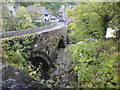
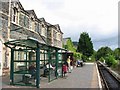
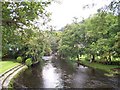
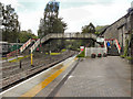
The lifestyle in LL24 9AA is shaped by its proximity to specific retail and transport hubs. Residents have access to four retail points, including Spar - Betws-Y and Co-op Llanrwst, which provide essentials like groceries and daily necessities. These stores are likely to serve a broader local area, given the postcode’s small population. The rail network, with stations at Betws, Pont, and Llanrwst, offers connections to nearby towns, enabling access to more extensive shopping, dining, and leisure opportunities. While the area itself lacks detailed information on parks or recreational facilities, the absence of planning constraints like protected woodlands suggests open spaces may be available for informal activities. The character of daily life here is defined by simplicity: convenience comes from nearby towns, while the rural setting offers a quieter, less congested environment. For those valuing local amenities, the mix of retail and rail access provides a baseline for practical living, though the area’s small size means community life is likely to revolve around immediate neighbours and local traditions.
Amenities
Schools
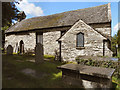
Residents of LL24 9AA have access to two schools within practical reach: Ysgol Betws-y-Coed and Ysgol Dolwyddelan, both categorised as ‘other’ in the data. While specific Ofsted ratings are not provided, the presence of two schools suggests a basic educational infrastructure for the area’s small population. The mix of school types may offer families a range of options, though the limited number of institutions could mean longer commutes for students needing specialist provision. Given the area’s low population density, these schools likely serve a broader local catchment beyond LL24 9AA itself. For families prioritising proximity to education, the availability of these schools is a key consideration, though the lack of detailed performance data means potential buyers must rely on local reputation or further research. The absence of primary or secondary school ratings in the data underscores the need for additional due diligence when assessing the quality of education in the area.
| Rank | School | Type | Entry gender | Ages |
|---|
Explore more schools in this area
Go to Schools tabDemographics
The demographic profile of LL24 9AA is defined by its median age of 47, with the majority of residents falling within the 30–64 age range. This suggests a community of established professionals and families, rather than students or younger workers. Home ownership is high, at 74%, indicating a stable, long-term resident base. The accommodation type is predominantly houses, which aligns with the area’s low population density and rural character. The predominant ethnic group is White, reflecting the broader demographic trends in Wales. While no specific data on deprivation or diversity is provided, the age profile and home ownership rate imply a community that prioritises stability and long-term residency over transient living. For prospective buyers, this suggests a market where properties are likely to be occupied by owners rather than renters, with fewer turnover pressures. The absence of detailed diversity statistics means the area’s social fabric remains largely unexplored in the data, but the figures provided paint a picture of a cohesive, middle-aged population.
Household Size
Accommodation Type
Tenure
Ethnic Group
Religion
Household Composition
Age
Household Deprivation
NS-SEC
Explore more demographic insights in this area
Go to Demographics tabPlanning
Planning Constraints
- Flood RiskPremium
- Ramsar Wetland SitesPremium
- Area of Outstanding Natural BeautyPremium
- Protected Nature ReservePremium
- Protected WoodlandPremium
- Crime RiskPremium