Area Overview for LL22 9AE
Photos of LL22 9AE


Area Information
Living in LL22 9AE means being part of a small, tightly knit residential cluster in north Wales. With a population of 1,348 spread over a compact area, the community feels close-knit, with a population density of 731 people per square kilometre. This is a place where daily life is shaped by proximity to local amenities and a relatively stable demographic. The area is home to a mature population, with a median age of 47 and the majority of residents falling within the 30–64 age range. This suggests a community with established careers and families, reflected in the high home ownership rate of 78%. The housing stock is predominantly houses, which contributes to a sense of permanence and privacy. While the area lacks large-scale infrastructure, its small size means residents are never far from essential services. The postcode’s location in Wales offers a distinct cultural and geographical identity, though it remains accessible to nearby towns via rail and road. For those seeking a quiet, stable environment with a focus on local living, LL22 9AE provides a straightforward, no-frills lifestyle.
- Area Type
- Postcode
- Area Size
- Not available
- Population
- 1348
- Population Density
- 731 people/km²
The property market in LL22 9AE is characterised by a high rate of home ownership, with 78% of residents living in their own homes. This suggests a market that is largely owner-occupied rather than rental-focused, which can indicate stability and long-term investment in the area. The predominant accommodation type is houses, which is typical for smaller, rural or semi-rural postcodes. Given the area’s compact size and limited development, the housing stock is likely to be older, with fewer high-density or modern developments. For buyers, this means a focus on existing homes rather than new builds, with properties likely to be family-sized and designed for long-term living. The small scale of the area means that the property market is not extensive, and opportunities may be limited to specific locations within the postcode. However, the high home ownership rate suggests that properties here may hold value, particularly for those seeking a quiet, low-maintenance lifestyle. Prospective buyers should consider the limited number of available homes and the potential for slower market turnover.
House Prices in LL22 9AE
No properties found in this postcode.
Energy Efficiency in LL22 9AE
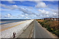
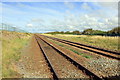
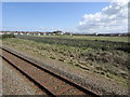
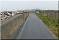
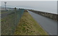
Residents of LL22 9AE have access to a modest but practical range of amenities within reach. The area includes two railway stations—Abergele & Pensarn and Rhyl—offering regular services to nearby towns and cities. For retail, there are five notable venues, including Co-op Pensarn and Spar, providing essentials like groceries and daily supplies. These shops cater to local needs, ensuring residents can manage routine purchases without long journeys. While the data does not mention parks or leisure facilities, the proximity to rail services suggests that recreational opportunities may be available in nearby towns. The small scale of the area means that amenities are concentrated, which can be both convenient and limiting depending on individual preferences. For those prioritising accessibility to shops and transport, LL22 9AE offers a straightforward lifestyle with minimal need for long commutes. The character of the area is defined by its practicality, with daily life revolving around local services and the surrounding regional networks.
Amenities
Schools
| Rank | School | Type | Entry gender | Ages |
|---|
Explore more schools in this area
Go to Schools tabDemographics
The community in LL22 9AE is predominantly composed of adults aged 30–64, with a median age of 47. This suggests a population that is largely in their prime working years, with many likely to be settled in long-term careers or raising families. The high home ownership rate of 78% indicates a stable housing market, with most residents living in their own homes rather than renting. Accommodation is primarily houses, which aligns with the area’s small, residential character. The predominant ethnic group is White, though no specific data on diversity or deprivation is provided. The population density of 731 people per square kilometre means the area is neither sparse nor overcrowded, offering a balance between privacy and community interaction. This demographic profile points to a place where residents value stability, with fewer transient populations and a focus on long-term residence. The absence of detailed diversity statistics means the community’s full composition remains partially opaque, but the available data suggests a homogeneous, middle-aged population with strong ties to their homes.
Household Size
Accommodation Type
Tenure
Ethnic Group
Religion
Household Composition
Age
Household Deprivation
NS-SEC
Explore more demographic insights in this area
Go to Demographics tabPlanning
Planning Constraints
- Flood RiskPremium
- Ramsar Wetland SitesPremium
- Area of Outstanding Natural BeautyPremium
- Protected Nature ReservePremium
- Protected WoodlandPremium
- Crime RiskPremium