Area Overview for LL22 8DJ
Photos of LL22 8DJ
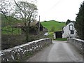
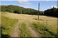
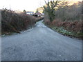
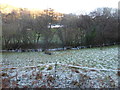
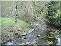

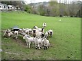
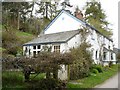
8 photos from this area
Area Information
Key information about the LL22 8DJ including its size, population, and administrative classification.
- Area Type
- Postcode
- Area Size
- 63.7 hectares
- Population
- 1819
- Population Density
- 14 people/km²
House Prices in LL22 8DJ
13
Properties
£226,716
Average Sold Price
£107,010
Lowest Price
£345,000
Highest Price
Showing 13 properties
| Address | Type | Beds | Baths | Last Sale Price | Last Sale Date | |
|---|---|---|---|---|---|---|
| Hen Felin, Felin Pandy, Llanfairtalhaiarn, LL22 8DJ | Detached | 2 | 2 | £345,000 | Oct 2024 | |
| Bryn Onnen, Y Fron Fawr, Llannefydd, LL22 8DJ | Bungalow | 1 | 1 | £150,000 | Jan 2017 | |
| Pen Yr Allt, Y Fron Fawr, Llannefydd, LL22 8DJ | Cottage | 3 | - | £310,000 | Jan 2014 | |
| Bryn Y Gwynt, Y Fron Fawr, Llannefydd, LL22 8DJ | Detached | 4 | - | £342,000 | Aug 2013 | |
| Bont Bach, Ty Canol Road, Llanfairtalhaiarn, LL22 8DJ | Detached | - | - | £215,000 | Apr 2004 | |
| Glyn, Y Fron Fawr, Llannefydd, LL22 8DJ | Detached | - | - | £118,000 | Mar 1998 | |
| Fron Fawr Cottage, Ty Canol Road, Llanfairtalhaiarn, LL22 8DJ | Detached | - | - | £107,010 | Aug 1995 | |
| Fron Fawr, Ty Canol Road, Llanfairtalhaiarn, LL22 8DJ | Detached | 3 | - | - | - | |
| Pont Yr Aled Bach, Pont Yr Aled, Llannefydd, LL22 8DJ | undefined | - | - | - | - | |
| Pen Y Waen, Y Fron Fawr, Llannefydd, LL22 8DJ | Detached | - | - | - | - |
Page 1 of 2
Energy Efficiency in LL22 8DJ
Amenities
Schools
| Rank | School | Type | Entry gender | Ages |
|---|
Explore more schools in this area
Go to Schools tabDemographics
Household Size
Two person
most common
Accommodation Type
Houses
most common
Tenure
77
majority
Ethnic Group
White
most common
Religion
N/A
most common
Household Composition
N/A
most common
Age
47
median
Adults (30-64 years)
most common
Household Deprivation
N/A
with no deprivation
NS-SEC
33
in Lower managerial occupations
Explore more demographic insights in this area
Go to Demographics tabPlanning
Planning Constraints
- Flood RiskPremium
- Ramsar Wetland SitesPremium
- Area of Outstanding Natural BeautyPremium
- Protected Nature ReservePremium
- Protected WoodlandPremium
- Crime RiskPremium