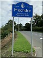
Area Overview for Mochdre Community
Photos of Mochdre Community


Area Information
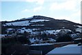
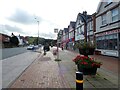
Living in Mochdre Community offers a distinctly rural experience within a civil parish in Wales. This compact area spans just 2.8 km², creating an intimate setting where local life moves at a deliberate pace. The community defines itself through a strong sense of location rather than the high-density urban sprawl found elsewhere in Britain. You will find that daily life here revolves around proximity and established neighbourhood patterns rather than major commercial hubs. The small scale ensures that residents are closely connected to their immediate surroundings without the noise and congestion of larger towns. The parish character remains intact, providing a stable environment for those seeking quiet residences away from the commuter rush. There are no city centres within immediate view, meaning your weekends are likely reserved for local parks, country walks, or community events rather than shopping trips to Cardiff or neighbouring Loudon. This simplicity is the core appeal for anyone considering Mochdre Community. The area functions as a self-contained unit where the layout supports a slower lifestyle. Whether you arrive by car or on foot, the distance between homes is manageable. You do not face the gridlock associated with larger Welsh valleys. The geography supports a life focused on home and local interactions. For buyers arriving in Mochdre Community, the challenge involves access to wider commercial services, which require travel. However, the trade-off is a pervasive sense of calm and security that larger parishes struggle to maintain. The area size limits the chance of finding hidden industrial pockets, ensuring a consistent residential atmosphere. You should expect a peaceful morning routine without the roar of heavy traffic overhead. This remains a pure residential settlement where the primary function of the land is habitation. The community succeeds by keeping its boundaries clear and its purpose specific.
- Area Type
- Parish
- Area Size
- 2.8 km²
- Population
- Not available
- Population Density
- Not available
Demographics
The community profile of Mochdre Community reflects a settled population with established roots. The median age sits at 70 years, indicating that a significant portion of residents are seniors. This demographic shift suggests an area dominated by older couples living independently or downsizing from previous properties. You will encounter few young families raising children in large houses, as the population structure does not support that demographic density. The most common age range spans the entire population, reinforcing the notion that this is a mature community rather than a student hub or family enclave. Home ownership stands at 64 percent, a high figure that typically signals long-term stability and financial security among residents. Most households have purchased their properties outright or have ties spanning decades, reducing the turnover rate seen in bustling city stops. This ownership model fosters a cohesive community where neighbours know each other well. The accommodation types available align with this ownership pattern, favouring managed housing estates over high-rise flats or social rentals. Ethnic diversity remains a central fact, though specific data on the breakdown of groups is not detailed in the current records. Religious affiliation is another area of demographic interest, yet the precise breakdown of faith groups is not currently quantified in the available statistics. This lack of specific religious census data does not diminish the community's social fabric, which relies more on shared geography than formal congregation lists. Deprivation levels are not explicitly detailed in the provided figures, suggesting the area does not suffer from the acute poverty markers found in wider Valleys regions. Instead, the focus remains on stability. If you are considering homes in Mochdre Community, you will find a market driven by long-term residents rather than transient workers. The household composition reflects this permanence, with extended families or retired couples maintaining their residences for generations.
Household Size
Accommodation Type
Tenure
Ethnic Group
Religion
Household Composition
Age
Household Deprivation
NS-SEC
Explore more demographic insights in this area
Go to Demographics tabPlanning
Planning Constraints
- Flood RiskPremium
- Ramsar Wetland SitesPremium
- Area of Outstanding Natural BeautyPremium
- Protected Nature ReservePremium
- Protected WoodlandPremium
- Crime RiskPremium