Area Overview for Caerhun Community
Photos of Caerhun Community


Area Information
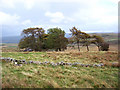
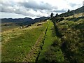
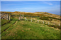
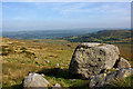
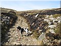
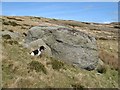
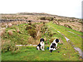
Caerhun Community is a civil parish in Wales covering an extensive area of 57.3 square kilometres. Living in Caerhun Community means engaging with a landscape defined by significant rural space rather than dense urban sprawl. The parish offers a quiet, spacious environment that stands in contrast to the tighter quarters of nearby town centres. You will find yourself traversing a large territory where natural features dominate the daily scenery. This distinction shapes the character of life here. People who choose homes in Caerhun Community often prioritise open space and tranquility over immediate access to city amenities. The vastness of the area influences how you experience your surroundings, with fewer neighbours visible at any given time. This setting suits those seeking a slower pace and a connection to the wider Welsh countryside. The parish provides a backdrop of openness that defines the rhythm of daily activities. Prospective buyers should recognise the scale of this location. The sheer size of Caerhun Community influences everything from travel times to the availability of local services. You are entering a setting where every household benefits from a high degree of privacy. The environment here rewards those who value distance from the noise of major roads and urban congestion. Understanding the layout of this 57.3 km² area is essential for anyone considering a move.
- Area Type
- Parish
- Area Size
- 57.3 km²
- Population
- Not available
- Population Density
- Not available
Demographics
The community profile of Caerhun Community reflects an older demographic pattern. You will find that the median age across the parish is 70 years old. This figure indicates that the majority of residents are senior citizens. Age groups skew heavily toward the older end of the scale, meaning you are unlikely to encounter many young families during your walks around the neighbourhood. Home ownership drives the social structure of the area more than renting does. With 79% of households owning their property, a significant majority of residents have a long-term stake in Caerhun Community. This high level of ownership often suggests stable residency and a community invested in maintaining the local environment. The remaining 21% live in rented accommodation, which may be available to those seeking short-term stays or local employment opportunities. Accommodation types and household compositions in Caerhun Community cater primarily to an older population. The data confirms that this is not a family-heavy zone but rather a retirement or senior-centric locale. You should expect neighbours who have lived in the area for decades. The lack of young households means a quieter day-to-day atmosphere. This demographic reality determines the pace of local life and the needs of existing services. Anyone buying homes in Caerhun Community is stepping into an established community of older residents.
Household Size
Accommodation Type
Tenure
Ethnic Group
Religion
Household Composition
Age
Household Deprivation
NS-SEC
Explore more demographic insights in this area
Go to Demographics tabPlanning
Planning Constraints
- Flood RiskPremium
- Ramsar Wetland SitesPremium
- Area of Outstanding Natural BeautyPremium
- Protected Nature ReservePremium
- Protected WoodlandPremium
- Crime RiskPremium