Area Overview for SY23 5HX
Photos of SY23 5HX
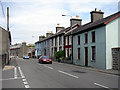

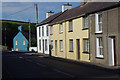
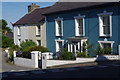
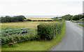
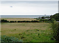
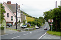

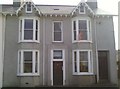
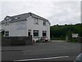

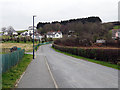
20 photos from this area
Area Information
Key information about the SY23 5HX including its size, population, and administrative classification.
- Area Type
- Postcode
- Area Size
- 19.7 hectares
- Population
- 1155
- Population Density
- 91 people/km²
House Prices in SY23 5HX
17
Properties
£144,417
Average Sold Price
£42,000
Lowest Price
£245,000
Highest Price
Showing 17 properties
| Address | Type | Beds | Baths | Last Sale Price | Last Sale Date | |
|---|---|---|---|---|---|---|
| Bryntawel, U 1409 From Heol Non To Cledan Bridge, Llanon, SY23 5HX | Cottage | 3 | 2 | £155,000 | Jul 2020 | |
| Sunny Hill, U 1408 From The Junction Of The C 1116 To The Well, Llanon, SY23 5HX | Detached | - | - | £245,000 | Jul 2006 | |
| Ty'n Cwm, U 1409 From Heol Non To Cledan Bridge, Llanon, SY23 5HX | Cottage | 3 | 2 | £127,000 | Jul 2005 | |
| Sunny Mount, U 1409 From Heol Non To Cledan Bridge, Llanon, SY23 5HX | house | 4 | 3 | £190,000 | Jul 2004 | |
| Y Felin, U 1409 From Heol Non To Cledan Bridge, Llanon, SY23 5HX | Detached | - | - | £107,500 | Apr 1997 | |
| Brackenbury, U 1408 From The Junction Of The C 1116 To The Well, Llanon, SY23 5HX | Detached | - | - | £42,000 | Jun 1996 | |
| Ty Coed, U 1409 From Heol Non To Cledan Bridge, Llanon, SY23 5HX | Bungalow | 2 | 1 | - | - | |
| Mount, U 1409 From Heol Non To Cledan Bridge, Llanon, SY23 5HX | house | 3 | 2 | - | - | |
| Mount Cottage, U 1409 From Heol Non To Cledan Bridge, Llanon, SY23 5HX | Detached | - | - | - | - | |
| Plot Adjacent Sunny Hill, U 1408 From The Junction Of The C 1116 To The Well, Llanon, SY23 5HX | Semi-detached | - | - | - | - |
Page 1 of 2
Energy Efficiency in SY23 5HX
Amenities
Schools
| Rank | School | Type | Entry gender | Ages |
|---|
Explore more schools in this area
Go to Schools tabDemographics
Household Size
Two person
most common
Accommodation Type
Houses
most common
Tenure
72
majority
Ethnic Group
White
most common
Religion
N/A
most common
Household Composition
N/A
most common
Age
47
median
Adults (30-64 years)
most common
Household Deprivation
N/A
with no deprivation
NS-SEC
32
in Lower managerial occupations
Explore more demographic insights in this area
Go to Demographics tabPlanning
Planning Constraints
- Flood RiskPremium
- Ramsar Wetland SitesPremium
- Area of Outstanding Natural BeautyPremium
- Protected Nature ReservePremium
- Protected WoodlandPremium
- Crime RiskPremium