Area Overview for SA44 5YJ
Photos of SA44 5YJ


Area Information
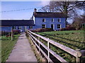
Living in SA44 5YJ means residing in a tightly defined postcode area that functions as a small residential cluster. This specific location sits within Wales and serves approximately 1,764 people. The density here is low, standing at just 59 people per square kilometre. This figure suggests a quiet, spread-out living environment rather than a dense urban setting. The area is characterised by its residential exclusivity, offering a distinct separation from busier commercial centres. You find a community where space is available and the pace of life remains manageable. The structure of this postcode is simple, focusing entirely on housing needs for a local population. Prospective homebuyers will note that this is not a sprawling district but a concentrated neighbourhood. The boundaries are clear, defining a specific zone for local services and governance. You enter a space designed primarily for dwelling, with limited industrial or commercial intrusion recorded in its official profile. The sense of place is defined by its size and the specific clusters of homes that comprise the 1,764 residents. Whether you are looking for a retreat or a stable family base, the physical layout of SA44 5YJ offers a contained environment. It is a place where the community feels cohesive because the population is confined to a manageable geographical footprint. This specificity allows residents to know their immediate surroundings intimately without the noise of a larger metropolitan area.
- Area Type
- Postcode
- Area Size
- Not available
- Population
- 1764
- Population Density
- 59 people/km²
The property market in SA44 5YJ is distinctly oriented towards owner-occupiers. A striking 75% of homes in this postcode are in the hands of owners, creating a landscape where rental properties are a minority. This high level of ownership transforms the local market dynamics, as demand often centres on purchase rather than tenancy. Consequently, you will find a housing stock that appeals to those seeking to build a long-term foothold in the area. The predominant accommodation type is houses, confirming that the area caters to families or individuals desiring detached or semi-detached living spaces. This profile suggests that investment opportunities are more likely to be for resale within the owner-occupied sector. The small size of the cluster, covering only 1,764 people, means supply and demand are localised. There is little room for large-scale development or a flood of new build plots to disrupt the status quo. Buyers looking at SA44 5YJ should expect a mature market where existing homes dominate the listings. The lack of flats reinforces that the floor plan is standard housing, not high-density living. Stability is the overarching theme; people stay, they buy, and they settle. For a prospective buyer, this environment offers the chance to acquire a home in a neighbourhood where turnover is low and resident attachment to the local streets is high.
House Prices in SA44 5YJ
No properties found in this postcode.
Energy Efficiency in SA44 5YJ
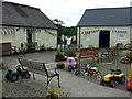
Daily life in SA44 5YJ revolves around practical access to essential retail services. Within practical reach of the residents, you will find three notable retail outlets. Morrisons Daily, Co-op Newcastle, and Spar offer the core conveniences required for everyday shopping. These venues provide groceries, essentials, and basic household items without the need for long-distance travel. The small number of options reflects the rural nature of the postcode, where convenience stores act as the primary lifeline for food and goods. There are no parks, leisure centres, or cultural venues listed in the immediate data, meaning your lifestyle is built around these retail locations and the surrounding homes. You plan your weekly runs around Morrisons Daily and Co-op Newcastle to manage food shopping efficiently. The proximity of Spar allows for quick top-ups between larger grocery hauls. This setup ensures that basic needs are met without the distraction of a busy town centre. Residents of SA44 5YJ enjoy a streamlined shopping experience where high streets are replaced by familiar local stores. The lack of complex commercial zones means the environment remains quiet until these shops open or attract customers. Your day is structured around the reliability of these three names on the signage, ensuring that living here remains practical and grounded.
Amenities
Schools
Educational provisions for families living in SA44 5YJ are represented by a single nearby institution. Ysgol Aberbanc stands as the listed school in the immediate vicinity. This facility is classified as an 'other' type of school. The area does not have a public or special school listed within its primary data profile, limiting the choices for residents who prioritise specific curriculum tracks. You must look to Ysgol Aberbanc to meet primary or secondary education requirements for children growing up in the postcode. This singular option indicates a rural or semi-rural context where residents may need to travel further for comprehensive education options if the school does not fit their needs. Families considering homes in SA44 5YJ need to investigate the catchment area and transport links to Ysgol Aberbanc carefully. The absence of other named schools in the data suggests that this local hub serves the immediate residential cluster. While the school type is general, the proximity ensures that access to formal education is not a major logistical hurdle for parents in this small community. The focus remains on the school's physical presence and its role as the central point for childhood learning in the cluster.
| Rank | School | Type | Entry gender | Ages |
|---|
Explore more schools in this area
Go to Schools tabDemographics
The community within SA44 5YJ is defined by a mature population profile. The median age is 47 years, reflecting a neighbourhood dominated by adults aged between 30 and 64 years. This age range suggests a population that is likely settled, with established careers and families. There is a notable preference for homeownership, with 75% of residents owning their homes outright or with a mortgage. This high percentage indicates a stable community where long-term investment is the norm rather than short-term renting. Accommodation in this cluster consists almost entirely of houses. You will not find flats or high-density blocks here; the housing stock is built for independence and garden space. The demographic makeup is also straightforward, with white residents forming the predominant ethnic group. These facts combine to create a picture of a traditional British residential area where stability is key. The low population density of 59 people per square kilometre supports this view of a less transient, more permanent community. Residents here are likely prioritising security and continuity over urban vibrancy. The social fabric is woven from these house-owning adults, creating an environment where neighbours know one another over decades rather than months. This demographic stability offers a predictable lifestyle for those seeking a home away from the rapid turnover of city centres.
Household Size
Accommodation Type
Tenure
Ethnic Group
Religion
Household Composition
Age
Household Deprivation
NS-SEC
Explore more demographic insights in this area
Go to Demographics tabPlanning
Planning Constraints
- Flood RiskPremium
- Ramsar Wetland SitesPremium
- Area of Outstanding Natural BeautyPremium
- Protected Nature ReservePremium
- Protected WoodlandPremium
- Crime RiskPremium