Area Overview for SA44 5AS
Photos of SA44 5AS

Area Information
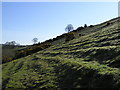
Living in SA44 5AS defines an experience set within a small residential cluster spanning 48.1 hectares. This specific postcode area hosts a total population of 1,764 people, creating a notably sparse environment with just 59 people per square kilometre. The density reflects a community that values space and quiet living rather than the noise of urban sprawl. Residents here inhabit a district that feels like a sanctuary from the busier towns surrounding it, offering a tranquil setting ideal for those seeking a slower pace of life. The area provides a distinct contrast to denser neighbours, where daily commutes and crowded streets are more normal. In SA44 5AS, the layout supports a lifestyle where neighbours are nearby but not intrusive. The geography remains relatively open, avoiding heavy planning constraints such as Ramsar wetland sites or Areas of Outstanding Natural Beauty, which allows for straightforward development. However, the presence of protected nature reserves and woodland indicates a deliberate preservation of green space within the community boundaries. This balance ensures that while growth is possible, the character of the rural pockets remains intact. For anyone considering homes in SA44 5AS, the reality is one of low-density living backed by essential local infrastructure. The area functions as a self-contained haven where residents can enjoy fresh air and open views without being completely isolated from services. It is a place where the scale of life matches the size of the land, providing a practical alternative for families or retirees who prioritise privacy over proximity to city centres.
- Area Type
- Postcode
- Area Size
- 48.1 hectares
- Population
- 1764
- Population Density
- 59 people/km²
The property market in SA44 5AS is characterised by a significant leaning towards owner-occupation, with 75% of homes in the area owned by their residents. This statistic stands in stark contrast to many urban districts where rental markets are more prevalent. Such a high ownership figure implies that the housing stock consists primarily of family homes and mortgages secured over extended periods. The accommodation type is almost exclusively houses, which reinforces the area's appeal to those seeking spacious living rather than compact flats. This market structure benefits buyers looking for stability. When 75% of the population owns their homes, the local economy often reflects confidence and investment in the neighbourhood. It means the area is likely to attract families who stay for the long haul, creating a demand for education, local retail, and park facilities that support settled households. The dominance of houses suggests a layout where gardens and outdoor space are standard features, fitting the median age of 47 for the residents. Prospective buyers viewing homes in SA44 5AS should expect properties designed for longer-term habitation. The scarcity of rental stock points to a community where people buy into the location rather than looking for seasonal or temporary lodgings. While this might limit the variety of accommodation types available for investors, it provides a secure environment for purchase. The housing stock is not a mix of student halls or temporary builds; it is permanent, well-maintained housing that has served its original purpose for decades. This consistency is a key feature of the property landscape in this specific postcode.
House Prices in SA44 5AS
Showing 5 properties
| Address | Type | Beds | Baths | Last Sale Price | Last Sale Date | |
|---|---|---|---|---|---|---|
| Pengraig, Pentrecourt Road, Llandysul, SA44 5AS | Cottage | 2 | 1 | £100,000 | Apr 2019 | |
| Old Toll Gate, Pentrecourt Road, Llandysul, SA44 5AS | Detached | 3 | 1 | £125,000 | Aug 2003 | |
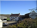
| Tanycoed Farm, Pentrecourt Road, Llandysul, SA44 5AS | house | - | 2 | - | - | |
| Tanycoed Bwthyn, Pentrecourt Road, Llandysul, SA44 5AS | house | - | - | - | - | |
| Caravan, Pengraig, Pentrecourt Road, Llandysul, SA44 5AS | Mobile Home | - | - | - | - |
Energy Efficiency in SA44 5AS
Daily life in SA44 5AS revolves around a practical selection of amenities within practical reach. Buyers can find three key retail outlets, including a Spar, Morrisons Daily, and Co-op Newcastle. These three supermarkets provide essential shopping needs for the 1,764 residents without the need for urban travel. The presence of a Spar sugesats convenience for quick essentials, while Morrisons Daily and Co-op Newcastle offer slightly wider selections for weekly groceries. This cluster of shops ensures that households do not need to drive far for basic necessities, supporting a lifestyle where minor errands can be completed locally. The area maintains a straightforward approach to leisure and services. With no high-end entertainment venues or large leisure centres listed in the immediate amenity data, activities are likely focused around local parks and community spaces. The existence of protected nature reserves and woodland within the boundary suggests that outdoor exploration is a core part of the living experience here. Residents can enjoy walks through green spaces that are legally protected, enhancing the quality of life without commercial distraction. The lack of elaborate retail or dining scenes reflects the area's focus on residence over nightlife. This simplicity appeals to those who prefer a quiet evening at home or a walk in the local woodlands rather than a busy city centre. The amenities available, specifically the three named stores, are sufficient for maintaining a independent household. This self-sufficiency, combined with the open landscape, creates a serene environment where daily life is defined by convenience and nature rather than commercial bustle.
Amenities
Schools
Families looking for schools near SA44 5AS have access to Ysgol Aberbanc, which serves as a local educational facility. This school is listed as an 'other' type, indicating it may be a primary institution, a community college, or a private establishment rather than a mainstream secondary school. Ysgol Aberbanc is the primary educational option highlighted within the immediate reach of the postcode area. The presence of this school supports the local population of 1,764 residents, ensuring that children in SA44 5AS have nearby access to formal education without needing to commute long distances. The mix in the education sector is focused on local provision rather than a range of secondary choices. While Ysgol Aberbanc anchors the educational landscape, the 'other' designation suggests buyers should verify the specific age range and curriculum the school offers. For parents with children in the primary stage, this proximity is a significant advantage. The school's location within the broader SA44 5AS framework means that education is integrated into daily life. The limited school data reflects the small scale of the residential cluster. With a population density of only 59 people per square kilometre, the demand for extensive secondary networks is lower than in larger towns. However, the commitment to local schooling remains high. The area supports a community where children can grow up close to home, attending Ysgol Aberbanc while accessing the wider amenities of the region. This balance between local convenience and regional opportunity makes SA44 5AS suitable for families prioritising proximity to their children's education.
| Rank | School | Type | Entry gender | Ages |
|---|
Explore more schools in this area
Go to Schools tabDemographics
The community profile in SA44 5AS reveals a mature and stable population. The median age sits at 47 years, with adults between 30 and 64 years being the most common demographic group. This indicates a neighbourhood largely comprised of established families and career-focused individuals rather than students or young singles. With 75% of households reporting ownership of their properties, the area possesses a strong sense of long-term commitment. This high ownership rate suggests that most residents have built their lives in SA44 5AS and are unlikely to move frequently. Housing in the postcode is dominated by houses, reflecting a layout suited to family life and gardening rather than high-rise urban dwelling. The predominant ethnic group is White, which aligns with the broader demographic trends of rural Wales. The combination of a higher median age and a majority of owner-occupiers paints a picture of a settled community where tradition and stability are valued. There is a lack of transient populations, fostering a cohesive social fabric where neighbours know each other. This demographic consistency offers a predictable environment for buyers looking to settle down. The age profile also suggests that the local businesses and amenities cater to a population with adult interests and responsibilities, supporting shops that serve daily needs rather than youth-focused entertainment venues.
Household Size
Accommodation Type
Tenure
Ethnic Group
Religion
Household Composition
Age
Household Deprivation
NS-SEC
Explore more demographic insights in this area
Go to Demographics tabPlanning
Planning Constraints
- Flood RiskPremium
- Ramsar Wetland SitesPremium
- Area of Outstanding Natural BeautyPremium
- Protected Nature ReservePremium
- Protected WoodlandPremium
- Crime RiskPremium