Area Overview for SA38 9PN
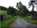
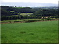
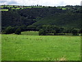
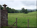
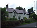
Photos of SA38 9PN

Area Information
Living in SA38 9PN offers a quiet existence within a specific residential cluster covering 2.0 km². This postcode area hosts a population of 1,763 residents, creating a low-density environment where 35 people per square kilometre enjoy spacious surroundings. The location represents a small, contained community rather than a sprawling urban district. You are buying into a neighbourhood defined by its compact size and manageable population levels. The area functions as a tight-knit residential zone where daily life revolves around immediate local needs rather than distant commercial hubs. The character of SA38 9PN is defined by its status as a distinct housing cluster in Wales. It does not offer the anonymity of a large city but provides the intimacy of a defined address. For buyers seeking a specific postcode with clear boundaries, this location delivers exactly that definition. The area size ensures that residents are never far from their neighbours or from the edge of their residential zone. Daily routines here involve short travel distances and a focus on local maintenance and community interaction. This postal sector serves as a snapshot of a wider rural or semi-rural Welsh locality. The density figures indicate a low-pressure environment without the congestion found in larger towns. You will find that life in SA38 9PN prioritises space and stillness over urban excitements. The area acts as a functional home rather than a social destination, focusing on stability and long-term residence.
- Area Type
- Postcode
- Area Size
- 2.0 km²
- Population
- 1763
- Population Density
- 35 people/km²
Homes in SA38 9PN are predominantly houses, fitting the traditional profile of the rural Welsh market. The high home ownership rate of 81% signals that this is an area where families settle rather than rent. Most buyers will find themselves in a sale market where properties change hands rarely, ensuring a stable and predictable community. The accommodation type is strictly houses, ruling out flats or terraced housing as typical options in this specific 2.0 km² area. For investors or first-time buyers, this environment presents a low-turnover market. The density of 35 people per square kilometre implies ample green space and less pressure on shared resources compared to urban centres. You are likely to encounter a mix of established period properties or refurbished homes that have been occupied by the same families for generations. The small area size makes every property highly visible within the local context, reducing anonymity. The market here reflects the needs of the 47-year-old median age resident. Families and older owners drive demand, meaning properties tend to stay in the hands of those who can afford to buy outright or have significant equity. There are no indications of a speculative buy-to-let boom in this specific postcode. The market is characterised by practical living spaces rather than flashy new builds designed for quick flipping.
House Prices in SA38 9PN
Showing 8 properties
Energy Efficiency in SA38 9PN
Daily life in SA38 9PN revolves around locally accessible amenities that meet basic household needs. Within practical reach, you will find two retail outlets: Co-op Newcastle and Morrisons Daily. These shops provide the essentials for weekly shopping, groceries, and household supplies without requiring a long journey. The presence of these named stores confirms that the nearest villages offer standard convenience for residents of this postcode. You will not find luxury shopping malls or large arcades here. The lifestyle in SA38 9PN is defined by these two specific retailers and the quiet streets that surround them. The 35 people per square kilometre density ensures you have personal space while still having access to these local high streets. Walking to these shops is feasible for many residents, though car dependence may exist depending on your specific home location within the 2.0 km² boundary. The area lacks major leisure centres, cinemas, or large parks listed in the immediate data, directing you towards the local shops for community interaction. However, the low maintenance requirement of a smaller population often translates to cleaner, well-kept residential streets. You can use the Co-op and Morrisons as community anchors, visiting them regularly for news and casual chats. The simplicity of the retail offering matches the quiet character of SA38 9PN, avoiding the noise and crowds of bigger towns.
Amenities
Schools
Residents in SA38 9PN rely on three specific institutions for their educational needs, all classified as 'other' types. These are Ysgol Cenarth, Ysgol Trewen, and Ysgol Beulah. The classification of these schools as 'other' distinguishes them from standard comprehensive or infant/secondary divisions often found in larger towns. This mix suggests a localised school system where families engage with a specific set of Welsh-medium or specialist institutions. The proximity of these schools offers convenience for parents living in SA38 9PN. You do not need to navigate heavy traffic to reach the nearest educational facilities. The presence of multiple options within the immediate vicinity allows for some choice based on your specific preferences. Ysgol Cenarth, Ysgol Trewen, and Ysgol Beulah serve the immediate catchment area effectively. The 'other' designation often points to non-grammar status, Vyg (Virtual School), or special needs provision, adding variety to the local education landscape. For families considering homes in SA38 9PN, these schools form the backbone of the local community infrastructure. The names suggest a Welsh language context, which may appeal to bilingual households. The small number of schools indicates a smaller catchment area consistent with the low population of 1,763. You can find that daily commutes to school are short and manageable for residents of this postcode. The educational provision is focused, specialist, and locally grounded.
| Rank | School | Type | Entry gender | Ages |
|---|
Explore more schools in this area
Go to Schools tabDemographics
The community in SA38 9PN is dominated by adults between the ages of 30 and 64 years. This demographic forms the heart of the neighbourhood, reflecting a settled population rather than a transient student or commuter group. The median age of residents is 47 years, confirming that the area appeals to families and established households looking for stability. With 81% of residents owning their homes, the area has a strong culture of long-term residency and investment. The high home ownership rate of 81% indicates that most people in SA38 9PN have put down roots for the long haul. This contrasts sharply with new build estates where rental markets often dominate. Instead, you are joining a neighbourhood where neighbours have likely lived here for years. Accommodation is almost exclusively comprised of houses, meaning high-rise living or flats are not part of the landscape in this postcode. The housing stock reflects a traditional Welsh residential pattern anchored by family homes. Ethnically, the predominant group is White, aligning with the broader demographic profile of many rural areas across Wales. The age profile suggests a quieter environment compared to younger university hubs. Residents are likely to have raised children in the local setting or be nearing retirement. The lack of young people under 30 shifting the social dynamics towards more mature, settled interactions. You are buying into a community defined by stability and established household structures.
Household Size
Accommodation Type
Tenure
Ethnic Group
Religion
Household Composition
Age
Household Deprivation
NS-SEC
Explore more demographic insights in this area
Go to Demographics tabPlanning
Planning Constraints
- Flood RiskPremium
- Ramsar Wetland SitesPremium
- Area of Outstanding Natural BeautyPremium
- Protected Nature ReservePremium
- Protected WoodlandPremium
- Crime RiskPremium